
Geographical Information System Based Multi-Criteria Analysis for Grain Storage Facility Siting in Jalingo Local Government Area, Taraba State, Nigeria
DOI:
https://doi.org/10.33003/fjs-2026-1015-5666Keywords:
Geographic Information System (GIS), Multi-Criteria Decision Analysis (MCDA), Analytical hierarchy process (AHP), Grain Storage, Site Suitability, JalingoAbstract
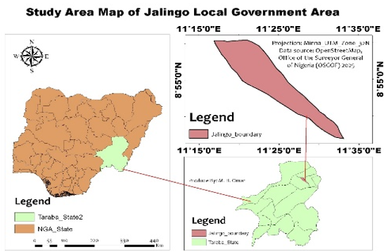
Traditionally, grain storing facilities have been located without any spatial consideration within agrarian Local Government Areas (LGAs) like Jalingo LGA of Taraba State, Nigeria. This has contributed to loss of food security due to post harvest losses. The study developed a model called Multi-Criteria Decision Analysis (MCDA) using Geographic Information System (GIS) for the identification of optimum grain storage facility in Jalingo LGA. Six suitability criteria were tested on Landsat 9 OLI data, a 30 m SRTM Digital Elevation Model (DEM), and other ancillary vector data in ArcGIS Desktop 10.8. The suitability criteria were: land use/land cover, slope, distance to road, distance to river, distance to settlement, proximity to agricultural land. The Analytical Hierarchy Process (AHP) was employed to determine the weights of the criteria by means of a pairwise comparison. Distance to roads (27.4%) and agricultural land (34.9%) were the most important criteria. The consistency ratio of 0.036 suggested the weighting reliability was acceptable. The study area was classified as Suitable or Highly Suitable for grain storage development with the Weighted Sum Analysis, at about 84.7%. The three potential sites identified and ranked by area: Site A (1,468.80 ha), Site C (722.70 ha), and Site B (325.26 ha) were all within a north-western to central accessibility corridor. The results offer a replicable, evidence-based approach to assist in planning for grain storage and reducing postharvest losses in Jalingo LGA and other agro-ecological areas with similar characteristics.
References
Ajibade, T. F., Nwogwu, N. A., Ajibade, F. O., Adelodun, B., Idowu, T. E., Ojo, A. O., Iji, J. O., Olajire, O. O., & Akinmusere, O. K. (2020). Potential dam sites selection using integrated techniques of remote sensing and GIS in Imo State, Southeastern Nigeria. Sustainable Water Resources Management, 6(4), 1–16. https://doi.org/10.1007/s40899-020-00416-5
Barau, A., Musa, M., & Sadiq, I. (2023). Causes and management of postharvest losses in Nigeria: An overview. Journal of Postharvest Technology, 11(3), 86–99.
Chen, Y., Yu, J., & Khan, S. (2010). Spatial sensitivity analysis of multi-criteria weights in GIS-based land suitability evaluation. Environmental Modelling & Software, 25(12), 1582–1591. https://doi.org/10.1016/j.envsoft.2010.06.001
Farr, T. G., Rosen, P. A., Caro, E., Crippen, R., Duren, R., Hensley, S., Kobrick, M., Paller, M., Rodriguez, E., Roth, L., Seal, D., Shaffer, S., Shimada, J., Umland, J., Werner, M., Oskin, M., Burbank, D., & Alsdorf, D. (2007). The Shuttle Radar Topography Mission. Reviews of Geophysics, 45(2), RG2004. https://doi.org/10.1029/2005RG000183
Kumar, D., & Kalita, P. (2017). Reducing postharvest losses during storage of grain crops to strengthen food security in developing countries. Foods, 6(1), 8. https://doi.org/10.3390/foods6010008
Malczewski, J. (2006). GIS-based multicriteria decision analysis: A survey of the literature. International Journal of Geographical Information Science, 20(7), 703–726. https://doi.org/10.1080/13658810600661508
Mathenge, M., Sonneveld, B. G. J. S., & Broerse, J. E. W. (2022). Application of GIS in agriculture in promoting evidence-informed decision making for improving agriculture sustainability: A systematic review. Sustainability, 14(16), 9974. https://doi.org/10.3390/su14169974
Oluwanimifise, M. K., & Anyaeche, C. O. (2025). A GIS and multi-criteria decision analysis for landfill site selection and management in Ibadan, Nigeria. African Journal of Housing and Sustainable Development, 6(2).
Saaty, T. L. (1980). The analytic hierarchy process: Planning, priority setting, resource allocation. McGraw-Hill.
USGS. (2024). Landsat 9. U.S. Geological Survey.
World Bank. (2011). Missing food: The case of postharvest grain losses in Sub-Saharan Africa. World Bank.
Downloads
Published
Issue
Section
Categories
License
Copyright (c) 2026 Muhammad Bashir Omar, Mustapha Usman, Amir Kamal Bello, Idris Moisule Hassan, Salihu Ahmadu, Ezema Andrew Izuchukwu, Nura Isah Adamu, Shazali Ali Jibrin, Sadiq Sani Muhammad Aliyu

This work is licensed under a Creative Commons Attribution 4.0 International License.