
Spatio-temporal Assessment of Desert Encroachment in Maigatari Local Government Area, Jigawa State, Nigeria, Using Ndvi-Base Change Detection (2005-2025)
DOI:
https://doi.org/10.33003/fjs-2026-1011-5517Keywords:
Desertification, Land degradation, NDVI, Remote sensing, GIS, Change detection, Maigatari, Sudano-Sahelian, NigeriaAbstract
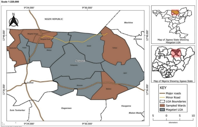
Desert encroachment poses a critical threat to dryland ecosystems and rural livelihoods in the Sudano-Sahelian region of northern Nigeria. This study assesses the spatiotemporal dynamics of vegetation change and desertification intensity in Maigatari Local Government Area (LGA), Jigawa State, between 2005 and 2025. Using multi-temporal Landsat satellite imagery (Landsat 5 TM, Landsat 8 OLI, and Landsat 9 OLI), the Normalized Difference Vegetation Index (NDVI) was computed and classified into three land cover categories: bare land, sparse vegetation, and moderate vegetation. Change detection analysis was performed to quantify transitions across two decadal intervals (2005–2015 and 2015–2025). Results reveal a substantial expansion of bare land from 0.0032 km² (0.0013%) in 2005 to 67.06 km² (26.21%) in 2015, representing an 80% increase, indicating accelerated degradation during the first decade. Sparse vegetation declined sharply from 97.66% to 45.06% over the same period. Between 2015 and 2025, bare land continued to expand to 74.70 km² (29.21%), while moderate vegetation increased locally from 28.72% to 38.59%, suggesting partial recovery in isolated areas. The overall trajectory, however, confirms progressive desert encroachment with net vegetation loss. The findings underscore the urgent need for integrated land management strategies, including sustainable grazing, agroforestry, and farmer-managed natural regeneration. This study demonstrates the efficacy of NDVI-based change detection within a GIS framework as a tool for evidence-based environmental planning and desertification monitoring in semi-arid regions.
References
Adefolalu, D. O. (2007). Climate change and sustainable development in Nigeria. Ibadan: Stirling-Horden Publishers.
Brandt, M., Rasmussen, K., Peñuelas, J., Tian, F., Schurgers, G., Verger, A., & Fensholt, R. (2018). Human population growth offsets climate-driven increase in woody vegetation in sub-Saharan Africa. Nature Ecology & Evolution, 2(4), 650-655.
Dardel, C., Kergoat, L., Hiernaux, P., Mougin, E., Grippa, M., & Tucker, C. J. (2014). Re-greening Sahel: 30 years of remote sensing data and field observations (Mali, Niger). Remote Sensing of Environment, 140, 350-364.
Fensholt, R., Langanke, T., Rasmussen, K., Reenberg, A., Prince, S. D., Tucker, C., & Wessels, K. (2012). Greenness in semi-arid areas across the Sahel 1982–2007: an analysis based on the GIMMS NDVI3g dataset. Remote Sensing of Environment, 121, 144-158.
Giannini, A., Ali, A., & Kelley, C. P. (2025). An imminent return to drought in the western Sahel? Science Advances, 11(34), eadu5415.
Geist, H. J., & Lambin, E. F. (2004). Dynamic causal patterns of desertification. BioScience, 54(9), 817-829.
Herrmann, S. M., Anyamba, A., & Tucker, C. J. (2005). Recent trends in vegetation dynamics in the African Sahel and their relationship to climate. Global Environmental Change, 15(4), 394-404.
Hickler, T., Eklundh, L., Seaquist, J. W., Smith, B., Ardö, J., Olsson, L., & Sjöström, M. (2005). Precipitation controls Sahel greening trend. Geophysical Research Letters, 32(21).
Ibrahim, A., Sani, A. A., & Mohammed, A. (2020). Assessment of drought vulnerability in Jigawa State, Nigeria. Journal of Arid Environments, 175, 104-112.
IPCC. (2022). Climate Change 2022: Impacts, Adaptation and Vulnerability. Contribution of Working Group II to the Sixth Assessment Report of the Intergovernmental Panel on Climate Change. Cambridge University Press.
Jensen, J. R. (2016). Introductory Digital Image Processing: A Remote Sensing Perspective (4th ed.). Pearson Education, Inc.
Kennedy, R. E., Yang, Z., & Cohen, W. B. (2010). Detecting trends in forest disturbance and recovery using yearly Landsat time series: 1. LandTrendr-Temporal segmentation algorithms. Remote Sensing of Environment, 114(12), 2897-2910.
Mortimore, M., & Harris, F. (1999). Livelihood diversification and land degradation in northern Nigeria. Drylands Research Working Paper, 17.
National Population Commission. (2022). Population Projections for Nigeria. Abuja, Nigeria.
Ogle, K., & Reynolds, J. F. (2004). Plant responses to precipitation in desert ecosystems: integrating functional types, pulses, thresholds, and delays. Oecologia, 141, 282-294.
Olsson, L., Eklundh, L., & Ardö, J. (2005). A recent greening of the Sahel-trends, patterns and potential causes. Journal of Arid Environments, 63(3), 556-566.
Reynolds, J. F., Smith, D. M. S., Lambin, E. F., Turner, B. L., Mortimore, M., Batterbury, S. P., & Huber-Sannwald, E. (2007). Global desertification: building a science for dryland development. Science, 316(5826), 847-851.
Reynolds, J. F., & Stafford Smith, D. M. (2011). From Theory to Rural Farms: Testing the Efficacy of the Dryland Development Paradigm of Desertification. AGU Fall Meeting Abstracts, GC51C-0999.
Salami, A. T., Balogun, E. E., & Ogunleye, O. O. (2021). Land degradation assessment in northern Nigeria using geospatial techniques. Nigerian Journal of Environmental Science, 15(2), 45-58.
Saleh, M. M., Bello, A. G., & Yusuf, M. B. (2020). Soil properties and land use impacts in Sudano-Sahelian zone of Nigeria. Journal of Soil Science and Environmental Management, 11(3), 89-97.
Seaquist, J. W., Hickler, T., Eklundh, L., Ardö, J., & Heumann, B. W. (2009). Disentangling the effects of climate and people on Sahel vegetation dynamics. Biogeosciences, 6(3), 469-477.
Singh, A. (1989). Review article: digital change detection techniques using remotely-sensed data. International Journal of Remote Sensing, 10(6), 989-1003.
TNC, & World Economic Forum. (2024). The Great Green Wall: Unlocking the Potential of Carbon Markets. White Paper.
UNCCD. (2022). The Global Land Outlook (2nd ed.). United Nations Convention to Combat Desertification.
UNCCD. (2024). Great Green Wall Observatory. Accessed via African Development Bank Report.
UNDP. (2011). Calculating and Reporting Indicators: A Practical Guide. United Nations Development Programme.
Wang, J., & Sui, Y. (2025). Comparative Global Assessment and Optimization of LandTrendr, CCDC, and BFAST Algorithms for Enhanced Urban Land Cover Change Detection Using Landsat Time Series. Remote Sensing, 17(14), 2402.
Xue, J., & Su, B. (2017). Significant remote sensing vegetation indices: A review of developments and applications. Journal of Sensors, 2017, 1-17.
Yahaya, I. I., Wang, Y., Zhang, Z., Inuwa, A. Y., Zhao, Y., You, Y., & Shoukat, W. (2024). Assessing desertification vulnerability and mitigation strategies in northern Nigeria: A comprehensive approach. Heliyon, 10(11), e31167.
Zhu, Z., & Woodcock, C. E. (2014). Continuous change detection and classification of land cover using all available Landsat data. Remote Sensing of Environment, 144, 152-171.
Downloads
Published
Issue
Section
Categories
License
Copyright (c) 2026 Sadiq Ahmed, Abdulmajid Abubakar

This work is licensed under a Creative Commons Attribution 4.0 International License.