
AN INTEGRATED GNSS, DATUM TRANSFORMATION, AND IOT FRAMEWORK FOR DIGITAL GEODETIC CONTROL POINT INFRASTRUCTURE IN URBAN ENVIRONMENTS
DOI:
https://doi.org/10.33003/fjs-2026-1007-4796Keywords:
GNSS, IoT, Geodetic control points, Datum transformation, Spatial data, infrastructure, Smart cityAbstract
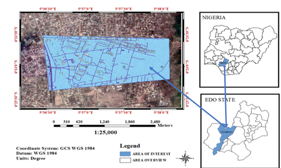
Accurate and accessible geodetic control point information is essential for modern surveying, mapping, and geospatial data infrastructure development. However, conventional analogue-based documentation systems are often fragmented, poorly maintained, and inefficient, particularly in rapidly urbanizing environments. This study presents the development and implementation of a semi-automatic Internet of Things (IoT)-enabled virtual repository for the storage, management, and retrieval of geodetic control point data, integrating high-precision Global Navigation Satellite System (GNSS) observations with systematic datum transformation. Static GNSS observations were conducted at selected control points in Benin City, Nigeria, and processed using continuously operating reference station (CORS) corrections to obtain precise three-dimensional coordinates in both the local Minna datum and the global WGS84/ITRF reference frame. Datum transformation was applied to evaluate positional consistency between the two coordinate systems, and the derived datasets were integrated into a centralized IoT-based web platform for real-time data access, visualization, and archival management. The results achieved centimetre-level horizontal accuracy and decimetre-level vertical precision, confirming the robustness of the adopted GNSS methodology. Comparative analysis revealed systematic horizontal shifts of less than 0.5 m and vertical discrepancies approaching 1.0 m, emphasizing the importance of accurate transformation models. The developed platform demonstrated efficient data storage, rapid retrieval, and reliable accessibility, providing a scalable solution for modernizing geodetic infrastructure, supporting smart city initiatives, and strengthening spatial data governance in developing urban environments.
References
Aderinto S, Osifodunrin P. (2012) The third wave of historical scholarship on Nigeria: Essays in honor of Ayodeji Olukoju. Cambridge Scholars Publishing, Newcastle upon Tyne.
Agajelu SI, Moka EC. (1989) An estimate of the transformation for the Minna–Nigeria geodetic network. The Australian Surveyor. 34 (5): 345–352..
Akhigbe RA, Oladosu SO, Ehigiator-Irughe R. (2023) Geodetic control extension at erosion-prone areas using integrated CORS–GNSS in Benin City, Edo State, Nigeria. Dutse Journal of Pure and Applied Sciences (DUJOPAS). 9 (3b): 112–125. https://doi.org/10.4314/dujopas.v9i3b.27
Bielecka E, Pokonieczny K, Kamiński P. (2014) Study on spatial distribution of horizontal geodetic control points in rural areas. Acta Geodaetica et Geophysica. 49: 357–368.
https://doi.org/10.1007/s40328-014-0056-6
Borah R. (2024) Cloud computing architecture: What is front end and back end? Clarion Technologies available at.
https://www.clariontech.com/blog/cloud-computing-architecture-what-is-front-end-and-back-end
Chen M, Miao Y, Humar I. (2020) OPNET IoT simulation. Springer Nature Singapore, Singapore.https://doi.org/10.1007/978-981-32-9172-0
Dodo JD, Idowu TO. (2011) A proposal for the extension and institutional framework of European Geostationary Navigation Overlay Service (EGNOS) in the implementation of Global
Navigation Satellite System (GNSS) in Africa. FUTY Journal of the Environment. 6 (1): 45–56.
Ehigiator-Irughe R, Audu HAP. (2016) Determination of horizontal and vertical positional accuracy from GNSS geodetic observation. Tropical Environment. 13 (1): 34–45.
Ehigiator-Irughe R, Oladosu SO. (2022) Assessment of 3D positional accuracy of geodetic observations from single CORS. Geological Behaviour. 6 (2): 96–101. https://doi.org/10.26480/gbr.02.2022.96.101
Ehigiator-Irughe R, Oladosu SO. (2023) Densification of first-order geodetic controls within the University of Benin, Nigeria. ATBU Journal of Environmental Technology. 16 (1): 55–74.
Ehigiator MO, Oladosu SO, Ehigiator-Irughe R. (2017) Densification of GNSS control points for cadastral and mapping purposes. Nigerian Journal of Environmental Sciences and Technology
(NIJEST). 1 (2): 287–298.
Ehigiator-Irughe R, Ehigiator MO, Uzoekwe SA. (2011) Establishment of geodetic control in Jebba Dam using CSRS–PPP processing software. Journal of Emerging Trends in Engineering and Applied Sciences (JETEAS). 2 (5): 763–769.
Fajemirokun FA, Nwilo PC. (1990) Ground controls towards effective
national mapping policy. Proceedings of the Symposium on the
Contribution of Photogrammetry and Remote Sensing to National
Development, University of Lagos, Lagos, Nigeria, 14–15 June,
pp. 45–52.
Featherstone W, Reit BG. (1998) Modified map projection: Transforming map-grid coordinates between the Australian geodetic datum and geocentric datum of Australia. Surveying
Australia. 32–37.
Finkelstein D, McCleery A. (2006) An introduction to book history. Routledge, London.
https://doi.org/10.4324/9780203969708
Hershaft AP. (2011) National education technology plan: Education in a competitive and globalizing world. Nova Science Publishers, New York.
Janečka K. (2019) The integrated management of information about the geodetic point fields: A case of the Czech Republic. Geosciences. 9 (7): 307.https://doi.org/10.3390/geosciences9070307
Lu Z, Qu Y, Qiao S. (2014) Geodetic datum and geodetic control networks. In: Geodesy. Springer, Berlin, pp. 71–130.https://doi.org/10.1007/978-3-662-46900-4_4
Nwilo PC, Okolie CJ, Onwuzuligbo CU. (2016) Technological advancements in geodetic infrastructure: The Nigerian adaptation. Proceedings of the Nigeria Association of Geodesy 2016 General Assembly and Conference, Enugu, Nigeria, pp. 1–15.
Ruffhead AC, Whiting BM. (2020) Introduction to geodetic datum transformations and their reversibility. Surveying Working Paper No. 01/2020.
Sánchez L, Wziontek H, Wang YM, et al. (2023) Towards an integrated global geodetic reference frame: Preface to the special issue on reference systems in physical geodesy. Journal of Geodesy. 97: 59.https://doi.org/10.1007/s00190-023-01758-6
Yan M, Shi H. (2013) Smart living using Bluetooth-based Android smartphone. International Journal of Wireless & Mobile Networks (IJWMN). 5 (1): 65–74. https://doi.org/10.5121/ijwmn.2013.5106
Downloads
Published
Issue
Section
Categories
License
Copyright (c) 2026 Stephen Olushola Oladosu, Geoffrey Ogbonna Nwodo, Raphael Ehigiator-Irughe

This work is licensed under a Creative Commons Attribution 4.0 International License.

