
Spatial and Temporal Analysis of Borrow-Pit Distribution in the Kano River and Hadejia Valley Irrigation Schemes, Nigeria
DOI:
https://doi.org/10.33003/Keywords:
Borrow Pits, Spatial Distribution, Average Nearest Neighbour, Irrigation Schemes, Land Degradation, GIS, NigeriaAbstract
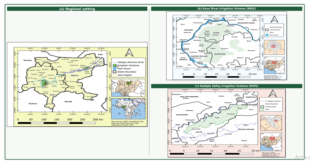
Borrow pits supply earth materials for irrigation, construction and rehabilitation, but their spatial expansion can create persistent land-management concerns when excavation is poorly planned or when restoration is inadequate. This study analysed the spatial and temporal distribution of mapped borrow pits in the Kano River Irrigation Scheme (KRIS) and Hadejia Valley Irrigation Scheme (HVIS) in northern Nigeria for 1999, 2009, and 2019. Historical Google Earth imagery was visually interpreted and digitised, while 2019 locations were field-verified with a Garmin eTrex 32x receiver. Borrow-pit polygons and centroids were processed in ArcMap 10.3.1, and Average Nearest Neighbour analysis was used to assess spatial pattern. The mapped inventory increased from 19 to 21 and from 34 to 55 pits in KRIS, and from 21 to 26 and from 55 to 75 pits in HVIS across the three reference years. From 1999 to 2019, mapped pit counts increased by 78.9% in KRIS and 161.9% in HVIS, while the combined inventory rose from 40 to 89 pits. All six scheme-year distributions were clustered, with nearest-neighbour ratios of 0.50–0.51 in KRIS and 0.60–0.71 in HVIS. By 2019, mapped excavation footprints occupied approximately 180.2 ha in KRIS and 219.6 ha in HVIS. These results demonstrate the expansion and spatial concentration of mapped excavations, but do not, by themselves, establish the causes, legal status, or magnitude of environmental damage. The study provides a geospatial baseline for inventory management, field inspection, rehabilitation planning and future cumulative-impact assessment.References
Adedeji, O. H., Adebayo, H. O., & Sotayo, E. I. (2014). Assessing environmental impacts of inland sand mining in parts of Ogun State, Nigeria. Ethiopian Journal of Environmental Studies and Management, 7(5), 478–487. https://doi.org/10.4314/ejesm.v7i5.2
Bendixen, M., Iversen, L. L., Best, J., Franks, D. M., Hackney, C. R., Latrubesse, E. M., & Tusting, L. S. (2021). Sand, gravel, and UN Sustainable Development Goals: Conflicts, synergies, and pathways forward. One Earth, 4(8), 1095–1111. https://doi.org/10.1016/j.oneear.2021.07.008
Esri. (2023). How average nearest neighbor works. ArcGIS Pro documentation. https://pro.arcgis.com/en/pro-app/latest/tool-reference/spatial-statistics/h-how-average-nearest-neighbor-distance-spatial-statistics-works.htm
Farr, T. G., Rosen, P. A., Caro, E., Crippen, R., Duren, R., Hensley, S., Kobrick, M., Paller, M., Rodriguez, E., Roth, L., Seal, D., Shaffer, S., Shimada, J., Umland, J., Werner, M., Oskin, M., Burbank, D., & Alsdorf, D. (2007). The Shuttle Radar Topography Mission. Reviews of Geophysics, 45(2), Article RG2004. https://doi.org/10.1029/2005RG000183
Filho, W. L., Hunt, J., Lingos, A., Platje, J., Vieira, L. W., Will, M., & Gavriletea, M. D. (2021). The unsustainable use of sand: Reporting on a global problem. Sustainability, 13(6), Article 3356. https://doi.org/10.3390/su13063356
Getis, A., & Ord, J. K. (1992). The analysis of spatial association by use of distance statistics. Geographical Analysis, 24(3), 189–206. https://doi.org/10.1111/j.1538-4632.1992.tb00261.x
Gidado, U. M., Jokolo, M. A., & Saleh-Bala, M. (2023). Community monster: Reclaiming the borrow pits in Batagarawa community of North-Western Nigeria. COOU African Journal of Environmental Research, 4(2), 151–164. https://ajer.org.ng/index.php/journal/article/view/108
Hackney, C. R., Darby, S. E., Parsons, D. R., Leyland, J., Best, J. L., Aalto, R., Nicholas, A. P., & Houseago, R. C. (2020). River bank instability from unsustainable sand mining in the lower Mekong River. Nature Sustainability, 3(3), 217–225. https://doi.org/10.1038/s41893-019-0455-3
Hassan, I. U., Garba, Y. I., & Hussain, A. (2025). Effects of agrochemicals and their impact on soil quality in part of Sudan Savannah zone of Northwestern Nigeria. FUDMA Journal of Sciences, 9(3), 7–14. https://doi.org/10.33003/fjs-2025-0903-2693
Mohammed, D., Maina, M., Audu, I., Tudun Wada, I., & Nasir, N. (2021). Remote sensing techniques in mapping spatial variability of salinity in Kano River Irrigation Project (KRIP), Nigeria. Nigerian Journal of Technology, 40(4), 732–739. https://doi.org/10.4314/njt.v40i4.20
Nwachukwu, M. A., Nwachukwu, M. I., Ahiarakwem, C. A., & Nwankwo, G. I. (2017). Abandoned borrow pits: Risk factors and reclamation procedure. MOJ Civil Engineering, 2(3), 88–95. https://doi.org/10.15406/mojce.2017.02.00033
Peduzzi, P. (2014). Sand, rarer than one thinks. United Nations Environment Programme, Global Environmental Alert Service. https://wedocs.unep.org/handle/20.500.11822/8665
Rabus, B., Eineder, M., Roth, A., & Bamler, R. (2003). The Shuttle Radar Topography Mission: A new class of digital elevation models acquired by spaceborne radar. ISPRS Journal of Photogrammetry and Remote Sensing, 57(4), 241–262. https://doi.org/10.1016/S0924-2716(02)00124-7
Rentier, E. S., & Cammeraat, L. H. (2022). The environmental impacts of river sand mining. Science of the Total Environment, 838, Article 155877. https://doi.org/10.1016/j.scitotenv.2022.155877
Torres, A., Brandt, J., Lear, K., & Liu, J. (2017). A looming tragedy of the sand commons. Science, 357(6355), 970–971. https://doi.org/10.1126/science.aao0503
Torres, A., Simoni, M. U., Keiding, J. K., Müller, D. B., zu Ermgassen, S. O. S. E., Liu, J., Jaeger, J. A. G., Winter, M., & Lambin, E. F. (2021). Sustainability of the global sand system in the Anthropocene. One Earth, 4(5), 639–650. https://doi.org/10.1016/j.oneear.2021.04.011
Transforming Irrigation Management in Nigeria Project. (2017). Environmental and social impact assessment for rehabilitation of the Kano River Irrigation Scheme. Federal Ministry of Water Resources.
Transforming Irrigation Management in Nigeria Project. (2020). Mid-term review report of the Transforming Irrigation Management in Nigeria Project. Federal Ministry of Water Resources and World Bank.
United Nations Environment Programme. (2019). Sand and sustainability: Finding new solutions for environmental governance of global sand resources. https://wedocs.unep.org/handle/20.500.11822/28163
Werner, T. T., Bebbington, A., & Gregory, G. (2019). Assessing impacts of mining: Recent contributions from GIS and remote sensing. The Extractive Industries and Society, 6(3), 993–1012. https://doi.org/10.1016/j.exis.2019.06.011
Downloads
Published
Issue
Section
Categories
License
Copyright (c) 2026 Haruna Manu Isah, Ahmed Fate Ali, Abdullahi Babagana, Isah Usman Hassan

This work is licensed under a Creative Commons Attribution 4.0 International License.