
Assessing the Performance of Established GNSS Post-Processing Software on Static GNSS Datasets, Kubwa, Abuja
DOI:
https://doi.org/10.33003/fjs-2026-1013-5505Keywords:
Ambiguity Resolution, Geodetic Surveying, Post-Processing Software, Positioning Accuracy, Static GNSSAbstract
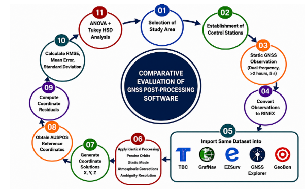
The selection of appropriate Global Navigation Satellite System (GNSS) post-processing software is critical for achieving reliable centimeter-level positioning in engineering and geodetic applications. This study evaluated the performance of five GNSS post-processing software packages—Trimble Business Center (TBC), GrafNav, EZSurv, GNSS Explorer, and GeoBon—using identical static multi-constellation GNSS datasets acquired from twelve geodetic control stations in Kubwa, Abuja, Nigeria. Static observations were collected with dual-frequency GNSS receivers at a 5 s sampling interval over sessions exceeding two hours and processed under identical configurations using precise orbit products, standard atmospheric corrections, and carrier-phase ambiguity resolution. Coordinate solutions were evaluated against AUSPOS-derived reference coordinates using coordinate residuals, root mean square error (RMSE), ambiguity-fixing success rate, processing time, and one-way Analysis of Variance (ANOVA) with Tukey's Honestly Significant Difference (HSD) test. All software packages achieved centimeter-level positioning accuracy. GrafNav delivered the best overall performance, recording the lowest horizontal and vertical RMSE values (0.009 m and 0.014 m, respectively) and the highest ambiguity-fixing success rate (99.6%). At the same time, TBC achieved comparable accuracy with faster processing. EZSurv also produced reliable solutions, whereas GNSS Explorer and GeoBon exhibited larger residuals but remained within acceptable surveying tolerances. ANOVA revealed significant differences among the software packages for both horizontal (p = 0.0019) and vertical (p = 0.0007) positioning. The results demonstrate that processing algorithms and ambiguity-resolution strategies significantly influence static GNSS positioning performance and provide practical guidance for software selection in high-precision surveying within tropical environments.
References
Ahmed, E. (2011). Analysis of web-based GNSS post-processing services for static and kinematic positioning using short data spans. Survey Review, 43(323): 535-549. DOI:10.1179/003962611X13117748892074
Aleem, K. F., & Abubakar, A. F. (2022). The review and development of the Nigerian geodetic control network. Journal of Geospatial Surveying, 2(2).
Atoki, L. O., Buraimoh, K. S., Sangotoye, O. A. and Edoki, E. I. (2025). Evaluating the Consistency of GNSS Repeat Measurements: Effects of Orbital Errors on Same-Time, Same-Date Observations in Different Years in Abuja, Nigeria. Journal of Spatial Information Sciences, 2(1), 189–205. https://doi.org/10.5281/zenodo.14947243
Atoki, L. O., Ono, M. N. and Edoki, E. I. (2024a). Evaluation of Tropospheric Influence on Positioning Accuracy Using IGS03 Data Stream Compared to Static PPP in Abuja, Nigeria. International Journal of Advances in Engineering and Management, 6(8), 499–508.
Atoki, L. O., Ono, M. N. and Ibraheem, S. T. (2024b). Assessing Tropospheric Impacts on Positioning Accuracy Using IGS02 Real-Time Service Data versus Static PPP. IJLTEMAS, XIII(VIII).
Atoki, L. O., Ono, M. N. and Ibraheem, S. T. (2024c). Assessment of Positioning with IGS02 and IGS03 Real-Time Service Data Compared to Static PPP. IJRIAS, IX(IX).
Ayodele, E. G., Okolie, C. J., Ezeigbo, C. U., & Fajemirokun, F. A. (2019). Evaluating the stability and adequacy of NIGNET for the definition of Nigerian Geodetic Reference Frame. Nigerian Journal of Technological Development, 17(1). https://doi.org/10.4314/njtd.v17i1.1
Hofmann-Wellenhof, B., Lichtenegger, H., & Wasle, E. (2008). GNSS – Global Navigation Satellite Systems: GPS, GLONASS, Galileo, and More. Springer.
Isioye, O. A., Moses, M., and Abdulmumin, L. (2018). Comparative Study of Some Online GNSS Post-Processing Services at Selected Permanent GNSS Sites in Nigeria. Accuracy of GNSS Methods. DOI:10.5772/intechopen.79924
Jamieson, M., and Gillins, D. T. (2018). Comparative Analysis of Online Static GNSS Postprocessing Services. Journal of Surveying Engineering, 144(4). DOI:10.1061/(ASCE)SU.1943-5428.0000256
Lau, L., & Tai, K. W. (2023). A data quality assessment approach for high-precision GNSS continuously operating reference stations (CORS) with case studies in Hong Kong and Canada/USA. Remote Sensing, 15(7), 1925. https://doi.org/10.3390/rs15071925
Mustafa, T., Abduhaq, H., and Husham, F. (2017). Accuracy Assessment of Different GNSS Processing Software. Imperial Journal of Interdisciplinary Research (IJIR), 3(10), 469-478
NOAA (2022). Guidelines for GNSS Surveying and Processing. National Oceanic and Atmospheric Administration.
Nwilo, P. C., Ayodele, E. G., Okolie, C. J., Orji, M. J., Marve, M. F., Oyelade, E. A., & Daramola, O. E. (2020). An assessment of seasonal variations in the CREF CORS at the University of Lagos. Geomatics, Land Management and Landscape, 1, 63-70. https://doi.org/10.15576/GLL/2020.1.63
Raza, S., Al-Kaisy, A., Teixeira, R., & Meyer, B. (2022). The role of GNSS-RTN in transportation applications. Encyclopedia, 2(3), 83.
Tata, H. (2020). Assessing the accuracy of online GNSS processing services and commercial software. South African Journal of Geomatics, 9(2), 145–158.
Tata, H., Nzelibe, I. U., and Ibrahim, O. R. (2022). Assessing the accuracy of online GNSS processing services and commercial software on short baselines. South African Journal of Geomatics 9(2):321-332. DOI:10.4314/sajg.v9i2.21
Tata, H. (2019). Accuracy assessments of differential global positioning system (DGPS) and high-resolution satellite image (HRSI) for cadastral surveying. FUTY Journal of the Environment, 13(2), 49-57.
Teunissen, P. J. G. (1995). The least-squares ambiguity decorrelation adjustment: A method for fast GPS integer ambiguity estimation. Journal of Geodesy, 70(1–2), 65–82. https://doi.org/10.1007/BF00863419.
Teunissen, P. J. G., & Montenbruck, O. (Eds.). (2017). Springer handbook of global navigation satellite systems. Springer.
Downloads
Published
Issue
Section
Categories
License
Copyright (c) 2026 Lucas Olu Atoki; Ojodugbowa Shedrack Omachoko, Samuel Korede Buraimoh, Oluwagbotemi Odesola; Ololade Ayotunde Sangotoye

This work is licensed under a Creative Commons Attribution 4.0 International License.