
GNSS/Levelling-Based Assessment of Vertical Deformation along the Jonathan Bypass Airport Road, Calabar (Nigeria), Using the 3-Sigma Statistical Criterion
DOI:
https://doi.org/10.33003/fjs-2026-1010-5198Keywords:
GPS/leveling, 3-Sigma rule, Deflection of the Vertical, Calabar's Airport Road, DeformationAbstract
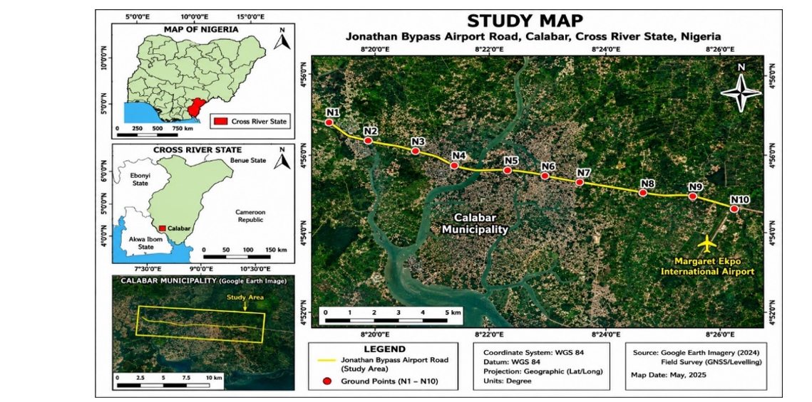
Recently, urban areas have seen a rise in road subsidence accidents, endangering citizens. Detecting structural movement early means catching small movements, allowing for timely intervention. Various high-precision methods have been tested and implemented to mitigate these risks. This study uses the 3-sigma rule to isolate outliers and detect deformation. It combines GNSS and leveling techniques to determine vertical deflection, identifying areas prone to cave-ins and correlating them with road surface deformation. The study derived optimal Deflection of Vertical (DoV) along Calabar's Airport Road with millimeter accuracy, using geodetic coordinates (ϕ, λ, h) and orthometric height (H). The 3-sigma test showed an SD of less than 4mm and DoV of less than 4mm, indicating inliers. Correlation analysis of DoV revealed moderate positive correlation (0.460) between 2022-2023, strong positive correlation (0.802) between 2022-2024, and moderate positive correlation (0.551) between 2023-2024. The study has demonstrated the effectiveness of GNSS and leveling techniques in monitoring road deformation, thereby highlighting areas of significant change in Calabar’s Airport Road profiles. Alternative methods, such as GNSS/leveling techniques, are recommended for obtaining reliable, high-quality DoV data. These methods offer solutions to the high costs of gravimeters and satellite data resolution limitations in Nigeria, exacerbated by the economic downturn.
References
Abulizi, N., Kawamura, A., Tomiyama, K. and Fujita, S. (2016). Measuring and evaluating of road roughness conditions with a compact road profiler and ArcGIS. Journal of Traffic and Transportation Engineering; 3(5):398e411
Albayrak, M.; Marti, U.; Willi, D.; Guillaume, S.; Hardy, R.A. (2024). Precise Geoid Determination in the Eastern Swiss Alps Using Geodetic Astronomy and GNSS/Leveling Methods. Sensors, 24, 7072. https://doi.org/10.3390/s24217072
Battaglia, M., Hill, D.P. (2009). Analytical modeling of gravity changes and crustal deformation at volcanoes: The Long Valley caldera, California, case study. Tectonophysics 471 (1–2), 45–57.
Burger. M. (2013), Calculating road input data for vehicle simulation. Multibody System of Dynamics. 31: 93–110.
Ceylan A. (2009). Determination of the Deflection of Vertical Components via GPS and Leveling Measurement: A Case Study of a GPS Test Network in Konya, Turkey. Scientific Research and Essay. (4):12, Academic Journals, http://www.academicjournals.org/SRE
Ding, L., Qin, F.C., Fang, H.D., Liu, H., Zhang, B., Shu, C.Q., Deng, Q.C., Liu, G.C. and Yang, Q.Q. (2017). Morphology and controlling factors of the longitudinal profile of gullies in the Yuanmou dry-hot valley. Journal of Mountain Science. 14: 674–693, https://doi.org/10.1007/s11629-016-4189-7.
Dong, C. Nambisan, S. S., Richards, S. H. and Ma, Z. (2015). Assessment of the effects of highway geometric design features on the frequency of truck involved crashes using bivariate regression, Transportation Research Part a Policy and Practice 75, DOI:10.1016/j.tra.2015.03.007.
Dumka, R. K. SuriBabu, D., Kotlia, B.S., Kothyari, G. C. and Prajapati, S. (2022). Crustal deformation measurements by global positioning system (GPS) along NSL, western India. Geodesy and Geodynamics, 13: 254-260.
Edoki, E. I.; Ono, M. N. and Atoki, L. O. (2024) a. Characterization and Mapping of Calabar Flank Crustal Deformation Using Sentinel -1 Data. International Journal of Engineering Inventions, Volume 13, Issue 9, PP: 88-92
Edoki, E. I.; Ono, M. N.; Igwebuike, A. E. (2024) b. Integrated Analysis of Gravity and Geoidal Anomalies for Understanding Crustal Deformation and Tectonic Processes in the Calabar Flank, Nigeria. International Journal of Multidisciplinary Research and Growth Evaluation. Volume: 05, Issue: 05, 371-377
Epuh, E.E., Moshood, A.I., Okolie, C.J., Daramola, O.E., Akinnusi, S.A., Arungwa, I., Orji, M.J., Olanrewarju, H.O. and Fatoyinbo, A .A . (2022). Integration of satellite gravimetry, multispectral imagery and digital elevation model for investigating crustal deformation in the Niger Delta Basin. Geosystems and Geoenvironment 1, 100067.
Featherstone, W. and Morgan, L. (2007). Validation of the AUSGeoid98 model in Western Australia using historic astrogeodetically observed deviations of the vertical, Journal of the Royal Society of Western Australia. 90(3):143-150.
Gorges, C., Öztürk, K. and Liebich, R. (2017). Road classification for two-wheeled vehicles, Engineering Design and Product Reliability, Berlin Institute of Technology, Berlin, Germany, http://www.tandfonline.com/10.1080/00423114.2017.1413197.
Harris, N. K., González, A., OBrien E. J. and McGetrick, P. J. (2010). Characterisation of pavement profile heights using accelerometer readings and a combinatorial optimization technique. Journal of Sound and Vibration, 329(5) 497–508, DOI: 10.1016/j.jsv.2009.09.035.
Hekimoglu, S., and Koch, K. R. (2000). “How can reliability of the test for outliers be measured?” Allgemeine Vermessungsnachrichten, 7, 247–253
ISO (2016). Mechanical vibration - Road surface profiles - Reporting of measured data.
Standard No. 8608:2016. Geneva, Switzerland.
Johannesson, P. and Speckert, M. (2013). Guide to load analysis for durability in vehicle engineering. Chichester, Wiley, 434.
Johnson, C., Affolter, M.D., Inkenbrandt, P., Mosher, C. (2019). An Introduction to Geology. Faculty (Geology) Salt Lake Community College.
Kadirov F., Yetirmishli G., Safarov R., Mammadov S., Kazimov I., Floyd M., Reilinger R., King R. (2024). Results from 25 Years (1998‐2022) Of Crustal Deformation Monitoring in Azerbaijan and Adjacent Territory Using GPS. ANAS Transactions, Earth Sciences 1, 28‐43; DOI: 10.33677/ggianas20240100107
Karlsson, M. (2007). Load modelling for fatigue assessment of vehicles – a statistical approach. PhD thesis. Göteborg, Sweden: Chalmers, Göteborg University.
Kim, Y.R. (2014). Subsidence occurrence and countermeasure by sewer. Water J. 11, 73–78.
Lee, S.Y.; Kang, J.M.; Kim, J.Y. (2022). Development of Machine Learning Model to predict the ground subsidence risk grade according to the Characteristics of underground facility. J. Korean Geo-Environ. Soc., 23, 5–10.
Lee, S.; Kang, J.; Kim, J. (2023). A Study on Factors Influencing Ground Subsidence and a Risk Analysis Method Using the Attributes of Sewer Pipes. Appl. Sci., 13, 9714. https://doi.org/10.3390/app13179714
Lehmann, R. (2013). On the Formulation of the Alternative Hypothesis for Geodetic Outlier Detection. Journal of Geodesy, .87(4), pp 373-386.
Liu, L. and Zhang, C. (2020). Analysis of Importance of Engineering Survey in Construction Engineering Quality Management, E3S Web of Conferences 213, 03022, https://doi.org/10.1051/e3sconf/202021303022.
Ngwangwa, H. M., Heyns, P. S., Labuschagne F. J. J. and. Kululanga, G. K. (2010). Reconstruction of road defects and road roughness classification using vehicle responses with artificial neural networks simulation. Jounal of Terramechanics, 47 (2), 97–111. DOI: 10.1016/j.jterra.2009.08.007
Nton, M. E., Akpan, O. S. and Adamolekun, O. J. (2018). Geochemistry of Ekenkpon and Nkporo Shales, Calabar Flank, Se Nigeria: Implications for Provenance, Transportation History and Depositional Environment. Global Journal of Geological Sciences Vol. 16, 2018: 63-78. DOI: Http://Dx.Doi.Org/10.4314/Gjgs.V16i1.7
Nyaberi, D. M. (2023). Implications on Gravity Anomaly Measurements Associated with Different Lithologies in Turkana South Subcounty. Journal of Geoscience and Environment Protection, 11, 79-118. https://doi.org/10.4236/gep.2023.111006.
Ogidi, A. O., Essien N. U., Okon, E. E., Nton, M. E. and Jackson, C. A. (2021). Evaluation of the Shale Gas Potentials of Ekenkpon Shale, Calabar Flank, Southeastern Nigeria. NAPE Bulletin 30 (1); 55-69.
Okiwelu, A., Okwueze, E., Okereke, C. and Osazuwa, I. (2010). Crustal Structure and Tectonics of the Calabar Flank, West Africa, based on Residual Gravity Interpretation. European Journal of Scientific Research. Vol.42 No.2 pp.195-203
Parkasiewicz, B. and Kadela, M. (2021). Effect of Assumed Boundary Conditions in Numerical. Model of Road Pavement-Mining Subsoil System on Criterial Values Used in Design Using Mechanistic Methods. IOP Conference Series: Materials Science and Engineering, 1203, 032021
Rath, J. J., Veluvolu K. C. and Defoort, M. (2015), Simultaneous estimation of road profile and tire road friction for automotive vehicle. IEEE Transactions on Vehicular Technology 64(10): 4461–4471.
Shu, C. Q., Zhang, B., Jiang, L. Q., Liu, S. J., and Luo, M. L. (2014). Development Characteristics and Evolution Process of the Sink Holes in Yuanmou Dry-Hot Valley. Trop. Geogr, 34, 141-147.
Sibson, R.H., (2002). 29 - Geology of the crustal earthquake source. In: Lee, W.H.K., Kanamori, H., Jennings, P.C., Kisslinger, C. (Eds.), Int. Geophys. Academic Press, 81, pp. 455–473
Speckert, M., Dressler, K.G., Ruf, N., Halfmann, T. and Polanski, S. (2014). The virtual measurement campaign (VMC) concept. Commercial Vehicle Technology, Kaiserslautern, Germany: Shaker Verlag, 88–98.
Soler T., Archie E., Calson J., Alan G. E. (1989). Determination of Vertical Deflection using the Global Positioning System and Geodetic Leveling. Geophysical Research Letters. 695-698.
Tavakoli, F; Nankali, H.R; Soltanpour, A; sedighi, M.; Khormi, F; Arabi, S. (2009). Application of Geodetic Tools for Crustal Deformation Monitoring in Iran. Eighteenth United Nations Regional Cartographic Conference for Asia and the Pacific Bangkok, 26-29.
Tudón-Martínez, J. C., Fergani, S., Sename, O., Molina, J.J.M., Morales-Menendez, G. and Dugard, L. (2015). Adaptive road profile estimation in semi-active car suspensions. IEEE Transactions on Control Systems Technology 23(6): 2293–2305.
USGS. (2019). Tracking Stress Buildup and Crustal Deformation. Retrieved from https://www.usgs.gov/natural- hazards/earthquake- hazards/science/tracking- stress- buildup- and- crustal- deformation.
Uzodinma, V. N. and Raphael, E. I. (2013). Removal of Inconsistencies Arising from Multiplicity of Transformation Parameters in Nigeria. FIG Working Week 2013 Environment for Sustainability Abuja, Nigeria. TS02B - National Geodesy and Geospatial Infrastructure II – 6552.
Yin, Z., Xu, C. (2017). Estimating gravity changes caused by crustal strain: application to the Tibetan Plateau. Geophys. J. Int. 210 (2), 1191–1205.
Yousefzadeh, M., Azadi, S. and Soltani, A. (2010). Road profile estimation using neural network algorithm. Journal of Mechanical Science and Technology 24(3): 743–754.
Zhang, T.; Shen, Z.; He, L.; Shen,W.; Li,W. (2022). Strain Field Features and Three Dimensional Crustal Deformations Constrained by Dense GRACE and GPS Measurements in NE Tibet. Remote Sens. 14, 2638. https://doi.org/10.3390/rs14112638
Zulqranan, A., Šprlák, M. and Khan, M.R. (2024). Geophysical Study of Crustal Deformation Using Gravity Data: Muzaffarabad and Adjoining Regions in Azad Jammu and Kashmir. doi.org/10.21203/rs.3.rs-5387180/v1
Downloads
Published
Issue
Section
Categories
License
Copyright (c) 2026 Lucas Atoki; Echeng Isaac Edoki, Ojodugbowa Shedrack Omachoko, Korede Samuel Buraimoh, Sikiru Temitope Ibraheem, Emmanuel Oluwayinka Akinwale, Oluwagbotemi Odesola

This work is licensed under a Creative Commons Attribution 4.0 International License.