A Space Base Technology Model for Assessing Governance and Security Index in Gombe State
DOI:
https://doi.org/10.33003/fjs-2026-1015-5976Keywords:
GIS, Remote Sensing, GGUSI, ArcGISAbstract
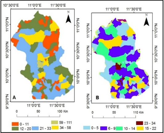
This study develops a Geospatial Governed and Ungoverned Space Index (GGUSI) to systematically identify and analyze governance deficits in Gombe and Taraba States, Nigeria. In response to persistent insecurity in the North-East and Middle Belt regions, the research leverages satellite remote sensing, Geographic Information Systems (GIS), and spatial datasets to quantify state presence and security coverage. The core hypothesis is that governance and security have measurable spatial expressions, shaped by physical terrain, infrastructure distribution, and accessibility. A multi-criteria weighted overlay analysis in ArcGIS integrated key indicators: terrain ruggedness and forest cover (weighted 0.3 each), settlements without security infrastructure (0.2), and settlements lacking schools and health facilities (0.1). Higher composite scores identified areas with pronounced ungoverned characteristics. Data sources included Landsat 9 imagery for land use/land cover classification, ACLED conflict data, and GRID3 datasets on settlements, social infrastructure, and security points. Results reveal distinct spatial patterns. In Gombe State, ungoverned spaces are driven primarily by security gaps and difficult terrain, with critical deficits in wards like Awak (Kaltungo LGA) lacking any police facility. Social infrastructure alone was a weaker predictor. The study concludes that physical geography and security infrastructure are the dominant drivers of ungoverned spaces in these regions. The GGUSI provides a spatially explicit, evidence-based tool for prioritizing security interventions, enhancing resource allocation, and strengthening governance in vulnerable areas. This geospatial approach aligns with national objectives for data-driven security planning and the effective utilization of Nigeria's space-based assets.
References
Adelaja, A. O., Labo, A., & Penar, E. (2018). Public opinion on the root causes of terrorism and objectives of terrorists: A Boko Haram case study. Perspectives on terrorism, 12(3), 35-49.
Adeyemi, O. O. (2021). Geospatial approaches to internal security management in Nigeria. Journal of Security Studies, 14(2), 45–62.
Ahmed, A., Elduma, A., Magboul, B., Higazi, T., & Ali, Y. (2019). The first outbreak of dengue fever in Greater Darfur, Western Sudan. Tropical medicine and infectious disease, 4(1), 43.
Campbell, J. B., & Wynne, R. H. (2011). Introduction to remote sensing (5th ed). Guilford Press.
Clunan, A. L., & Trinkunas, H. A. (2010). Ungoverned spaces: Alternatives to state authority in an era of softened sovereignty. Stanford University Press.
Onuoha, F. C., & Ezirim, G. E. (2013). Terrorism and transnational organised crime in West Africa. Centre for Studies Report.
Goodchild, M. F. (2007). Citizens as sensors: The world of volunteered geography. GeoJournal, 69(4), 211–221.
Longley, P. A., Goodchild, M. F., Maguire, D. J., & Rhind, D. W. (2015). Geographic information systems and science (4th ed). Wiley.
Okoli, A. C., & Ugwu, A. C. (2019). Of Marauders and Brigands: Scoping the threat of rural banditry in Nigeria's North-west. Brazilian Journal of African Studies/Revista Brasileira De Estudos Africanos, 4(8), 201.
Okoli, A. C., & Lenshie, N. E. (2018). Nigeria: Nomadic Migrancy and Rural Violence. Conflict Studies Quarterly, (25), 68.
Onuoha, A. (2020). Land Ownerships, Natural Resources and the Evolution of Conflicts in Nigeria. African Journal of Social Sciences (AJSS), 10, 28-40.
National Space Research and Development Agency (NASRDA). (2020). Nigeria’s space policy and national security framework. Abuja: NASRDA.
United Nations Office for Outer Space Affairs (UNOOSA). (2021). Space solutions for security and sustainable development. United Nations.
Downloads
Published
Issue
Section
Categories
License
Copyright (c) 2026 Buhari Garba, Musa Ibrahim, Yakub Mohammed Tukur, Samaila Abdullahi Samad

This work is licensed under a Creative Commons Attribution 4.0 International License.