
A Review of Remote Sensing and GIS for Integrated Hydrogeological Characterization and Groundwater Dynamics
DOI:
https://doi.org/10.33003/fjs-2026-1017-5815Keywords:
Remote Sensing-GIS Integration, Multi-Sensor Integration, Aquifer Mapping, Groundwater Recharge, Groundwater Storage Change, Land SubsidenceAbstract
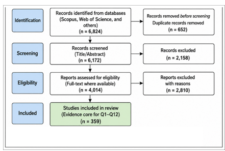
Remote sensing, GIS, field observations, geophysics, and process models are increasingly integrated in groundwater studies, but the hydrogeological significance of multi-sensor integration remains inconsistently defined. This systematic and critical review evaluates four domains: aquifer mapping and hydrogeological characterization (C1), groundwater recharge (C2), groundwater storage change (C3), and groundwater-related land subsidence (C4). A predefined framework separates integration level (I1-I4), sensor diversity (S1-S3+), and hydrogeological coupling (H0-H2), and assesses whether added data streams improve construct validity, uncertainty characterization, independent verification, scale representation, or process understanding. Four Scopus search modules yielded 12,125 records and 10,689 unique identifiers; consolidation produced a master dataset of 10,640 records. Title/abstract screening excluded 3,816 records, leaving 6,824 for eligibility assessment. Final reconciliation retained 4,014 report/study units and excluded 2,810. Detailed Q1-Q12 appraisal and critical inferential synthesis were restricted to 359 primary-source-verified studies; the remaining 3,655 retained records were not treated as fully verified or critically evaluated. The strongest designs moved beyond subjective overlay by integrating independent wells, tracers, hydrogeophysics, geodetic verification, cross-method estimation, uncertainty-aware fusion, and mechanistic coupling between groundwater and hydraulic pressure. Multi-sensor hydrogeology should therefore be judged by inferential gain rather than sensor count. Additional data are scientifically valuable when they provide non-redundant constraints, improve an explicit comparator, extend a key observation dimension, reduce uncertainty, strengthen causal attribution, or bridge a defined gap between process and inference
References
Alghafli, K., Shi, X., Sloan, W., Shamsudduha, M., Tang, Q., Sefelnasr, A., & Ebraheem, A. A. (2023). Groundwater recharge estimation using in situ and GRACE observations in the eastern region of the United Arab Emirates. Science of the Total Environment, 867, 161489. https://doi.org/10.1016/j.scitotenv.2023.161489
Ali, S., Ran, J., Khorrami, B., Wu, H., Tariq, A., Jehanzaib, M., Khan, M. M., & Faisal, M. (2024). Downscaled GRACE/GRACE-FO observations for spatial and temporal monitoring of groundwater storage variations at the local scale using machine learning. Groundwater for Sustainable Development, 25, 101100. https://doi.org/10.1016/j.gsd.2024.101100
Arabameri, A., Rezaei, K., Cerdà, A., Lombardo, L., & Rodrigo-Comino, J. (2019). GIS-based groundwater potential mapping in Shahroud plain, Iran: A comparison among statistical, data-mining and MCDM approaches. Science of the Total Environment, 658, 160–177. https://doi.org/10.1016/j.scitotenv.2018.12.115
Bockstiegel, A., Heße, F., Doummar, J., & Kolditz, O. (2024). Simulation of present and future land subsidence in the Rafsanjan plain, Iran, due to groundwater overexploitation using numerical modeling and InSAR data analysis. Hydrogeology Journal, 32(1), 289–305. https://doi.org/10.1007/s10040-023-02657-y
Castle, S. L., Thomas, B. F., Reager, J. T., Rodell, M., Swenson, S. C., & Famiglietti, J. S. (2014). Groundwater depletion during drought threatens future water security of the Colorado River Basin. Geophysical Research Letters, 41, 5904–5911. https://doi.org/10.1002/2014GL061055
Chaussard, E., Amelung, F., Abidin, H., & Hong, S.-H. (2013). Sinking cities in Indonesia: ALOS PALSAR detects rapid subsidence due to groundwater and gas extraction. Remote Sensing of Environment, 128, 150–161. https://doi.org/10.1016/j.rse.2012.10.015
Chen, B., Gong, H., Li, X., Lei, K., Ke, Y., Duan, G., & Zhou, C. (2016). Imaging land subsidence induced by groundwater extraction in Beijing (China) using satellite radar interferometry. Remote Sensing, 8(6), 468. https://doi.org/10.3390/rs8060468
Coelho, V. H. R., Montenegro, S. M. G. L., Almeida, C. N., Silva, B. B., Oliveira, L. M., Gusmão, A. C. V., Freitas, E. S., & Montenegro, A. A. A. (2017). Alluvial groundwater recharge estimation in semi-arid environment using remotely sensed data. Journal of Hydrology, 548, 1–15. https://doi.org/10.1016/j.jhydrol.2017.02.054
Dai, Y., et al. (2024). Tracking shallow and deep groundwater storage changes in North China Plain with improved fusion method and hybrid spectral analysis approach. Journal of Hydrology, 633, 131001. https://doi.org/10.1016/j.jhydrol.2024.131001
Dehghani, M., Valadan Zoej, M. J., Hooper, A., Hanssen, R. F., Entezam, I., & Saatchi, S. (2013). Hybrid conventional and Persistent Scatterer SAR interferometry for land subsidence monitoring in the Tehran Basin, Iran. ISPRS Journal of Photogrammetry and Remote Sensing, 79, 157–170. https://doi.org/10.1016/j.isprsjprs.2013.02.012
Dekongmen, B. W., et al. (2022). Groundwater recharge estimation and potential recharge mapping in the Afram Plains of Ghana using SWAT and remote sensing techniques. Groundwater for Sustainable Development, 17, 100741. https://doi.org/10.1016/j.gsd.2022.100741
Du, Z., Ge, L., Ng, A. H.-M., Zhu, Q., Zhang, Q., Kuang, J., & Dong, Y. (2019). Long-term subsidence in Mexico City from 2004 to 2018 revealed by five synthetic aperture radar sensors. Land Degradation & Development, 30(15), 1785–1801. https://doi.org/10.1002/ldr.3347
Duffy, C. E., Braun, A., & Hochschild, V. (2020). Surface subsidence in urbanized coastal areas: PSI methods based on Sentinel-1 for Ho Chi Minh City. Remote Sensing, 12(24), 4130. https://doi.org/10.3390/rs12244130
El-Bagoury, K., et al. (2025). Potentiality delineation of groundwater recharge in arid regions using multi-criteria analysis. Water, 17(5), 766. https://doi.org/10.3390/w17050766
El-Hadidy, M. (2024). Towards sustainable development goals: Leveraging multi-data remote sensing fusion for monitoring groundwater-induced bedrock subsidence dynamics in Egypt's Nile Valley. Groundwater for Sustainable Development, 27, 101353. https://doi.org/10.1016/j.gsd.2024.101353
Erban, L. E., Gorelick, S. M., & Zebker, H. A. (2014). Groundwater extraction, land subsidence, and sea-level rise in the Mekong Delta, Vietnam. Environmental Research Letters, 9, 084010. https://doi.org/10.1088/1748-9326/9/8/084010
Gaber, A., Mohamed, A. K., ElGalladi, A., Abdelkareem, M., Beshr, A. M., & Koch, M. (2020). Mapping the groundwater potentiality of West Qena Area, Egypt, using integrated remote sensing and hydro-geophysical techniques. Remote Sensing, 12(10), 1559. https://doi.org/10.3390/rs12101559
Gemitzi, A., Ajami, H., & Richnow, H.-H. (2017). Developing empirical monthly groundwater recharge equations based on modeling and remote sensing data—Modeling future groundwater recharge to predict potential climate-change impacts. Journal of Hydrology, 546, 1–13. https://doi.org/10.1016/j.jhydrol.2017.01.005
Gumma, M. K., & Pavelic, P. (2013). Mapping of groundwater potential zones across Ghana using remote sensing, geographic information systems, and spatial modeling. Environmental Monitoring and Assessment, 185, 3561–3579. https://doi.org/10.1007/s10661-012-2810-y
Ki, I., Chakroun, H., Koussoube, Y., & Zouari, K. (2023). Assessment of aquifer recharge potential using remote sensing, GIS and the analytical hierarchy process combined with hydrochemical and isotope data (Tamassari Basin, Burkina Faso). Water, 15(4), 650. https://doi.org/10.3390/w15040650
Kim, J.-W., Lu, Z., Jia, Y., & Shum, C. K. (2015). Ground subsidence in Tucson, Arizona, monitored by time-series analysis using multi-sensor InSAR datasets from 1993 to 2011. ISPRS Journal of Photogrammetry and Remote Sensing, 107, 126–141. https://doi.org/10.1016/j.isprsjprs.2015.03.013
Li, J., & Ma, J. (2024). Evaluating the dynamics of groundwater storage and its sustainability in the Loess Plateau: The integrated impacts of climate change and human activities. Remote Sensing, 16(23), 4375. https://doi.org/10.3390/rs16234375
Magnoni, P. H. J., Silva, C. O. F., & Manzione, R. L. (2020). Groundwater recharge and water table levels modelling using remotely sensed data and cloud-computing. Sustainable Water Resources Management, 6, 113. https://doi.org/10.1007/s40899-020-00469-6
Maqsoom, A., Aslam, B., Khalid, N., Ullah, F., Anysz, H., Almaliki, A. H., Almaliki, A. A., & Hussein, E. E. (2022). Delineating groundwater recharge potential through remote sensing and geographical information systems. Water, 14(11), 1824. https://doi.org/10.3390/w14111824
McGowan, J., Sampson, M., Salzwedel, D. M., Cogo, E., Foerster, V., & Lefebvre, C. (2016). PRESS peer review of electronic search strategies: 2015 guideline statement. Journal of Clinical Epidemiology, 75, 40–46. https://doi.org/10.1016/j.jclinepi.2016.01.021
Milewski, A., Sultan, M., Yan, E., Becker, R., Abdeldayem, A., Soliman, F., & Abdel Gelil, K. (2009). A remote sensing solution for estimating runoff and recharge in arid environments. Journal of Hydrology, 373(1–2), 1–14. https://doi.org/10.1016/j.jhydrol.2009.04.002
Naghibi, S. A., Pourghasemi, H. R., & Dixon, B. (2016). GIS-based groundwater potential mapping using boosted regression tree, classification and regression tree, and random forest machine learning models in Iran. Environmental Monitoring and Assessment, 188, 44. https://doi.org/10.1007/s10661-015-5049-6
Nainggolan, L., Ni, C.-F., Darmawan, Y., Lo, W.-C., Lee, I.-H., Lin, C.-P., & Hiep, N. H. (2024). Cost-effective groundwater potential mapping by integrating multiple remote sensing data and the index–overlay method. Remote Sensing, 16(3), 502. https://doi.org/10.3390/rs16030502
Page, M. J., McKenzie, J. E., Bossuyt, P. M., et al. (2021). The PRISMA 2020 statement: an updated guideline for reporting systematic reviews. BMJ, 372, n71. https://doi.org/10.1136/bmj.n71
Raju, A., Singh, R. P., Kannojiya, P. K., Patel, A., Singh, S., & Sinha, M. (2024). Declining groundwater and its impacts along Ganga riverfronts using combined Sentinel-1, GRACE, water levels, and rainfall data. Science of the Total Environment, 920, 170932. https://doi.org/10.1016/j.scitotenv.2024.170932
Rehman, A., Xue, L., Islam, F., Ahmed, N., Qaysi, S., Liu, S., Alarifi, N., Youssef, Y. M., & Abd-Elmaboud, M. E. (2024). Unveiling groundwater potential in Hangu District, Pakistan: A GIS-driven bivariate modeling and remote sensing approach for achieving SDGs. Water, 16(22), 3317. https://doi.org/10.3390/w16223317
Rethlefsen, M. L., Kirtley, S., Waffenschmidt, S., et al. (2021). PRISMA-S: an extension to the PRISMA Statement for reporting literature searches in systematic reviews. Systematic Reviews, 10, 39. https://doi.org/10.1186/s13643-020-01542-z
Rodell, M., Velicogna, I., & Famiglietti, J. S. (2009). Satellite-based estimates of groundwater depletion in India. Nature, 460, 999–1002. https://doi.org/10.1038/nature08238
Sangawi, A., Al-Manmi, D. A. M., & Aziz, B. Q. (2023). Integrated GIS, remote sensing, and electrical resistivity tomography methods for the delineation of groundwater potential zones in Sangaw Sub-Basin, Sulaymaniyah, KRG-Iraq. Water, 15(6), 1055. https://doi.org/10.3390/w15061055
Shamseer, L., Moher, D., Clarke, M., et al. (2015). Preferred reporting items for systematic review and meta-analysis protocols (PRISMA-P) 2015: elaboration and explanation. BMJ, 349, g7647. https://doi.org/10.1136/bmj.g7647
Su, K., Zheng, W., Yin, W., Hu, L., & Shen, Y. (2022). Improving the accuracy of groundwater storage estimates based on groundwater weighted fusion model. Remote Sensing, 14(1), 202. https://doi.org/10.3390/rs14010202
Tang, W., Ng, A. H.-M., Wang, H., Kuang, J., & Du, Z. (2024). Surface subsidence characteristics and causes analysis in Ningbo Plain by Sentinel-1A TS-InSAR. Remote Sensing, 16(13), 2438. https://doi.org/10.3390/rs16132438
Zhou, C., Gong, H., Chen, B., Li, J., Gao, M., Zhu, F., Chen, W., & Liang, Y. (2017). InSAR time-series analysis of land subsidence under different land use types in the eastern Beijing Plain, China. Remote Sensing, 9(4), 380. https://doi.org/10.3390/rs9040380
Downloads
Published
Issue
Section
Categories
License
Copyright (c) 2026 Salwan Sabbar Al-Hasnawi, Nada Farook Aboud, Shahad Adil Al-Qaraghuli, Hala Mohammed Al-Sekar

This work is licensed under a Creative Commons Attribution 4.0 International License.