
Detection of Subsurface Structures at Ganmo–Amoyo–Ojoku Nigeria Using High-Resolution Aeromagnetic Data
DOI:
https://doi.org/10.33003/fjs-2026-1013-5692Keywords:
Aeromagnetic Data, Structural Lineaments, Oasis Montaj, Pan African, MineralizationAbstract
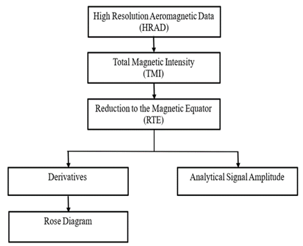
Subsurface structures have their economic importance and play very important role in mineralization such as conduits and loci of deposition. This study is aimed at detecting the structural lineaments that play very important roles in mineralization of Ganmo–Amoyo–Ojoku areas, Southwestern Nigeria. High Resolution Aeromagnetic Data (HRAD) of Ilorin (Sheet 223) was acquired from the Nigerian Geological Survey Agency (NGSA), processed and interpreted using Oasis Montaj software to assess basement configuration and structural disposition of the area. The data were further enhanced using magnetic techniques such as analytic signal (AS), first vertical derivative (FVD) and tilt angular derivative (TDR). Analytic Signal map locates the magnetic source and boundaries of the magnetic bodies ranging from 0.0884 – 0.2249 nT/m around Agun, Ereje, Orogun, Alaya and Apala which could be targets for mineral prospecting. The Tilt Angular Derivative (TDR) determine the orientations of the lineaments in the study area. The extracted lineament map from FVD and TDR suggested the dominance of Pan African and Liberian orogeny with the orientation in NE-SW and NW-SE. This suggests that NE-SW and NW-SE regional fault could be responsible for the mineralization of the area. It is concluded mineral exploration needs to be conducted in the area for further investigation.
References
Abdelouhed, F., Ahmed, A., Abdellah, A., Mohammed, I. & Zouhair, O. (2022). Extraction and analysis of geological lineaments by combining ASTER-GDEM and Landsat-8 image data in the central High Atlas of Morocco. Natural Hazards, 111(2), 1907-1929. https://doi.org/10.1007/s11069 021-05122-9.
Adepoju, M. O., Odeyemi, I. B. & Akinluyi, F. O. (2021). Landsat-8 lineament analysis for detection of epigenetic mineralization zones in parts of Igarra Schist Belt, Southwestern Nigeria. Remote Sensing in Earth Systems Sciences, 4(1), 76-86. https://doi.org/10.1007/s41976-021-00046-1.
Ajibade, A. C., Woakes, M., & Rahaman, M. (1987). Proterozoic crustal development in the Pan-African regime of Nigeria. In A. Kroner (Ed.), Proterozoic lithospheric evolution (pp. 259–271). American Geophysical Union.
Arogundade, A. B., M. O. Awoyemi, O. S. Hammed, S. C. Falade & O. D. Ajama (1999). “Structural investigation of Zungeru-Kalangai fault zone and its environ, Nigeria using aeromagnetic and remote sensing data”, Heliyons 8 2022 e09055. https://doi.org/10.1016/j.heliyon.2022.e09055.
Balogun, O. B. (2019). Tectonic and structural analysis of the Migmatite–Gneiss–Quartzite complex of Ilorin area from aeromagnetic data. NRIAG Journal of Astronomy and Geophysics, 8(1), https://doi.org/10.1080/20909977.2019.1615795.
Barbosa, V. C. F. Silva J. B. C. & W. E Medeiros, “Stability analysis and improvement of structural index estimation in Euler deconvolution” Geophysics 64 48. https://doi.org/10.1190/1.1444529
Cooper, G.R.J. (2006). Interpreting potential field data using continuous wavelet transforms of their horizontal derivatives. Computer Geosciences 32984–992.
Dada, S. S. (1998). Crust-forming ages and Proterozoic crustal evolution in Nigeria: A reappraisal of current interpretations. Precambrian Research, 87(1), 65–74.
Eldosouky, A.M., Abdelkareem M. & Elkhateeb, S.O. (2017). Integration of remote sensing and aeromagnetic data for mapping structural fea tures and hydrothermal alteration zones in Wadi Allaqi area, South Eastern Desert of Egypt. Journal of Africa Earth Sci. Elsevier 130:28–37.
Evjen, H.M. (1936). The place of the vertical gradient in gravitational interpretations. Geophysics. Society of Exploration Geophysicists 1(1): 127–136.
Folorunsho, I. O., Magaji, Y., Ajadi, J. and Issa, U. (2024). Application of Euler and Werner deconvolution techniques in delineating tin deposit in Okeso area, Southwestern, Nigeria. Proc. Niger. Soc. Phys. Sci. 1(96). https://doi.org/10.61298/pnspsc.2024.1.96.
Gunn P. J.& M. C. Dentith (1997). “Magnetic responses associated with mineral deposits AGSO”, Journal of Geology and Geophysics 17 (145).
Hinze W.J., Von-Frese R.R.B., Saad A.H., (2013). Gravity and magnetic exploration: Principles, practices, and applications. Cambridge University Press
Hubbard, B. E., Mack, T. J. and Thompson, A. L. (2012). Lineament analysis of mineral areas of interest in Afghanistan: Automatically delineated lineaments using 30-m TM imagery. U.S. Geological Survey Open-File Report, 1084, 28. http://pubs.usgs.gov/of/2012/1048
Hung, L., Batelaan, O. and de Smedt, F. (2005). Lineament extraction and analysis, comparison of LANDSAT ETM and ASTER imagery. Case study: Suoimuoi tropical karst catchment, Vietnam. Remote Sensing for Environmental Monitoring, GIS Applications, and Geology V, Remote sensing for environmental monitoring, GIS applications, and geology V: 19-20 September 2005, Bruges, Belgium (Proceedings of SPIE - The International Society for Optical Engineering; Vol. 5983). SPIE. https://doi.org/10.1117/12.627699
Ibraheem, I.M., Haggag, M. & Tezkan, B. (2019) Edge detectors as structural imaging tools using aeromagnetic data: a case study of Sohag Area, Egypt. Geosciences. Multidisciplinary Digital Publishing Institute 9(5):211.
Ismaeel, F.O., Yusuf, M., Olarewaju, A.H., Salaudeen, S.A., Obalalu, A.M., Khan, U. and Alsawah, G.A. (2025). Muscovite ore exploration using 3-D Euler deconvolution andtotal horizontal gradient of magnetic anomalies in Eleeku, Northcentral, Nigeria. Z Angew Math Mech. 105, e70247. DOI: https://doi.org/10.1002/zamm.7024.
Javhar, A., Chen, X., Bao, A., Jamshed, A., Yunus, M., Jovid, A. & Latipa, T. (2019). Comparison of multi-resolution optical Landsat-8, Sentinel-2 and Radar Sentinel-1 data for automatic lineament extraction: A case study of Alichur area, SE Pamir. Remote Sensing, 11(7), 778. DOI: https://doi.org/10.3390/rs11070778
Lawal, T.O. & Nwankwo, L.I. (2017). Evaluation of the depth to the bottom of magnetic sources and heat flow from high resolution aeromagnetic (HRAM) data of part of Nigeria sector of Chad Basin. Arab J Geosci:1–12. DOI: https://doi.org/10.1007/s12517-017-3154-2
Liu, C. C., Sousa Jr, M. d. A. & Gopinath, T. R. (2000). Regional structural analysis by remote sensing for mineral exploration, Paraiba State, Northeast Brazil. Geocarto International, 15(1), 70-77. https://doi.org/10.1080/10106040008542142
Magaji, Y. and Sanusi, Y. A. (2021). Evaluation of hydrocarbon prospect in Lema area, western parts of Sokoto Basin, Nigeria, based on analysis of high-resolution aeromagnetic data. Quest Journals Journal of Research in Environmental and Earth Sciences, 7(4), 46–61.
Magaji, Y., Folorunso O. I., Salaudeen, A. S., Olajide, A. T. and Wahab, O. F. (2025a). Structural and Mineralization Mapping of Muscovite Ore Deposit in Eleeku Southwestern, Nigeria. FUDMA Journal of Sciences (FJS), 9(10), 277-289.
Magaji, Y., Folorunso O. I., Wahab, O. F. and Salaudeen, A. S. (2025b). Aeromagnetic Perspectives on Basement Morphology and Depth Beneath Ilorin Metropolis, Southwestern, Nigeria. Dutse Journal of Pure and Applied Sciences (DUJOPAS), 11(4a), 143-153.
Megwara, J.U. and Udensi, E. E. (2013). Lineaments study using aeromagnetic data over parts of southern Bida basin, Nigeria and the surrounding basement rocks. International Journal of Basic and Applied Sciences, 2(1), pp. 115-124.
Miller, H. G. and Singh, V. (1994). Potential field tilt: a new concept for location of potential field sources. Journal of Applied Geophysics 32, 213–217.
Mwaniki, M. W., Matthias, M. S. & Schellmann, G. (2015). Application of remote sensing technologies to map the structural geology of central Region of Kenya. IEEE Journal of Selected Topics in Applied Earth Observations and Remote Sensing, 8(4), 1855-1867. DOI: https://doi.org/10.1109/JSTARS.2015.2395094
Nabighian, M.N. (1972). The analytic signal of two-dimensional magnetic bodies with polygonal cross-section: its properties and use for auto mated anomaly interpretation. Geophysics. Society of Exploration Geophysicists 37(3):507–517.
Oladejo, O. P., T. A. Adagunodo, I. A. Sunmonu, M. A. Adabanija, N. K. Olasunkanmi & N. Omeje, “Structural analysis of subsurface stability using aeromagnetic data: a case of Ibadan, southwestern Nigeria”, Journal of Physics Conference Series 1299 (2019) 012083. https://iopscience.iop.org/article/10.1088/1742-6596/1299/1/012083.
Oladejo, O. P., T. A. Adagunodo, L. A. Sunmonu, M. A. Adabanija, C. A. Enemuwe & P. O. Isibor (2020). “Aeromagnetic mapping of fault architecture along Lagos–Ore axis, southwestern Nigeria”, Open Geosciences 12 376. https://doi.org/10.1515/geo-2020-0100.
Onyewuchi, R.A., Opara, A.I., Ahiarakwem, C.A. and Oko, F. U. (2012). Geological Interpretations Inferred from Airborne Magnetic and Landsat Data: Case Study of Nkalagu Area, Southeastern Nigeria. International Journal of Science and Technology, 2(4) pp. 178-191
Paterson, N. R. and C. V. Reeves (1985) “Applications of Gravity and Magnetic Surveys”Geophysics 50 (1985) 2558. https://doi.org/10.1190/1.1441884.
Phillips JD (2007) Geosoft eXecutables (GX’s) developed by the U.S. Geological Survey, version 2.0, with notes on GX development from Fortran code: U.S. Geological Survey Open-File Report 2007–1355.
Ramli, M., Yusof, N., Yusoff, M., Juahir, H., and Shafri, H. (2010). Lineament mapping and its application in landslide hazard assessment: a review. Bulletin of Engineering Geology and the Environment, 69(2), 215-233. https://doi.org/10.1007/s10064-009-0255-5.
Rahaman, M. A. (1988). Recent advances in the study of the Basement Complex of Nigeria. In Precambrian geology of Nigeria (pp. 11–43). Geological Survey of Nigeria.
Rahaman, M. A. (1989). Review of basement geology of Southwestern Nigeria. In C. A. Kogbe (Ed.), Geology of Nigeria (2nd ed., pp. 39–56). Rock View Ltd.
Saheed, O. & Magaji, Y. (2022). Analysis of High-Resolution Aeromagnetic Data over Parts of Sokoto Basin, North-West Nigeria”, A Journal of Engineering. https://www.researchgate.net/publication/358452877.
Salem, A., Williams, S., Fairhead, J., Ravat, D., & Smith, R. (2007). Tilt depth method: A simple depth estimation method using first-order magnetic derivatives. The Leading Edge, 26, 1502–1505.
Telford, W.M., Geldart LP, Sheriff RE (1990). Applied geophysics. Cambridge University Press
Turner, D. (1983). Upper Proterozoic schist belts in the Nigerian sector of the Pan-African province of West Africa. Precambrian Research, 21(1–2), 55–79.
Verduzco, B., Fairhead, J. D., Green, C. M. & MacKenzie, C (2004). New insights into magnetic derivatives for structural mapping. Lead. Edge 23, 116–119.
Downloads
Published
Issue
Section
Categories
License
Copyright (c) 2026 Folorunso Owolabi Wahab, Jimoh Ajadi, Gabriel Efomeh Omolaiye, Yusuf Magaji, Mudashir Olayiwola Raheem

This work is licensed under a Creative Commons Attribution 4.0 International License.