
Analysis of Spatial Data for Hydrological Modelling of Tiga Dam Watershed, Kano, Nigeria
DOI:
https://doi.org/10.33003/fjs-2026-1018-5477Keywords:
Spatial Data, Hydrological Modelling, GIS, Remote Sensing, Watershed, Tiga DamAbstract
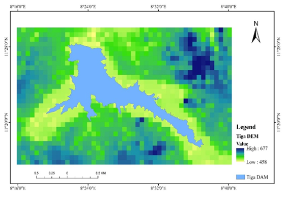
Hydrological modelling depends on reliable spatial datasets that represent watershed terrain, land use/land cover (LULC), soil and drainage characteristics. This study analyzed and prepared spatial datasets for subsequent hydrological modelling of a selected 116.46 km² portion of the Tiga Dam watershed, Kano State, Nigeria, using Geographic Information System (GIS) and remote sensing techniques. A 30 m Shuttle Radar Topography Mission (SRTM) Digital Elevation Model was processed in ArcGIS to derive elevation, slope, flow direction, flow accumulation, drainage networks, and the watershed boundary. Sentinel-2 imagery with 10 m spatial resolution was classified using the Maximum Likelihood supervised classifier into vegetation, agricultural land, built-up area and water body classes. The resulting LULC distribution comprised agricultural land (75.19 km²; 64.56%), vegetation (25.41 km²; 21.82%), water body (13.32 km²; 11.44%), and built-up area (2.54 km²; 2.18%). Accuracy assessment based on 69 validation samples produced 88% overall accuracy and a Kappa coefficient of 0.84. Soil information obtained from OpenLandMap was classified into Hydrologic Soil Groups A–D, while DEM-derived flow characteristics were used to delineate the watershed and its drainage/sub-basin structure. All datasets were spatially harmonized through projection, clipping and resampling. The resulting terrain, LULC, soil and drainage layers provide a documented spatial basis for subsequent watershed and Hydrological Response Unit development. No rainfall–runoff simulation, SWAT calibration or validation was conducted. Therefore, the findings represent spatial characterization and preprocessing outputs not direct hydrological model predictions.
References
Arnold, J. G., Moriasi, D. N., Gassman, P. W., Abbaspour, K. C., White, M. J., Srinivasan, R., Santhi, C., Harmel, R. D., Van Griensven, A., Van Liew, M. W., Kannan, N., & Jha, M. K. (2012). SWAT: Model use, calibration, and validation. Transactions of the ASABE, 55(4), 1491–1508.
Babaremu, K. (2024). Impacts of Land Use and Land Cover Changes on Hydrological Parameters in Savanna Catchments of Northern Nigeria. Journal of Water and Climate Change
Balarabe, M. L., et al. (2025). Impact of Land Use Land Cover Changes Of Flood Risk in the Downstream Communities Tiga Dam watershed. FUDMA Journal of Sciences, Vol. 9 No 11, November 2025 pp 167-177, https://doi.org/10.33003/fjs-2025-0911-4058
Burrough, P. A., McDonnell, R. A., & Lloyd, C. D. (2015). Principles of geographical information system (3rd ed.). Oxford University Press.
Cambell, J. B., & Wynne, R. H. (2011.). Introduction to Remote Sensing (5th ed.) Guilford Press.
Dile et al., 2017Dile, Y. T., Daggupati, P., George, C., Srinivasan, R., & Arnold, J. G. (2017). Introducing a new open-source GIS user interface for the SWAT model. Environmental Modelling & Software, 85, 129–138. https://doi.org/10.1016/j.envsoft.2016.08.004
Foley, J. A., DeFries, R., Asner, G. P., Barford, C., Bonan, G., Carpenter, S. R., ... Snyder, P. K. (2005). Global consequences of land use. Science, 309(5734), 570–574. https://doi.org/10.1126/science.1111772
Gassman, P. W., Reyes, M. R., Green, C. H., & Arnold, J. G. (2007). The Soil and Water Assessment Tool: Historical development, applications, and future research directions. Transactions of the ASABE, 50(4), 1211–1250.
Li, S., Zhang, L., Wang, H., Wang, J., Yang, J., & Chen, X. (2018). The effects of land use change on hydrological processes in a watershed: A review. Catena, 163, 348–357. https://doi.org/10.1016/j.catena.2017.12.004
Mohammed, A., Sadiq, A., & Abdullahi, S. (2021). Rainfall–runoff modelling of Kano catchments using GIS techniques. African Journal of Engineering and Technology, 5(2), 33–45.
Taborton, D. G. (1997). A new method for the determination of flow directions and upslope areas in grid digital elevation models. Water Resources Research, 33(2), 309-319. https://doi.org/10.1029/96WR03137
Tuo, Y., Duan, Z., Disse, M., & Chiogna, G. (2021). Elevation of swat performance I simulating stream flow ad its applicability for watershed management: a review. Water, 13(6), 747. https://doi.org/10.3390/w13060747
Umar, A. (2019). Application of hydrological models in water resources management. Nigerian Journal of Water Resources, 6(1), 21–30.
Wilson, J. P., & Gallant, j. c. (eds.) (2000). Terrain analysis: principles ad applications. John Willy & sons
Downloads
Published
Issue
Section
Categories
License
Copyright (c) 2026 Ibrahim Yakubu Abubakar, Haruna Garba, Abbas Usman

This work is licensed under a Creative Commons Attribution 4.0 International License.