
Spatial Distribution of Major Soil Fertility Indicators in Ussa Local Government Area, Taraba State, Nigeria
DOI:
https://doi.org/10.33003/fjs-2026-1013-5347Keywords:
Soil Fertility Indicators, Spatial Variability, Ordinary Kriging, Nutrient Mapping, Soil pH, Total Nitrogen, Available Phosphorus, Exchangeable PotassiumAbstract
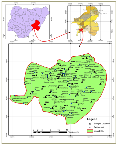
Spatial variability of soil fertility indicators influences nutrient availability and the effectiveness of soil management practices. This study assessed the spatial distribution of major soil fertility indicators in Ussa Local Government Area (LGA), Taraba State, Nigeria. A base map of the study area showing sampling points was generated in ArcGIS using georeferenced coordinates to stratified coverage. The coordinates were uploaded into a GPS and used as waypoints for field sampling. A randomized sub-sampling approach, following the Soils4Africa configuration, was adopted to capture site variability. Soil samples were collected at two depths (0 - 25 cm and 25 - 50 cm), composited to obtain representative samples, yielding 64 samples. Soil pH, total nitrogen (TN), available phosphorus (AvP), and exchangeable potassium (K⁺) were determined using standard laboratory procedures. Ordinary kriging interpolation in ArcGIS 10.5 was used to assess spatial variability and generate nutrient maps. The results revealed considerable spatial variability in the distribution of the investigated soil fertility indicators. Soil pH ranged from 5.56 to 7.50, indicating predominantly slightly acidic to neutral conditions, TN was generally low across the study area, while AvP occurred mainly at medium concentrations with localized low-concentration zones and K+ was predominantly high and relatively uniform across the area. Nutrient concentration maps delineated distinct zones of nutrient sufficiency and deficiency, highlighting areas requiring targeted fertility interventions. The study demonstrates the effectiveness of geostatistical techniques for characterizing soil fertility variability and provides spatial information for site-specific nutrient management, fertilizer optimization, and sustainable agricultural planning in Ussa LGA.
References
Aakash, A., Prasad, J., and Kumar, P. (2021). Spatial variability and mapping of soil fertility parameters using geostatistical techniques. International Journal of Current Microbiology and Applied Sciences, 10(2), 238–248.
Abdullahi, M., and Sadiq, A. A. (2020). Geospatial distribution of some selected soil nutrients in Mubi area, North-Eastern Nigeria. ATBU Journal of Science, Technology and Education. Retrieved from.
Adedeji, O. H. (2019). Geospatial Information as a Tool for Soil Resource Information, Management and Decision Support in Nigeria. Journal of Applied Science and Environmental Management, 23(12)
Afolayan, O. A., Ibitoye, O. O., and Rabiu, A. D. (2020). Digital soil mapping of soil organic carbon of an agricultural watershed in Southwestern Nigeria. Geoderma Regional, 20, e00254.
Akbaş, F., Gunal, H., and Acir, N. (2017). Spatial variability of soil potassium and its relationship to land use and parent material. Soil Water Research, 12(4), 202–209.
Asanarimam, S. A. (2018). A history of Ussa local government area, Lissam, Taraba State, Nigeria. Lissam, Nigeria: Surv. Araen Asanarimam Shinge.
Biradar, S., and Ingle, S. (2023, August). Soil health assessment using biological, physical and chemical indicators. Research Gate
Brady, N. C., and Weil, R. R. (2019). The nature and properties of soils (15th ed.). Pearson Education.
Bünemann, E. K., Bongiorno, G., Bai, Z., Creamer, R. E., De Deyn, G., de Goede, R., ... and Pulleman, M. (2018). Soil quality–A critical review. Soil Biology and Biochemistry, 120, 105-125.
El-Naggar A, Sang Soo Lee, Rinklebe J, Muhammad F, Hocheol So, Sarmah AK, Andrew R. Mahtab A, et al. Ok. Biochar application to low fertility soils: A review of current status, and future prospects. Geoderma. 2019; 337:536-554
Han, L., Lu, Y., Ma, W., and Meng, J. (2022). Spatial patterns of soil organic matter, nitrogen, phosphorus and potassium in a subtropical forest and its implication for forest management. Journal of Resources and Ecology, 13(3), 417–427.
Hengl, T., Leenaars, J. G. B., Shepherd, K. D., Walsh, M., and ISRIC/W GP mapping team. (2017). Soil nutrient maps of Sub-Saharan Africa: Assessment of soil nutrient content at 250 m spatial resolution using machine learning. Nutrient Cycling in Agroecosystems, 109(7), 95–116.
Huang, Z., Wang, M., Ma, H., Zhou, J., and Zhao, J. (2010). Evaluation of digital soil mapping using ordinary kriging with external drift. Geoderma, 155(3-4), 197-209.
Karima, J. (2016). Demographic and socioeconomic characteristics of Ussa Local Government Area, Taraba State. Taraba State Statistical Yearbook.
Keshavarzi, A., Oppong Tuffour, H., Brevik, E. C., Ertunç, G., and Chen, X. (2021). Spatial variability of soil mineral fractions and bulk density in Northern Ireland: Assessing the influence of topography using different interpolation methods and fractal analysis. CATENA, 207.
Kurumaiah, M., Patra, S. S., and Ray, S. K. (2021). Spatial distribution and mapping of soil fertility parameters for site-specific nutrient management. Journal of Soil and Water Conservation, 20(1), 15–21.
Lanki, A. D., Onwu, A. C., Mbashak, R., and Irande, D. (2023). Comparative Study of Tomato (Solanum lycopersicum L.) Cultivation Through Organic and Conventional Farming. Asian J. Res. Crop Sci, 8(4), 255-263.
Mustapha, S., Voncir, N., Umar, S., and Abdulhamid, N. A. (2011). Status and Distribution of some Available Micronutrients in the Haplic usferts of Akko Local Government Area, Gombe State, Nigeria. International Journal of Soil Science, 6(4), 267.
Nalin, R. S., Dalmolin, R. S. D., de Araújo Pedron, F., Moura-Bueno, J. M., Horst, T. Z., Schenato, R. B., and Soligo, M. F. (2023). Accounting for the spatial variation of phosphorus available explained by environmental covariates. Geoderma Regional, 32, e00594.
Obi, M. E., Ezeaku, P. I., and Oguike, S. C. (2018). Variability in potassium status of some soils in southeastern Nigeria. Nigerian Journal of Soil Science, 28(2), 130–138.
Rajamani, K., Hari, N., and Rajashekar, M. (2020). Soil fertility evaluation and GPS-GIS based soil nutrient mapping of Krishi Vigyan Kendra, Palem, Telangana. International Research Journal of Pure and Applied Chemistry, 21(23), 139–145.
Sangya, P. B., Heimsath, A. M., and Slater, L. (2023). Prediction of soil properties across large areas using machine learning with secondary environmental datasets. Geoderma, 415, 115879.
Tijjani, M. A., and David, A. A. (2017). Forms and distribution of potassium along a toposequence on basaltic soils of Vom, Jos Plateau State of Nigeria. International Journal of Environmental and Agricultural Research, 2(1).
Tong, S., Cao, G., Zhang, Z., & Zhang, J. (2023). The spatial variation and driving factors of soil total carbon and nitrogen in the Heihe River source region. Environmental Monitoring and Assessment, 195(6), 724.
Waizah Y., Muhammad Saddiq, A., Ibrahim Solomon, R., Babale Bawa, D., and Abdullahi, M. (2022). Spatial variability of soil organic carbon, total nitrogen and soil pH in soils of Wukari local government area Taraba state, Nigeria. Asian. Journal of Agriculture and Allied Sciences, 5(1), 1-11.
Wang, R., Zou, R., Liu, J., Liu, L., and Hu, Y. (2021). Spatial distribution of soil nutrients in farmland in a hilly region of the Pearl River Delta in China based on geostatistics and the inverse distance weighting method. Agriculture, 11(1), 50.
Wikipedia contributors. (2023, May 22). Ussa. Wikipedia. Retrieved June 21, 2023, from https://poe.com/chat/3d6p01ggxnuhnm1mkg7
Xie, Y., Tang, J., Gao, Y., Gu, Z., Liu, G., & Ren, X. (2023). Spatial distribution of soil erosion and its impacts on soil productivity in Songnen typical black soil region. International Soil and Water Conservation Research, 11(4), 649-659.
Yan, P., Zhou, P., Lei, S., Tan, Z., Chen, H., & Huang, J. (2025). Spatial Distribution of Soil Nutrients in the Red Beds of Southern China and Their Responses to Different Land Use Types. Forests, 16(3), 417.
Yesrebi, J., Saffari Mahboub, H., Fathi, H., Karimian, N., Moazallahi, M., and Gazni, R. (2009). Evaluation and comparison of ordinary kriging and inverse distance weighting method for prediction spatial variability of some soil chemical parameters. Research Journal of Biological Sciences, 4(1), 93–102.
Downloads
Published
Issue
Section
Categories
License
Copyright (c) 2026 Darius Ahmadu Lanki, Clement Alex Onwu, Yakub Waizah, Emmanuel Danladi, Rimamsire Mbashak

This work is licensed under a Creative Commons Attribution 4.0 International License.