
Hydrothermal Mineralization Potential Mapping Using AHP Integration of Airborne Geophysical Data over the Southern Benue Trough, Nigeria
DOI:
https://doi.org/10.33003/fjs-2026-1012-5090Keywords:
Hydrothermal mineralization, Southern Benue Trough, Aeromagnetic data, airborne radiometric data, Analytical Hierarchy Process (AHP)Abstract
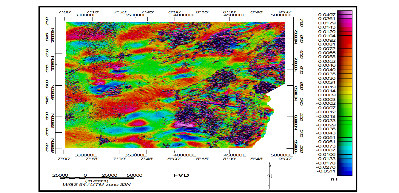
Mineral exploration has gradually shifted from traditional field mapping to integrated geophysical techniques capable of investigating large areas quickly and economically. Hydrothermal mineral deposits are controlled by several geological factors, including faults, fractures, intrusive bodies, hydrothermal alteration, and lithological variations. The Analytical Hierarchy Process (AHP) was employed to delineate the hydrothermal mineralization potential of the Southern Benue Trough, Nigeria, using integrated high-resolution aeromagnetic and airborne radiometric datasets. Advanced geophysical enhancement techniques, like Reduction to the Equator (RTE), First Vertical Derivative (FVD), Analytical Signal (AS), Source Parameter Imaging (SPI), Spectral Analysis, and Centre for Exploration Targeting (CET) grid analysis, were applied to investigate subsurface structures, lithological contacts, intrusive bodies, and basement configurations and depth to magnetic sources. The Analytical Signal map classified the study area into high (>0.0166nT/m), intermediate (0.0093–0.0166 nT/m), and low (<0.0093 nT/m) magnetic zones. High magnetic zones were interpreted as intrusive and structurally disturbed regions associated with hydrothermal activity. SPI depth estimates revealed shallow magnetic source bodies ranging from <0.10 km to >2.7 km, while spectral analysis revealed deeper magnetic source depths ranging from 2.08 km to 9.02 km, with an average depth of 5.01 km. The resulting basement depth model revealed an undulating basement morphology characterized by horsts and grabens that served as depocenters for thick sedimentary accumulations. Structural analysis from the CET grid revealed dominant NE–SW trends with subordinate E–W, WNW–ESE, and NW–SE orientations, reflecting the influence of Pre-Pan-African and Pan-African tectonic events.
References
Abdelrady, M. et al. (2023). Geophysical investigations for the identification of subsurface features influencing mineralization zones. J. King Saud Univ. Sci. 35, 102809.
Abdelrady, M., et al. (2024). Application of aeromagnetic edge detection techniques for mapping structurally controlled mineralisation in Egypt. Journal of King Saud University – Science.
Agocs, W. B. (1951). Least squares residual anomaly determination. Geophysics 16, 686–696.
Akanbi, E. S. & Mangset, W. E. (2011). Structural trends and spectral depth analysis of the residual magnetic field of Naraguta area, North central, Nigeria. Indian J. Sci. Technol. 4, 1410–1415.
Akande S. O., Mücke A., & Eisenlohr B. N. (1988). Genesis of lead–zinc–barite mineralisation in the Benue Trough, Nigeria. Mineralium Deposita, 23, 231–239.
Akande, S. O., & Abimbola, A. F. (1987). Aspects of the genesis of lead-zinc-fluorite-barite mineralization in the Benue Trough, Nigeria. Mineralium Deposita, 22(2), 103–110.
https://doi.org/10.1007/BF00204356.
Akingboye, A. S., et al. (2025). Magneto–radiometric and geochemical mapping of gold mineralisation in southwestern Nigeria. ScienceDirect.
Allek, K., Boubaya, D., Bouguern, A. & Hamoudi, M. Spatial association analysis between hydrocarbon fields and sedimentary residual magnetic anomalies using Weights of Evidence: An example from the Triassic Province of Algeria. J. Appl. Geophy. 135.
Anudu, G. K., Stephenson, R. A., & Macdonald, D. I. M. (2014). Using high-resolution aeromagnetic data to recognize and map intra-sedimentary volcanic rocks and structures in the Cretaceous Benue Trough, Nigeria. Journal of African Earth Sciences, 99, 625–636. https://doi.org/10.1016/j.jafrearsci.2014.06.014.
Arabameri, A., Saha, S., Roy, J., Tiefenbacher, J. P., Cerda, A., & Bui, D. T. (2021). Spatial modeling of mineral prospectivity using machine learning and multi-criteria decision-making approaches. Geocarto International, 36(20), 2307–2330, https://doi.org/10.1080/10106049.2020.1716751.
Benkhelil, J. (1989). The origin and evolution of the Cretaceous Benue Trough (Nigeria). Journal of African Earth Sciences, 8(2–4), 251–282. https://doi.org/10.1016/S0899-5362(89)80028-4.
Blakely, R.J., and Simpson, R.W., (1986) Approximating edges of source bodies from magnetic or gravity anomalies, Geophysics, v. 51, p. 1494-1498.
Bonham-Carter, G. F. (1994). Geographic information systems for geoscientists: Modelling with GIS. Pergamon.
Burke, K., Dessauvagie, T. F. J., & Whiteman, A. J. (1971). The opening of the Gulf of Guinea and the geological history of the Benue Depression and Niger Delta. Nature Physical Science, 233(38), 51–55. https://doi.org/10.1038/physci233051a0.
Carranza, E. J. M. (2019). Geochemical anomaly and mineral prospectivity mapping in GIS. Elsevier. https://doi.org/10.1016/C2015-0-01875-7.
Dentith, M. C., Frankcombe, K. F., & Trench, A. (1994). Geophysical signatures of Western Australian mineral deposits: An overview. AGSO Journal of Australian Geology & Geophysics, 15(4), 125–138.
Dentith, M., & Mudge, S. T. (2014). Geophysics for the mineral exploration geoscientist. Cambridge University Press. https://doi.org/10.1017/CBO9781139024358.
Eldosouky, A. M., Abdelkareem, M., Elkhateeb, S. O., & Sultan, S. A. (2022). Structural analysis and basement topography of Gabal Shilman area, southeastern Desert of Egypt, using aeromagnetic data. Journal of King Saud University – Science, 34(3), Article 101764.
https://doi.org/10.1016/j.jksus.2021.101764.
Elkhateeb, S. O., & Abdellatif, M. A. (2018). Delineation of hydrothermal alteration zones using airborne gamma-ray spectrometry data: A case study from Egypt. Journal of African Earth Sciences, 147, 34–45. https://doi.org/10.1016/j.jafrearsci.2018.06.006.
Encyclopaedia Britannica (updated 2026): “The Industrial Revolution involved the use of new basic materials, chiefly iron and steel…” Explor. Geophys. 25, 103–160 (1994).
EY Report (2023): Coal, iron ore, and steel are critical for economic development and form the backbone of modern industrial systems.
Farrington, J. L. (1952). A preliminary description of the Nigerian lead-zinc field. Economic Geology, 47(6), 583–608. https://doi.org/10.2113/gsecongeo.47.6.583
Feizizadeh, B., & Blaschke, T. (2013). GIS-multicriteria decision analysis for landslide susceptibility mapping: Comparing three methods for the Urmia Lake Basin, Iran. Natural Hazards, 65(3), 2105–2128. https://doi.org/10.1007/s11069-012-0463-3.
Gabtni, H. & Jallouli, C. (2017). Regional-residual separation of potential field: An example from Tunisia. J. Appl. Geophy. 137, 8–24.
Gibert, D., & Galdeano, A. (1985). A computer program to perform transformations of gravimetric and magnetic data. Computers & Geosciences, 11(4), 553–588. https://doi.org/10.1016/0098-3004(85)90005-6.
Holden, E. J., Dentith, M. & Kovesi, P. Towards the automated analysis of regional aeromagnetic data to identify regions prospective for gold deposits. Comput. Geosci. 34, 1505–1513 (2008).
Holden, E.-J. et al. Automated identification of magnetic responses from porphyry systems. ASEG Extend. Abstracts 2010, 1–4 (2010).
Holden, E.-J. et al. Detection of regions of structural complexity within aeromagnetic data using image analysis. in 2010 25th International Conf. of Image and Vision Computing New Zealand 1–8 (IEEE, 2010).
Holden, E.-J., Dentith, M., Kovesi, P., & Grose, L. (2012). Towards the automated analysis of regional aeromagnetic data to identify regions prospective for gold deposits. Computers & Geosciences, 38(1), 1–14. https://doi.org/10.1016/j.cageo.2011.05.007
Hoover, D. B., Pierce, H. A., & Adams, S. S. (1992). Introduction to applied geophysics. In H. L. Barnes (Ed.), Geochemistry of hydrothermal ore deposits (2nd ed., pp. 73–96). Wiley.
IAEA. (2003).Guidelines for radioelement mapping using gamma ray spectrometry data. International Atomic Energy Agency.
IAEA. (2021). Airborne gamma ray spectrometer surveying (Technical Reports Series No. 323, Rev. 1). International Atomic Energy Agency. https://www.iaea.org/publications.
International Atomic Energy Agency (2021). Airborne gamma ray spectrometry in mineral exploration. Vienna: IAEA.
Kovesi, P. (1999). Image features from phase congruency. Videre J. Comput. Vis. Res. 1, 1–26
Leu, L. K. (1981). Use of reduction-to-equator process for magnetic data interpretation. Geophysics, 46(4), 445–454. https://doi.org/10.1190/1.1441207.
Leu, L.-K. (1982).Use of reduction-to-the-equator process for magnetic data interpretation. in Geophysics vol. 47 445 (Soc Exploration Geophysicists 8801 S YALE ST, TULSA, OK 74137.
Li, Y. & Oldenburg, D. W. (2001).Stable reduction to the pole at the magnetic equator. Geophysics 66, 571–578.
Maurice, Z. E. O., Arsène, M., Moustapha, N. N. M., Alain, Z. A. & Herve, G. D. Mapping gold mineralization targets using geological field and magnetic ground data in the yopa area, adamawa-Cameroon. Pure Appl. Geophys. 45, 1–17 (2023).
Miller, H. G., & Singh, V. (1994). Potential field tilt—a new concept for location of potential field sources. Journal of Applied Geophysics, 32(2–3), 213–217. https://doi.org/10.1016/0926-9851(94)90022-1.
Minty, B. R. S. (2023). Airborne gamma-ray spectrometry: Principles, processing and interpretation. Exploration Geophysics, 54(2), 95–112. https://doi.org/10.1080/08123985.2023.2171094.
Nabighian, M. N. (1972). The analytic signal of two-dimensional magnetic bodies with polygonal cross-section: Its properties and use for automated anomaly interpretation. Geophysics 37, 507–517.
Nabighian, M. N., Grauch, V. J. S., Hansen, R. O., et al. (2005). The historical development of the magnetic method in exploration. Geophysics, 70(6), 33ND–61ND. https://doi.org/10.1190/1.2133784.
Nigerian Geological Survey Agency (2022). High-resolution aeromagnetic and radiometric data interpretation of the Benue Trough. Abuja: NGSA.
Nigerian Geological Survey Agency. (2022). Geological and mineral resources map of Nigeria. Nigerian Geological Survey Agency (NGSA).
Núñez-Demarco, P., Bonilla, A., Sánchez-Bettucci, L. & Prezzi, C. Potential-field filters for gravity and magnetic interpretation: A review. Surv. Geophys. 44, 603–664 (2023).
Nwajide C. S. (2013). Geology of Nigeria’s Sedimentary Basins. Lagos: CSS Bookshops.
Nwajide, C. S. (2013). Geology of Nigeria’s sedimentary basins. CSS Press.
Obaje, N. G. (2009). Geology and mineral resources of Nigeria. Springer. https://doi.org/10.1007/978-3-540-92685-6.
Obiora S. C., Chukwu, A., & Nwosu, J. (2015). Geochemical and geophysical constraints on Pb–Zn mineralisation in the Lower Benue Trough, Nigeria. Journal of African Earth Sciences, 107, 1–12.
Obiora, D. N., Ossai, M. N., & Ibuot, J. C. (2019). Interpretation of high-resolution aeromagnetic data over parts of the Lower Benue Trough, southeastern Nigeria, using enhanced filtering techniques. Journal of African Earth Sciences, 154, 47–58.M https://doi.org/10.1016/j.jafrearsci.2019.03.012
Ofoegbu C. O. (1985). Interpretation of aeromagnetic anomalies over the Benue Trough, Nigeria. Journal of African Earth Sciences, 3(3), 307–315.
Ogunsanwo, F. O., et al. (2025). Empirical and spatial relation between magnetic and radiometric survey over mica schist area, Ogun State, Nigeria. FUDMA Journal of Sciences.
Oha, I. A., & Ekwueme, B. N. (2015). Structural interpretation of aeromagnetic data over the Lower Benue Trough, southeastern Nigeria. International Journal of Geosciences, 6(10), 1204–1218. https://doi.org/10.4236/ijg.2015.610096.
Oha, I. A., Ekwueme, B. N., & Onuoha, K. M. (2016). Interpretation of aeromagnetic data over the Southern Benue Trough, southeastern Nigeria. Journal of African Earth Sciences, 119, 1–12.
Ohaegbuchu, H. E., et al. (2026). Geological interpretation of airborne radiometric data for mineral exploration potential. Nigerian Journal of Physics.
Olade, M. A. (2021). Mineral Deposits and Exploration Potential of Nigeria.
Osinowo, O. O., Alumona, K. & Olayinka, A. I. (2020). Analyses of high resolution aeromagnetic data for structural and porphyry mineral deposit mapping of the Nigerian younger granite ring complexes, North-Central Nigeria. J. Afr. Earth Sci. 162, 103705.
Oyeniyi, T. O., Salami, A. A. & Ojo, S. B. Magnetic surveying as an aid to geological mapping: A case study from Obafemi Awolowo University Campus in Ile-Ife, Southwest Nigeria. Ife J. Sci. 18, 331–343 (2016).
Payne Institute (2024): Highlights the continuing importance of iron ore resources in national industrial competitiveness and global markets.
Rahaman, M. A. (1988). Recent advances in the study of the Basement Complex of Nigeria. In P. O. Oluyide, W. C. Mbonu, A. E. Ogezi, I. G. Egbuniwe, A. C. Ajibade, & A. C. Umeji (Eds.), Precambrian geology of Nigeria (pp. 11–43). Geological Survey of Nigeria.
Reyment, R. A. (1965). Aspects of the geology of Nigeria. Ibadan University Press.
Roest, W. R., Verhoef, J., & Pilkington, M. (1992). Magnetic interpretation using the 3-D analytic signal. Geophysics, 57(1), 116–125. https://doi.org/10.1190/1.1443174
Saaty, T. L. (1980). The analytic hierarchy process. McGraw-Hill.
Saaty, T. L. (2008). Decision making with the analytic hierarchy process. International Journal of Services Sciences, 1(1), 83–98. https://doi.org/10.1504/IJSSCI.2008.017590
Salem, A., Williams, S., Fairhead, J. D., Smith, R., & Ravat, D. (2007). Interpretation of magnetic data using tilt-angle derivatives. Geophysics, 72(1), L1–L10. https://doi.org/10.1190/1.2399454.
Thurston, J.B., and Smith, R.S., 1997, Automatic conversion of magnetic data to depth, dip and susceptibility comntrast using the SPITM method, Geophysics, v. 62, p. 807-813.
Uyanık, N. A. (2022). Evaluation of airborne radiometric data for lithological discrimination and hydrothermal alteration mapping. Arabian Journal of Geosciences, 15(12), 1–15.
https://doi.org/10.1007/s12517-022-10345-7.
Vacquier, V., Steenland, N. C., Henderson, R. G., & Zietz, I. (1951). Interpretation of aeromagnetic maps. Geological Society of America Memoirs, 47, 1–151. https://doi.org/10.1130/MEM47-p1
Yousefi, M., & Carranza, E. J. M. (2020). Prediction-area (P–A) plot and multicriteria decision-making for mineral prospectivity mapping. Natural Resources Research, 29(2), 1023–1046. https://doi.org/10.1007/s11053-019-09507-5.
Downloads
Published
Issue
Section
Categories
License
Copyright (c) 2026 Okenu Stella, Olatunji S. Ayaninnuola, Abu Mallam

This work is licensed under a Creative Commons Attribution 4.0 International License.