
INVESTIGATION OF MINERAL DEPOSIT SUSING AEROMAGNETIC DATA IN PART OF NORTH CENTRAL NIGERIA
DOI:
https://doi.org/10.33003/fjs-2026-1005-5004Keywords:
Basement, Structures, Spectral, Airborne Magnetics, LineamentsAbstract
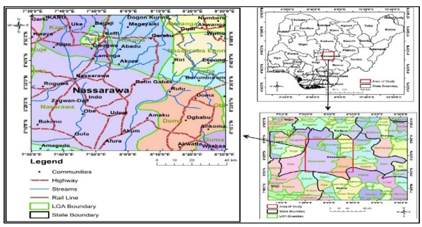
Karu and its surroundings are located in North Central Nigeria, within the middle belt of the Benue trough. This study analyzes high-resolution aeromagnetic data to provide insights into magnetic sources, structures, and potential mineralization zones in the area. The Total Magnetic Intensity data was examined using both qualitative and quantitative techniques, including reduced to equator, residual regional separation, First Vertical Derivative, Horizontal Derivative, Analytical Signal, and Source Parameter Imaging (SPI).Findings from the First Vertical Derivative and Analytical Signal maps indicate various structures with pronounced NE-SW trends, attributed to mega faults near Udeni, NE Brumburum, and NW Gofa. These areas display high structural intensity within sedimentary formations (sandstone, shale) and deep SPI depths, suggesting potential for base metals like lead and zinc, along with iron oxides.Depth estimations through SPI reveal that deep magnetic sources range from -46.352 to 90.252 nT, while shallow sources vary from -59.883 to 89.580 nT. The band pass analysis and integrated data from source parameter imaging and structural density delineate litho-structural controls on mineralization.High-priority zones identified include Uke, Gudi, Magayaikai, Keffi, Akwanga, Nasarawa, Garaku, and Bagaji, with Uke showing significant structural intensity, shallow SPI depths (~85.432 m), and notable geophysical anomalies.
References
Adamu, B. S., Nuhu, D. U., & Abdulhakim, U. S. (2026). Geology And Petrography Of Rocks
Around Butawa, Kafin Magaji And Environs, Part Of Sheet 79ne Northwestern Nigeria.
Fudma Journal Of Sciences, 10(4), 37-44. https://doi.org/10.33003/
Adetona, A.A., Udensi, E.E. and Agelaga A.G. (2007): Determination of depth to buried magnetic rocks under the lower Sokoto Basin, Nigeria, using Aeromagnetic Data. Nigerian Journal of Physics, 19(2). P. 325.
Agbata, P. C., 1989. Gypsum in the Dukamaje and Dange Formations of the Rima River, Sokoto Basin. M.Sc. Dissertation, A. B. U. Zaria, pp.42-48.
Blakely, R.J. and Simpson, R.W. (1986). Approximating edges of source bodies from magnetic or gravity anomalies. Geophysics, 51:1494-1498.
Blakely, R. J. (1995). Potential Theory in Gravity and Magnetic Applications. Cambridge
University Press
Campbell, W.C. (2000). Introduction to geomagnetic fields. Cambridge University Press, Cambridge.
Chemin, J. Y., Desjardins, B, Gallagher, I., Grenier, E. (2006). Mathematical geophysics: an introduction to rotating fluids and the Navier-Stokes equations. Oxford lecture series in mathematics and its applications. Oxford University Press. Pp. 9 – 12
Clark, D. A. (1997). Magnetic petrophysics and magnetic petrology: Aids to geological interpretation of magnetic surveys. Australasian Institute of Mining and Metallurgy Publication Series, 2/97, 119–146.
Nabighian, M. N., et al. (2005). The historical development of the magnetic method in exploration.
Ofoegbu, C.O. and Onuoha, K.M. (1991). Analysis of magnetic data over the Abakaliki Anticlinorium of the Lower Benue Trough, Nigeria. Marine and Petroleum Geology, 8:174-183.
Olasehinde, O.D. (2009). Investigation of the Geothermal Source Potential of part of the Niger-Delta Nigeria using Aeromagnetic Data. Unpublished M. Tech Thesis, Federal University of Technology, Minna, Niger, Nigeria. Pp. 34-44
Geophysics, 7 0(6), 33ND–61ND. https://library.seg.org/doi/10.1190/1.2133784
Reeves, C.V. ( 2005). Aeromagnetic Surveys Principles, Practice and Interpretation, Geosoft.
Salako, K. A. (2023). Geophysical assessment for gold mineralization potential over the southern
Parts of Kebbi State using aeromagnetic data. Academia.edu https://www.academia.edu
/101023456/Geophysical_assessment_for_gold_mineralization_potential over the
southern_part_of_Kebbi_State_using_aeromagnetic_data
Spector, A. and Grant, F.S. (1994). Statistical models for interpreting aeromagnetic data; Geophysics, vol.35; pp 293-302.
Steven, E. J. Adepitan, A. E.& Suleiman, A. (2018). Geological and mineralization expression of
hosted mineralization of Keffi Sheet 208 NE. American Journal of Modern physical and
Application, 5(4), 53–69. http://www.openscienceonline.com/journal/ajmpa
Telford, W.M. Geldart I.P, Sheriff, R.F and Keys D.A. (1976) Applies Geophysisc First Edition.
Cambridge University Press, Cambridge.
Downloads
Published
Issue
Section
Categories
License
Copyright (c) 2026 Augustine Nnabuike Ugwu, Samuel Olatunji Ayanninnuola, Chigozie Stella Okenu

This work is licensed under a Creative Commons Attribution 4.0 International License.

