
ASSESSMENT OF FLOOD RISK AND ADAPTATION STRATEGIES IN HADEJIA RIVER BASIN, NIGERIA
DOI:
https://doi.org/10.33003/fjs-2026-1002-4661Keywords:
Flood-Risk, Adaptation, GIS and Multi-criteria Decision AnalysisAbstract
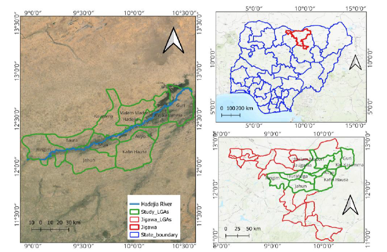
This study evaluates the impact of land use and land cover changes on flood occurrences, highlighting the interplay between environmental modifications and flood dynamics. Additionally, the study employs Multi-Criteria Decision Analysis (MCDA) to predict and map flood risk scenarios, providing a robust framework for risk assessment. The research further examines the rural communities' responses and adaptation strategies, evaluating the effectiveness of local measures and overall community resilience. The study employed a three-phase field reconnaissance survey conducted between August 2023 and January 2024 to collect baseline data. Both primary and secondary data sources were utilized. Primary data included satellite imagery and GPS coordinates, while secondary data comprised topographic and soil maps, hydrological records, and historical rainfall data. Various data processing and analytical techniques, such as image pre-processing, classification, and MCDA, were employed to generate accurate flood risk maps and assess the impact of different contributing factors. The results revealed varying levels of susceptibility. Nearly half of the study area (46.54%) falls under the Very Low-Risk category, suggesting the effectiveness of current flood prevention measures. Low-risk zones account for 19.86%, requiring only basic management interventions, while Moderate-risk areas (18.60%) necessitate improved planning and mitigation strategies. High-Risk regions (11.23%) are highly vulnerable to severe flooding and demand significant intervention, whereas Very High-Risk areas (3.76%) require urgent emergency response measures.
References
Adams, T., Chen, S., Davis, R., Schade, T., & Lee, D. (2010, November). The Ohio river community HEC-RAS model. In World Environmental and Water Resources Congress 2010: Challenges of Change (pp. 1512-1523).
Abubakar, A., Sani, M., Ahmad, M, H., & Gambo, J. (2025). Geospatial Flood Risk Mapping and Vulnerability Assessment using GIS AND AHP in Hadejia River Basin, Jigawa State, Nigeria. FUDMA Journal of Sciences (FJS), 9(12), 793 – 804. DOI: https://doi.org/10.33003/fjs-2025-0912-4323
Adeoye, A. S. (2024). Inclination of Residents' Access to Flood Management Interventions and Forestry Land Use Approaches in Contiguous Floodplains of South-Western Nigeria. Journal of forest and environmental science, 319-329
Adger, W. N., Quinn, T., Lorenzoni, I., Murphy, C., & Sweeney, J. (2013). Changing social contracts in climate-change adaptation. Nature Climate Change, 3(4), 330-333.
Adiat, K. A. N., Nawawi, M. N. M., & Abdullah, K. (2012). Integration of geographic information system and 2D imaging to investigate the effects of subsurface conditions on flood occurrence. Modern Applied Science, 6(3), 11
Ajibade, F. O., Ajibade, T. F., Idowu, T. E., Nwogwu, N. A., Adelodun, B., Lasisi, K. H., ... & Adewumi, J. R. (2021). Flood‐prone area mapping using GIS‐based analytical hierarchy frameworks for Ibadan city, Nigeria. Journal of Multi‐Criteria Decision Analysis, 28(5-6), 283-295
Aladejana, O., Salami, A. T., & Adetoro, O. O. (2021). Potential flood hazard zone mapping based on geomorphologic considerations and fuzzy analytical hierarchy model in a data scarce West African basin. Geocarto International, 36(19), 2160-2185
Alfa, M. I., Ajibike, M. A., & Daffi, R. E. (2018). Application of analytic hierarchy process and geographic information system techniques in flood risk assessment: a case of Ofu river catchment in Nigeria. Journal of Degraded and Mining Lands Management, 5(4), 1363
Babati, A. H., Abdussalam, A. F., Baba, S. U., & Isa, Z. (2022). Prediction of flood occurrences and magnitude in Hadejia-Jama’are river basin, Nigeria. Sustainable Water Resources Management, 8(6), 188
Birkmann, J., Truedinger, A., & Schuettrumpf, H. (2025). The Impact of Science: Uptake of Scientific Recommendations After Extreme Events—Case Study Floods in 2021 in Germany. Journal of Flood Risk Management, 18(3), e70100
Brody, S., Blessing, R., Sebastian, A., & Bedient, P. (2014). Examining the impact of land use/land cover characteristics on flood losses. Journal of Environmental Planning and Management, 57(8), 1252-1265
Bullock, A., & Acreman, M. (2003). The role of wetlands in the hydrological cycle. Hydrology and Earth system sciences, 7(3), 358-389
Calder, I. R., & Aylward, B. (2006). Forest and floods: Moving to an evidence-based approach to watershed and integrated flood management. Water International, 31(1), 87-99
Dolui, S., & Sarkar, S. (2023). Modelling landuse dynamics of ecologically sensitive peri-urban space by incorporating an ANN cellular automata-Markov model for Siliguri urban agglomeration, India. Modeling Earth Systems and Environment, 1-33
Dolui, S., & Sarkar, S. (2023). Site suitability analysis for new urban development using fuzzy-AHP and DEMATEL method: a case of mixed agricultural-urbanized landscape of Burdwan town, West Bengal,(India). In Urban environment and smart cities in Asian Countries: insights for social, ecological, and technological sustainability (pp. 389-423). Cham: Springer International Publishing
Dutta, P., & Deka, S. (2024). Assessment of flood disaster and management strategies in the lower Brahmaputra valley of Assam. Bulletin of Geography. Physical Geography Series, (26), 5-18
Evers, M., Jonoski, A., Almoradie, A., & Lange, L. (2016). Collaborative decision making in sustainable flood risk management: A socio-technical approach and tools for participatory governance. Environmental Science & Policy, 55, 335-344
Fernández, D. S., & Lutz, M. A. (2010). Urban flood hazard zoning in Tucumán Province, Argentina, using GIS and multicriteria decision analysis. Engineering Geology, 111(1-4), 90-98
Few, R. (2013). Flood hazards, vulnerability and risk reduction. In Flood hazards and health (pp. 8-27). Routledge
Ghapar, A. A., Yussof, S., & Bakar, A. A. (2018). Internet of Things (IoT) architecture for flood data management. International journal of future generation communication and networking, 11(1), 55-62
Gutman, S. I., Sahm, S. R., Benjamin, S. G., Schwartz, B. E., Holub, K. L., Stewart, J. Q., & Smith, T. L. (2004). Rapid retrieval and assimilation of ground based GPS precipitable water observations at the NOAA Forecast Systems Laboratory: Impact on weather forecasts. Journal of the Meteorological Society of Japan. Ser. II, 82(1B), 351-360
Ibitoye, M. O., Komolafe, A. A., Adegboyega, A. A. S., Adebola, A. O., & Oladeji, O. D. (2020). Analysis of vulnerable urban properties within river Ala floodplain in Akure, Southwestern Nigeria. Spatial Information Research, 28(4), 431-445
Ibrahim, S. A., & Balzter, H. (2024). Evaluating flood damage to paddy rice fields using PlanetScope and sentinel-1 Data in North-Western Nigeria: towards potential climate adaptation strategies. Remote Sensing, 16(19), 3657
Idowu, D., & Zhou, W. (2021). Land use and land cover change assessment in the context of flood hazard in Lagos State, Nigeria. Water, 13(8), 1105
Idris, S. (2020). Effect of Long-Term Flooding and Landuse Under Different Soil Types: On Selected Soil and Groundwater Properties Of Hadejia-Nguru Wetland, Nigeria. LAP Lambert Academic Publishing
IPCC, (2012). In: Field, C.B., Barros, V., Stocker, T.F., Qin, D., Dokken, D.J., Ebi, K.L., Mastrandrea, M.D., Mach, K.J. (Eds.), Managing the Risks of Extreme Events and Disasters to Advance Climate Change Adaptation: Special Report of the Intergovernmental Panel on Climate Change. 582 pp
Javan, P., Mirzaee, M., & Jabbari, I. (2011). Determination of RiversFlood Plain Risks Level by Multi Criteria Decision Making. Journal of Hydraulics, 6(2), 15-29
Jigawa State Ministry of Agriculture (2013). Medium Term Sector Strategy (MTSS) 2014-2016. Ministry of Agriculture Supported by SPARC ©2013
Kamal, A., Abdullahi Shamsudden, L. M. A., & Aminu, M. U. (2024). Flood Impact Assessment on the Environment: A Case Study of Birnin-Kudu, Jigawa State, Nigeria. J Environ Hazard, 8(04)
Kenyi, M. G. S. (2024, June). Check for updates Evaluation of Sentinel-1 GRD Data with GEE for Floods Mapping in Rubkona, South Sudan. In Information Technology in Disaster Risk Reduction: 8th IFIP WG 5.15 International Conference, ITDRR 2023, Tokyo, Japan, December 4–6, 2023, Revised Selected Papers (Vol. 706, p. 238). Springer Nature.
Komolafe, A. A., Adegboyega, S. A. A., & Akinluyi, F. O. (2015). A review of flood risk analysis in Nigeria. American journal of environmental sciences, 11(3), 157
Kundzewicz, Z. W., Kanae, S., Seneviratne, S. I., Handmer, J., Nicholls, N., Peduzzi, P., ... & Sherstyukov, B. (2014). Flood risk and climate change: global and regional perspectives. Hydrological Sciences Journal, 59(1), 1-28
Lawal, J. O., Buba, F. N., & Awe-Peter, H. (2024). Assessment of the Impact of Land Use and Land Cover Change on the Surface Runoff of Hadejia River System, Kano, Nigeria. International Journal of Latest Technology in Engineering, Management & Applied Science, 13(5), 130-141
Majeed, M., Lu, L., Anwar, M. M., Tariq, A., Qin, S., El-Hefnawy, M. E., ... & Alasmari, A. (2023). Prediction of flash flood susceptibility using integrating analytic hierarchy process (AHP) and frequency ratio (FR) algorithms. Frontiers in Environmental Science, 10, 1037547
McCulloch, J. S. G. (2007). All our yesterdays: a hydrological retrospective. Hydrology and Earth System Sciences, 11(1), 3-11
McShane, M. K., & Yusuf, J. E. (2019). Toward better management of flood losses: flood insurance in a wetter world. Public Works Management & Policy, 24(1), 88-109
Nabara, I. S., Man, N., Kamarulzaman, N. H., & Sulaiman, Z. (2021). Smallholder oil palm farmers’ pro-adaptation behaviour under climate impact scenario: application of protection Motivation Theory. Climate and development, 13(6), 475-483
Nones, M., & Caviedes‐Voullième, D. (2020). Computational advances and innovations in flood risk mapping. Journal of Flood Risk Management, 13(4)
NPC, (2006). Estimated Population Figures National Population Commission of Nigeria, Abuja. Retrieved on March 6, 2015 from www.population.gov.ng
Nwilo, P. C., Olayinka, D. N., & Adzandeh, A. E. (2012). Flood modelling and vulnerability assessment of settlements in the Adamawa state floodplain using GIS and cellular framework approach. Global Journal of Human Social Science, 12(3), 11-20
Nyarko, B. K. (2000). Flood risk zoning of Ghana: Accra experience
Ologunorisa, T. E., and M. J. Abawua. "Flood risk assessment: a review." (2005)
Olusegun, A. T. (2023). Challenges and Potential Solutions to Pluvial Flood Risk in Urban Tropical African Communities a Case Study Using Ijebu-Ode in South West Nigeria (Doctoral dissertation, The University of Liverpool (United Kingdom))
Ouma, Y. O., & Tateishi, R. (2014). Urban flood vulnerability and risk mapping using integrated multi-parametric AHP and GIS: methodological overview and case study assessment. Water, 6(6), 1515-1545
Pathan, S., Kumar, P., Pai, R. M., & Bhandary, S. V. (2021). Automated segmentation and classifcation of retinal features for glaucoma diagnosis. Biomedical Signal Processing and Control, 63, 102244
Paul, M. J., Meyer, J. L., & Couch, C. A. (2006). Leaf breakdown in streams differing in catchment land use. Freshwater Biology, 51(9), 1684-1695
Paul, S., & Ghosh, S. (2022). Identification of solid waste dumping site suitability of Kolkata Metropolitan Area using Fuzzy-AHP model. Cleaner Logistics and Supply Chain, 3, 100030
Penning-Rowsell, E. C., Priest, S., & Johnson, C. (2014). The evolution of UK flood insurance: incremental change over six decades. International Journal of Water Resources Development, 30(4), 694-713
Saaty, R. W. (1987). The analytic hierarchy process—what it is and how it is used. Mathematical modelling, 9(3-5), 161-176
Salihu, M., Wudil, A. H., Katanga, Y. N., & Auwal, A. M. (2022). Economic analysis of date palm marketing in Jigawa state–Nigeria. International Journal of Intellectual Discourse, 5(4), 229-243
Seejata, K., Yodying, A., Chatsudarat, S., Chidburee, P., Mahavik, N., Kongmuang, C., & Tantanee, S. (2019). Assessment of flood hazard using geospatial data and frequency ratio model in Sukhothai province, Thailand. In Proceedings of the 40th Asian Conference on Remote Sensing, ACRS
Shahabi, H., Shirzadi, A., Ghaderi, K., Omidvar, E., Al-Ansari, N., Clague, J. J., ... & Ahmad, A. (2020). Flood detection and susceptibility mapping using sentinel-1 remote sensing data and a machine learning approach: Hybrid intelligence of bagging ensemble based on k-nearest neighbor classifier. Remote Sensing, 12(2), 266
Shuaibu, A. (2020). Flood Reduction through Flood Risk and Vulnerability Assessment and Mapping in Hadejia River Basin, Nigeria (Master's thesis, PAUWES)
Shunmugapriya, K., Panneerselvam, B., Muniraj, K., Ravichandran, N., Prasath, P., Thomas, M., & Duraisamy, K. (2021). Integration of multi criteria decision analysis and GIS for evaluating the site suitability for aquaculture in southern coastal region, India. Marine Pollution Bulletin, 172, 112907
Smit, B., & Wandel, J. (2006). Adaptation, adaptive capacity and vulnerability. Global environmental change, 16(3), 282-292
Sobowale, A., Adegbenro, E. D., & Mustapha, A. T. (2024). Hydraulic evaluation of urban drainage system for flash floods in Abeokuta, Nigeria. Bima Journal of Science and Technology, 8(1b), 218-228
Sugianto, S., Deli, A., Miswar, E., Rusdi, M., & Irham, M. (2022). The effect of land use and land cover changes on flood occurrence in Teunom Watershed, Aceh Jaya. Land, 11(8), 1271
Sylla, M., & Solecka, I. (2020). Highly valued agricultural landscapes and their ecosystem services in the urban-rural fringe–an integrated approach. Journal of Environmental Planning and Management, 63(5), 883-911
Umar, D. U. A., Ramli, M. F., Aris, A. Z., Jamil, N., & Tukur, A. I. (2019). Surface water resources management along Hadejia River Basin, northwestern Nigeria. h2oj, 2(1), 184-199
Umar, N., & Gray, A. (2023). Flooding in Nigeria: a review of its occurrence and impacts and approaches to modelling flood data. International Journal of Environmental Studies, 80(3), 540-561
UNDRR. Making Cities Resilient 2030. (2021). Available online: https://www.unisdr.org/campaign/resilientcities/home/article/making-cities-resilient-2030-mcr2030-initial-proposal.html (accessed on 18 October 2024)
van den Brink, M., Meijerink, S., Termeer, C., & Gupta, J. (2014). Climate-proof planning for flood-prone areas: assessing the adaptive capacity of planning institutions in the Netherlands. Regional environmental change, 14(3), 981-995
Weerasinghe, K. M., Gehrels, H., Arambepola, N. M. S. I., Vajja, H. P., Herath, J. M. K., & Atapattu, K. B. (2018). Qualitative flood risk assessment for the Western Province of Sri Lanka. Procedia engineering, 212, 503-510
Wheater, H., & Evans, E. (2009). Land use, water management and future flood risk. Land use policy, 26, S251-S264
Wheater, H., & Evans, E. (2009). Land use, water management and future flood risk. Land use policy, 26, S251-S264
Yahaya, S., Ahmad, N., & Abdalla, R. F. (2010). Multicriteria analysis for flood vulnerable areas in Hadejia-Jama’are River basin, Nigeria. European Journal of Scientific Research, 42(1), 71-83
Yamane,Taro,(1967).Statistics, An Introductory Analysis, 2nded., NewYork:Harper and Row
Youssef, A. M., Pradhan, B., & Sefry, S. A. (2016). Flash flood susceptibility assessment in Jeddah city (Kingdom of Saudi Arabia) using bivariate and multivariate statistical models. Environmental earth sciences, 75(1), 12
Zahedi, F. (1986). The analytic hierarchy process—a survey of the method and its applications. interfaces, 16(4), 96-108.
Zhang, T., Su, J., Xu, Z., Luo, Y., & Li, J. (2021). Sentinel-2 satellite imagery for urban land cover classification by optimized random forest classifier. Applied Sciences, 11(2), 543
Zope, P. E., Eldho, T. I., & Jothiprakash, V. (2016). Impacts of land use–land cover change and urbanization on flooding: A case study of Oshiwara River Basin in Mumbai, India. Catena, 145, 142-154.
Downloads
Published
Issue
Section
Categories
License
Copyright (c) 2026 Tukur Murtala Muhammad, Hadi Ahmad Mohammad, Balarabe Abdullahi, Ahmad Muktar, Ado Kibon Usman, E . O. Iguisi, Aliyu Auwal

This work is licensed under a Creative Commons Attribution 4.0 International License.

