
Assessment of Flood Causative Factors Using GIS-Based Multi-Criteria Analysis for Flood Hazard and Risk Mapping in Calabar South, Nigeria
DOI:
https://doi.org/10.33003/fjs-2026-1010-4586Keywords:
Flood hazard, Flood risk, GIS, AHP, Multi-criteria analysis, Calabar SouthAbstract
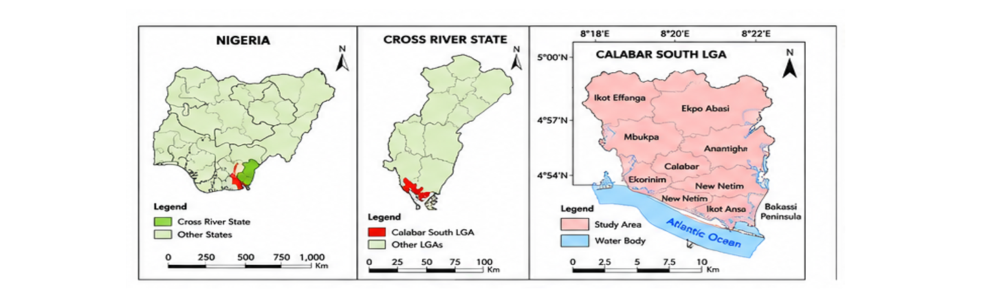
Flooding remains a persistent environmental hazard in coastal urban areas of southern Nigeria, particularly in Calabar South Local Government Area, where low elevation, intense rainfall, and rapid urbanization exacerbate flood impacts. This study assesses flood causative factors and delineates flood hazard and risk zones using an integrated GIS-based Multi-Criteria Analysis (MCA) framework. Five flood conditioning factors; elevation, slope, flow accumulation, rainfall intensity, and land use/land cover, were derived from SRTM Digital Elevation Model, Landsat imagery, and meteorological datasets. Factor weights were objectively determined using the Analytic Hierarchy Process (AHP), and spatial integration was performed through a weighted linear combination approach in ArcGIS. Flood risk assessment was conducted by integrating flood hazard with population density and land use exposure. Results indicate that approximately 58.6% of Calabar South falls within high to very high flood hazard zones, largely concentrated in low-lying southern areas. Flood risk analysis reveals that 35.9% of the study area is exposed to high to very high flood risk, driven by the coincidence of intense hazard conditions and dense urban development. Elevation and slope emerged as the dominant flood causative factors, while urban land use significantly amplifies flood risk. The generated flood hazard and risk maps provide reliable spatial decision-support tools for flood mitigation planning, land-use regulation, and disaster risk management in coastal urban environments.
References
Adeboboye, A. J., Nwali, H. I. and Atoki, L. O. (2024). Flood vulnerability mapping using remote sensing and GIS techniques in some selected LGA of Anambra State. International Journal of Multidisciplinary Research and Growth Evaluation. Department of Surveying and Geoinformatics, Nnamdi Azikiwe University Awka, Anambra State, Nigeria. Volume: 05, Issue: 03.
Adger, W. N., Brown, I., Surminski, S., (2018). ‘Advances in risk assessment for climate change adaptation policy’, Philosophical Transactions of the Royal Society A, Vol. 376, 20180106.
Aguirre-Ayerbe, I., Martínez Sánchez, J., Aniel-Quiroga, Í., González-Riancho, P., Merino, M., Al-Yahyai, S., González, M., Medina, R., (2018). ‘From tsunami risk assessment to disaster risk reduction – the case of Oman’, Natural Hazards and Earth System Sciences, Vol. 18, pp. 2241–2260.
Ali, K., Bajracharya, R. M. and Koirala, H. L. (2016). A Review of Flood Risk Assessment. International Journal of Environment, Agriculture and Biotechnology (IJEAB). (1)4, http://dx.doi.org/10.22161/ijeab/1.4.62
Batista e Silva, F., Marín Herrera, M. A., Rosina, K., Barranco, R. R., Freire, S., Schiavina, M., (2018). ‘Analysing spatiotemporal patterns of tourism in Europe at high-resolution with conventional and big data sources’, Tourism Management, Vol. 68, pp. 101–114.
Behzad, S.; Mohammad, R.; Asgharipour, and Bakhtiar, F. (2016). Improving farming practices using multi-criteria decision analysis in geographic information system for Damask Rose cultivating. Global Journal of Environmental Science and Management 2(4):327-338. DOI: 10.22034/gjesm.2016.02.04.002
Birkmann, J., Cutter, S. L., Rothman, D. S., Welle, T., Garschagen, M., van Ruijven, B., O’Neill, B., Preston, B. L., Kienberger, S., Cardona, O. D., Siagian, T., Hidayati, D., Setiadi, N., Binder, C. R., Huges, B., Pulwarty, R., (2015). ‘Scenarios for vulnerability: opportunities and constraints in the context of climate change and disaster risk’, Climatic Change, Vol. 133, pp. 53–68.
Brown, K., DiMauro, M., Johns, D., Holmes, G., Thompson, D., Russell, A., Style, D., (2018). ‘Turning risk assessment and adaptation policy priorities into meaningful interventions and governance processes’, Philosophical Transactions of the Royal Society A, Vol. 376, 20170303.
Buta, C., Mihai, G. and Stănescu, M. (2020). Flood Risk Assessment Based on Flood Hazard and Vulnerability Indexes. Ovidius University Annals Series: Civil Engineering, DOI: 10.2478/ouacsce-2020-0014.
Sherbinin, A., Bukvic, A., Rohat, G., Gall, M., McCusker, B., Preston, B., Apotsos, A., Fish, C., Kienberger, S., Muhonda, P., Wilhelmi, O., Macharia, D., Shubert, W., Sliuzas, R., Tomaszewski, B., Zhang, S., (2019). ‘Climate vulnerability mapping: A systematic review and future prospects’, Wiley Interdisciplinary Reviews: Climate Change, Vol. 10, No 5, pp. 1–23.
Donovan, A., (2019). ‘Critical volcanology? Thinking holistically about risk and uncertainty’, Bulletin of Volcanology, Vol. 81, No 20, pp. 1–6.
Efiong, J., Anara, D. I. and Odey, D. (2025). Effect of Demographic and Socio-Economic Factors on Community Resilience to Flood Hazard in Calabar South Local Government Area of Cross River State, Nigeria. World Environment Journal. Vol 5 No 1
Feizizadeh, B., Kienberger, S., (2017). ‘Spatially explicit sensitivity and uncertainty analysis for multicriteria-based vulnerability assessment’, Journal of Environmental Planning and Management, Vol. 60, No 11, pp. 2013–2035.
Ford, J.D., Pearce, T., McDowell, G., Berrang-Ford, L., Sayles, J. S., Belfer, E., (2018). ‘Vulnerability and its discontents: The past, present, and future of climate change vulnerability research’, Climatic Change, Vol. 151, pp. 189–203.
Hagenlocher, M., Meza, I., Anderson, C., Min, A., Renaud, F. G., Walz, Y., Siebert, S., Sebesvari, Z., (2019). ‘Drought vulnerability and risk assessments: State of the art, persistent gaps, and research agenda’, Environmental Research Letters, Vol. 14, No 8, 083002.
IASC and European Commission, (2019). INFORM Report 2019: Shared evidence for managing crises and disasters, https://reliefweb.int/ report/world/inform-report-2019-shared-evidence-managing-crises-and-disasters.
IPCC (Intergovernmental Panel on Climate Change), (2012). Managing the risks of extreme events and disasters to advance climate change adaptation: A special report of Working Groups I and II of the Intergovernmental Panel on Climate Change, eds.
Ismail-Zadeh, A., Cutter, S. L., Takeuchi, K., Paton, D., (2017). ‘Forging a paradigm shift in disaster science’, Natural Hazards, Vol. 86, pp. 969–988.
Jurgilevich, A., Räsänen, A., Groundstroem, F., Juhola, S., (2017). ‘A systematic review of dynamics in climate risk and vulnerability assessments’, Environmental Research Letters, Vol. 12, 013002.
Lauta, K. C., Albris, K., Zuccaro, G., Grandjean, G. (2018). ESPREssO Enhancing Risk Management Capabilities Guidelines, www.espressoproject.eu.
Maranzoni, A., D'Oria, M. and Rizzo, C. (2023). Quantitative flood hazard assessment methods. A Review. Journal of Flood Risk Management. 16, https://doi.org/10.1111/jfr3.12855
Metin, A. D., Dung, N. V., Schröter, K., Guse, B., Apel, H., Kreibich, H., Vorogushyn, S., Merz, B., (2018). ‘How do changes along the risk chain affect flood risk’, Natural Hazards and Earth System Sciences, Vol. 18, pp. 3089–3108.
Ozegin, K.O. and Ilugbo, S.O. (2025). Evaluation of potentially susceptible flooding areas leveraging geospatial technology with multicriteria decision analysis in Edo State, Nigeria. Natural Hazards Research, Volume 5, Issue 1, pp. 109-133
Peduzzi, P., (2019). ‘The disaster risk, global change, and sustainability nexus’, Sustainability, Vol. 11, p. 957.
Pescaroli, G., Alexander, D., (2018). ‘Understanding compound, interconnected, interacting, and cascading risks: A holistic framework’, Risk Analysis, Vol. 38, No 11, pp. 2245–2257.
Renner, K., Schneiderbauer, S., Pruß, F., Kofler, C., Martin, D., Cockings, S., (2017) ‘Spatio-temporal population modelling as improved exposure information for risk assessments tested in the Autonomous Province of Bolzano’, International Journal of Disaster Risk Reduction, Vol. 27, pp. 470–479.
Rohat, G., Flacke, J., Dao, H., van Maarseveen, M., (2018) ‘Co-use of existing scenario sets to extend and quantify the shared socioeconomic pathways’, Climatic Change, Vol. 151, pp. 619–636.
Rohat, G., Flacke, J., Dosio, A., Pedde, S., Dao, H., van Maarseveen, M., (2019) ‘Influence of changes in socioeconomic and climatic conditions on future heat-related health challenges in Europe’, Global and Planetary Change, Vol. 172, pp. 45–59.
Saaty, T.L. and Vargas, L.G. (2012). The seven pillars of the analytic hierarchy process Models, methods, concepts and applications of the analytic hierarchy process, Springer, Boston pp. 23-40
Saaty, T.L. (1990). An exposition of the AHP in reply to the paper “remarks on the analytic hierarchy process Manag. Sci., 36 (3) pp. 259-268
Schneiderbauer, S., Calliari, E., Eidsvig, U., Hagenlocher, M., (2017). ‘The most recent view of vulnerability’, in: Poljanšek, K., Marin Ferrer, M., De Groeve, T., Clark, I. (eds.), Science for Disaster Risk Management 2017: Knowing better and losing less, Publications Office of the European Union, Luxembourg, pp. 68–82.
Simmons, D. C., Dauwe, R., Gyenes, Z., King, A. G., Riedstra, D., Schneiderbauer, S., (2017). ‘Qualitative and quantitative approaches to risk assessment’, in: Poljanšek, K., Marin Ferrer, M., De Groeve, T., Clark, I. (eds.), Science for Disaster Risk Management 2017: Knowing better and losing less, Publications Office of the European Union, Luxembourg, pp. 44–58.
Sword-Daniels, V., Eriksen, C., Hudson-Doyle, E. E., Alaniz, R., Adler, C., Schenk, T., Vallance, S., (2018) ‘Embodied uncertainty: Living with complexity and natural hazards’, Journal of Risk Research, Vol. 21, No 3, pp. 290–307.
Tang, Y., Jing, J., Zhang, Z., Yang, Y. A., (2018) ‘Quantitative risk analysis method for the high hazard mechanical system in petroleum and petrochemical industry’, Energies, Vol. 11, pp. 1–18.
Tilloy, A., Malamud, B. D., Winter, H., July-Laugel, A., (2019) ‘A review of quantification methodologies for multi-hazard interrelationships’, Earth-Science Reviews, Vol. 196, 102881.
UNDRR, (2019). ‘Global Assessment Report on Disaster Risk Reduction 2019’, https://gar.unisdr.org/.
Vojtek, M. and Vojtekova, J. (2016). Flood Hazard and Flood Risk Assessment at the Local Spatial Scale: A Case Study. Geomatics, Natural Hazards and Risk, Vol. 7, No. 6, pp1973_1992, http://dx.doi.org/10.1080/19475705.2016.1166874
WEF (World Economic Forum), (2020) The Global Risks Report 2020: 15th edition, http://www3.weforum.org/docs.
Wenk, M., Neuhold, C., Fuchs, S., (2018). ‘Zielgruppenspezifische Darstellung von Hochwassergefahren und -risiko’, Österreichische Wasser-und Abfallwirtschaft, Vol. 70, No 5–6, pp. 328–340.
Zebisch, M., Schneiderbauer, S., Renner, K., Below, T., Brossmann, M., Ederer, W., Schwan, S., (2018). Risk Supplement to the Vulnerability Sourcebook.
Zscheischler, J., Westra, S., van den Hurk, B. J. J. M., Seneviratne, S. I., Ward, P. J., Pitman, A., AghaKouchak, A., Bresch, D. N., Leonard, M., Wahl, T., Zhang, X., (2018). ‘Future climate risk from compound events’, Nature Climate Change, Vol. 8, pp. 469–477.
Downloads
Published
Issue
Section
Categories
License
Copyright (c) 2026 Lucas Atoki, Sikiru Temitope Ibraheem

This work is licensed under a Creative Commons Attribution 4.0 International License.