
RETRIEVAL OF LAND SURFACE TEMPERATURE FROM EARTH OBSERVATION SATELLITES FOR GAS FLARING SITES IN THE NIGER DELTA, NIGERIA
DOI:
https://doi.org/10.33003/fjs-2026-1003-4772Keywords:
Thermal Remote Sensing, Earth Observation Satellites (EOS), Mapping, Gas Flaring, Land Surface Temperature (LST), EmissivityAbstract
Land Surface Temperature (LST) at gas flaring sites plays an essential role in various aspects such as monitoring vegetation and its growth; agricultural activities and productivity of several plant species; climate change and disaster monitoring. In the Niger Delta, limited researches have been undertaken on the LST measurement at flaring sites using Earth Observation Satellites (EOS) data. This research investigates the recording of LST by EOS for four gas flaring sites in Rivers State, Nigeria. Eleven Landsat 5 Thematic Mapper (TM) and Twenty Six Landsat 7 Enhanced Thematic Mapper Plus (ETM) from October 10, 1984 to March 08, 2013 with 5% cloud contamination were considered. Dark Object Subtraction (DOS) method and Atmospheric Correction Parameter (ATMCORR) Calculator were used to obtain the atmospheric correction (AC) effects parameters for the multispectral and the thermal bands respectively. The emissivity for each site is estimated by using standard values for determined land surface cover from the Look Up Table (LUT). The correction obtained from DOS method was applied to the computed reflectance to get the atmospherically corrected reflectance that was used for the classification of land cover. The thermal AC parameters obtained were applied to the calibrated at-sensor radiance band 6 (high gain) data to compute the surface-leaving radiance with the emissivity values obtained for each site. The Planck equation was inverted using the calibration constants to derive LST.
References
Abubakar, M. L., Thomas, D., Ahmed, M. S., & Abdussalam, A. F. (2024). Assessment of the relationship between land surface temperature and vegetation using MODIS NDVI and LST time series data in Kaduna metropolis, Nigeria. FUDMA Journal of Science, 8(2): 137-48
Aliabad, F. A., Zare, M., & Malamiri, H. G. (2021).Comparison of the accuracy of daytime land surface temperature retrieval methods using Landsat 8 images in arid regions. Infrared Phys. Technol., 115: 103692
Alvarez, J. (2009). Land cover verification along Freeway Corridors,
Natomas Basin Area, California, USA. Retrieved 26 April 2025 from
http://www.academic.emporia.edu/aberjame/student/alvarez4/natchange.htm
Anand, V., Kaur, S., Rajput, V. D., Minkinal, T., Mandzhieval, S., Kumar, S., Sharma, A., & Kumar, S. (2025). Analyzing the spatial relationship between land surface temperature and normalized difference vegetation index using remote sensing and GIS. Discov.Geosci.3, 65, https://doi.org/10.1007/s44288-025-00167-w
Anejionu, O. C. D., Blackburn, G. A., & Whyatt, J. D. (2014). Satellite survey of gas flares: Development and application of a Landsat based technique in the Niger Delta. International Journal of Remote Sensing, 35: 1900-1925.
Anejionu, O. C. D., Blackburn, G. A., & Whyatt, J. D. (2015). Detecting gas flares and
estimating flaring volumes at individual flow stations using MODIS data. Remote Sensing of
Environment, 158: 81-94.
Ayanlade, Y., & Howard, M. T. (2019). Land surface temperature and heat fluxes over three cities in Niger Delta. Journal of African Earth Sciences, 151: 54-66.
Barsi, J. A., Schott, J. R., Palluconi, F. D., & Hook, S. J. (2005). Validation of a
Web-Based Atmospheric Correction Tool for Single Thermal Band Instruments. Earth
Observing Systems X, Proceedings of SPIE Bellingham, WA, 2005.
Caseiro, A., Gehrke, B., Rücker, G., Leimbach, D., & Kaiser, J. W. (2019). Gas flaring activity and black carbon emissions in 2017 derived from Sentinel-3A SLSTR. Earth System Science Data: 1-35.
Chapin, F., Sturm, M., Serreze, M., McFadden, J., Key, J., Lloyd, A., McGuire, A., Rupp, T., Lynch, A., & Schimel, J. (2005). Role of Land-Surface Changes in Arctic Summer Warming. Science, 310: 657-660.
Chander, G., & Markham, K. (2003). Revised Landsat-5 TM Radiometric Calibration
Procedures and Post calibration Dynamic Ranges. IEEE Transactions on
Geoscience and Remote Sensing, 41(11): 2674-2677.
Chen, F., Zhao, X., & Ye, H. (2012). Making use of the Landsat 7 SLC-off ETM+
image through different recovering approaches. Postgraduate Conference on
Infrastructure and Environment (3rd IPCIE), vol. 2, pp. 557-563. Retrieved 26
February 2025 from http://dx.doi.org/10.5772/48535
Chowdhury, S., Shipman, T., Chao, D., Elvidge, C. D., Zhizhin, M., & Hsu, F. C.
(2014). Daytime gas flare detection using Landsat-8 multispectral data. In
Proceedings of the IEEE International Geosciences of Remote Sensing Symposium,
Quebec City, QC, Canada, 13-18 July pp. 258-261.
Coll, C., Galve, J. M., Sanchez, J. M, & Caselles, V. (2010). Validation of Landsat - 7
ETM+ thermal-band calibration and atmospheric correction with ground-based
measurement. IEEE Transaction on Geoscience and Remote Sensing 48(1):
547-555.
de Almeida, C. R., Teodoro, A. C., & Goncalves, A. (2021). Study of the urban heat island (UHI) using remote sensing data/techniques: a systematic review. Environments, 8(10): 105.
Dung, E. J., Bombom, L. S., & Agusomu, T. D. (2008).The effects of gas flaring on crops in
the Niger Delta, Nigeria. GeoJournal, 73: 297-305.
Elvidge, C. D., Ziskin, D., Baugh, K. E., Tuttle, B. T., Ghosh, T., Pack, D. W., Erwin,
E. H., & Zhizhin, M. A. (2009). A Fifteen Year Record of Global Natural Gas Flaring
Derived from Satellite Data. Energies, 2: 595-622.
ESA.(2026). European Space Agency. “AATSR Product Handbook, Issue 2.2, Italy.
Retrieved 14 January 2026 from
http: www.earth.esa.int/pub/ESA_DOC/.../AATSR/aatsr.ProductHandbook.2_2.pdf
Faruolo, M., Lacava, T., Pergola, N., & Tramutoli, V. (2018).On the Potential of the RST-FLARE Algorithm for Gas Flaring Characterization from Space. Sensors, 18: 2466.
Fisher, D., & Wooster, M. (2018).Shortwave IR Adaptation of the Mid-Infrared Radiance Method of Fire Radiative Power (FRP) Retrieval for Assessing Industrial Gas Flaring Output. International Journal of Remote Sensing, 10: 305.
Govil, H., Guha, S., Diwan, P., Gill, N., & Dey, A. (2020). Analyzing linear relationships of LST with NDVI and MNDISI using various resolution levels of Landsat 8 OLI and TIRS data. In: Sharma N, Chakrabarti A, Balas VE, editors. Data management, analytics and innovation: proceedings of ICDMAI 2019, vol. 1. Singapore: Springer, 171-84.
Giannini, M. B., Belfiore, O. R., Parente, C., & Santamaria, R. (2015). Land Surface Temperature from Landsat 5 TM images: comparison of different methods using airborne thermal data. Journal of Engineering Science and Technology Review, 8 (3): 83-90.
Gillespie, A., Rokugawa, S., Matsunaga, T., Cothern, J. S., Hook, S., & Kahle, A. B. (1998). A temperature and emissivity separation algorithm for Advanced Spaceborne Thermal Emission and Reflection Radiometer (ASTER) images. IEEE Transactions on Geoscience and Remote Sensing, 36 (4): 1113-1126.
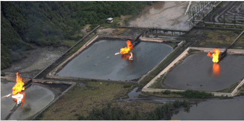
Google Earth. (2026). Image showing Eleme Petroleum Refinery II Company, Bonny
LNG, Obigbo Flow Station and Umudioga Flow Station.
Guha S. (2021). A long-term monthly assessment of land surface temperature and normalized difference vegetation index using Landsat data.urbe. Revista Brasileira de Gestão Urbana, v.13, e20200345.https://doi.org/10.1590/2175-3369.013.e20200345
Harris, A. R., & Mason, I. M. (1992).An extension to the split-window technique giving improved atmospheric correction and total water vapour. International Journal of Remote Sensing, 13: 881-892.
Hipps, L. E. (1989). The infrared emissivities of soil and Artemisia tridentate and
subsequent temperature corrections in a shrub-steppe ecosystem. Remote Sensing
of Environment, 27: 337-342.
Htway, N. N., & Thin, L. M. (2024). Prediction of land surface temperature in dry zone, Myanmar using MODIS derived NDVI and LST. In: Htway NN, editor. IEEE conference on computer applications (ICCA). Yangon: IEEE; p. 1-6
Humes, K. S., Kustas, W. P., Moran, M. S., Nichols, W. D., & Weltz, M. A. (1994).
Variability of emissivity and surface temperature over a sparsely vegetated surface.
Water Resources Research, 30(5): 1299-1310.
Irfeey, A. M. M., Chau, H. W., Sumaiya, M. M. F., Wai, C. Y., Muttil, N., & Jamei, E. (2023). Sustainable mitigation strategies for urban heat island effects in urban areas. Sustainability, 15(14): 10767
Jiang, Y., & Lin, W. P. (2021). A comparative analysis of retrieval algorithms of land surface temperature from landsat-8 data: a case study of Shanghai, China. International Journal of Environmental Research and Public Health, 18(11): 5659.
Jiménez-Muñoz, J. C., Sobrino, J. A., El-Kharraz, J., Gómez, M., Romaguera, M &Sòria, G.
(2003). Synergistic use of DAIS bands to retrieve land surface emissivity and temperature.
IGARSS 2003: IEEE International Geoscience and Remote Sensing Symposium, Vols. I-VII,
Proceedings: 1062-1064.
Jin, M., & Liang, S. (2006). An Improved Land Surface Emissivity Parameter for Land
Surface Models Using Global Remote Sensing Observations. Journal of Climate,
19: 2867-2881.
Kalnay, E., &Cai, M. (2003). Impact of Urbanization and Land-use Change on Climate. Nature, 423: 528-531.
Karnieli, A., Agam, N., Pinker, R. T., Anderson, M., Imhoff, M.L., Gutman, G. G., Panov, N., & Goldberg, A. (2010). Use of NDVI and Land Surface Temperature for Drought Assessment: Merits and Limitations. Journal of Climatology, 23: 618-633.
Kaufman, Y. J., Karnieli, A., & Tanre, D. (2000). Detection of dust over deserts using
satellite data in the solar wavelengths. IEEE Transactions on Geoscience and
Remote Sensing 38: 525-531.
Kemarau, R. A., & Eboy, O. V. (2021).Application of Thermal Remote Sensing to Study of Land Surface Temperature as Indicator Land Cover Change in Wetland and Vegetation. Arabian Journal of Business and Management Review (Kuwait Chapter), 10(1): 42-48, https://j.arabianjbmr.com/index.php/kcajbmr/article/view/1088
Labed, J., & Stoll, M. P. (1991). Spatial variability of land surface emissivity in the
thermal infrared band: Spectral signature and effective surface temperature. Remote
Sensing of Environment, 38: 1-7.
Li, Z. L., Wu, H., Duan, S.B., Zhao, W., Ren, H., Liu, X, et al. (2023). Satellite remote sensing of global land surface temperature: definition, methods, products, and applications. Rev. Geophys., https://doi.org/10.1029/2022RG000777
Liang, S., Fallah-Adl, H., Kalluri, S., JaJa, J., Kaufman, Y., & Townshend, J. (1997).
Development of an operational atmospheric correction algorithm for TM imagery.
Journal of Geophysical Research, 102: 17173-17186.
Liang, S., Fang, H., & Chen, M. (2001). Atmospheric Correction of Landsat ETM+
Land Surface Imagery - Part I: Methods. IEEE Transactions on Geoscience and
Remote Sensing, 39(11): 2490-2498.
Liu, Y., Chao, S., Yang, Y., Zhou, M., Zhan, W., & Cheng, W. (2016). Automatic extraction of
offshore platforms using time-series Landsat-8 Operational Land Imager data. Remote
Sensing of Environment, 175: 73-91.
Lu, W., Liu, Y., Wang, J., Xu, W., Wu, W., Liu, Y., Zhao, B., Li, H., &Li, P. (2020). Global
proliferation of offshore gas flaring areas. Journal of Maps, 16(2): 396-404, DOI:
10.1080/17445647.2020.1762773
Mao, K., Qin, Z., Shi, J., & Gong, P. (2005).A practical split-window algorithm for retrieving land surface temperature from MODIS data. International Journal of Remote Sensing, 26(15): 3181-3204.
Masuda, K., Takashima, T., &Takayama, Y. (1988). Emissivity of Pure and Sea
Waters for the Model Sea Surface in the Infrared Window Regions. Remote Sensing
of Environment, 24: 313-329.
Morakinyo, B. O. (2025a).Environmental Impact Assessment on Vegetation Cover at a Selected Gas Flaring Site in the Niger Delta. Nile Journal of Engineering and Applied Science (NJEAS), 2(2), 233-240, DOI: https://doi.org/10.5455/NJEAS.222273
Morakinyo, B. O. (2025b). Remote Sensing of Spatial and Temporal Mapping of Flare Impacts in the Niger Delta, Nigeria. Journal of International Environmental Application and Science (JIEAS), 20, 98-115.
Morakinyo, B. O. (2025c).Geospatial Information for Land Use Planning and Sustainable Management. FUDMA Journal of Sciences (FJS).Faculty of Science, Federal University, Dutsin-Ma, Katsina State, Nigeria, 9(2), 105-118, DOI: https://doi.org/10.33003/fjs-2025-0902-3146
Morakinyo, B. O., Lavender, S., & Abbott, V. (2025).Detection of Potentially Gas Flaring-related Pollution on Vegetation Cover and Its Health Using Remotely Sensed Data in the Niger Delta. Nile Journal of Engineering and Applied Science (NJEAS). 3(1), 49-58, DOI: https://doi.org/10.5455/NJEAS.287918
Morakinyo, B. O. (2024).Time Series Analysis of Earth Observation Satellites Data for Evaluating Changes in Vegetation Cover and Health at Flaring Sites. Academic Platform Journal of Natural Hazards and Disaster Management (APJHAD). Faculty of Engineering, Sakarya University, Turkey, 5(2), 76-100, DOI: 10.52114/apjhad.1557231
Morakinyo, B. O. (2023). Detection of Impacts of Gas Flaring in the Environment: Application of Landsat Earth Observation Data. BAZE University Journal of Entrepreneurship and Interdisciplinary Studies (BUJEIS): 2(1), 2023: ISSN 2971-7124
Morakinyo, B. O., Lavender, S., & Abbott, V. (2022a). Investigation of Potential Prevailing Wind Impact on Land Surface Temperature at Gas Flaring Sites in the Niger Delta, Nigeria. International Journal of Environment and Geoinformatics (IJEGEO), 9(1): 179-190.
Morakinyo, B. O., Lavender, S., & Abbott, V. (2022b).Evaluation of Factors Influencing Changes in Land Surface Temperature at Gas Flaring Sites in the Niger Delta, Nigeria. BAZE University Journal of Entrepreneurship and Interdisciplinary Studies (BUJEIS): 1(2), 2022: ISSN 2971-7124
Morakinyo, B. O., Lavender, S., & Abbott, V. (2021). The Methodology and Results from Ground Validation of Satellite Observations at Gas Flaring Sites in Nigeria. International Journal of Environment and Geoinformatics (IJEGEO), 8(3): 290-300. doi. 10.30897/ijegeo.749664
Morakinyo, B. O., Lavender, S., Schwarz, J., & Abbott, V. (2019).Mapping of land
cover and estimation of their emissivity values for gas flaring sites in the Niger Delta.
British Journal of Environmental Sciences, 7(2): 31-58.
Musa, D. G., Oruonye, E. D., Anger, R. T., Ojeh, V. N.,& Delphine, D. (2024) Effect of Gas
Flaring on Human Well-Being and Environ. in Obodo-Ugwa, Ndokwa West, Local
Government Area, Delta State, Nigeria. Journal of Engineering & Environmental
Science, 2(1): 000108.https://medwinpublishers.com/JEESc/effect-of-gas-flaring-on-human-well-being-and-environment-in-obodo-ugwa,-ndokwa-west,-local-government-area,-delta-state,-nigeria.pdf
NASA.(2002). National Aeronautics and Space Administration. Landsat 7 ETM+
Science Data Users Handbook. Retrieved 23rd August 2025 from
http://www.landsathandbook.gsfc.nasa.gov/data_prod/prog_sect11_3.html
NASA.(2026). National Aeronautics and Space Administration. Landsat Science.
Retrieved 1st January 2026 from http://landsat.gsfc.nasa.gov/?p=3180
NOAA.(2026). National Oceanic and Atmospheric Administration. Advanced Very
High Resolution Radiometer (AVHRR): Overview. Retrieved 15th January 2026 from
https://www.ngdc.noaa.gov/ecosys/cdroms/AVHRR97_d1/avhrr.htm
Nwaerema, P., Ologunorisa, T. E., Nwagbara, M. O., & Ojeh, V. N. (2019). Geo-Spatial Dynamics of Land Surface Temperature of Port Harcourt Metropolis and Environs: Implication for Heat Disaster Management. Earth Sciences.8(3): 169-177.
Otukei, J. R., & Blaschke, T. (2012). You Know The Temperature at the Weather
Station But Do You Know It Anywhere Else? Assessing Land Surface Temperature
Using Landsat ETM+ Data. In Proceedings of The first Conference on Advances in
Geomatics Research. Retrieved 10th January 2026 from
http://www.cedat.mak.ac.ug/wp-content/themes/CEDATTheme/Publications/You%20
Know%20The%20Temperature%20at%20the%20Weather%20Station%20But%20D
o%20You%20Know%20It%20Anywhere%20 Else_Assessing%20Land%20S.pdf
Pande, C. B., Egbueri, J. C., Costache, R., Sidek, L. M., Wang, Q., & Alshehri, F, et al. (2024). Predictive modeling of land surface temperature (LST) based on Landsat-8 satellite data and machine learning models for sustainable development. Journal of Clean Production, 444: 141035.
Polat, A. B., Akcay, O., &Kontas, F. (2024) Drought monitoring in Burdur Lake, Turkey
using multi-sensor remote sensing data sets. Advance Geodesy &Geoinformatics (formerly
Geodesy and Cartography), 73(1), article no. e47, DOI:10.24425/agg.2023.146159
PTT.(2008). Flaring and venting philosophy. Retrieved 12th February 2025 from
http://www. Scribd.com/doc/108536828/Flaring-and-Venting-Philosophy
Qin, Z., Olmo, G. D., & Karnieli, A. (2011). Derivation of split window algorithm and its sensitivity analysis for retrieving land surface temperature from NOAA-advanced very high resolution radiometer data. Geophysical Research, 22655-22 670.
Rozenstein, O., Qin, Z., Derimian, Y and Karnieli, A. (2014). Derivation of Land
Surface Temperature for Landsat-8 TIRS Using a Split Window Algorithm. Sensors,
4: 5768-5780; doi: 10.3390/s140405768
Sáez, A. (2010). Industrial application of natural gas. Retrieved 1st March 2025 from
http://www.intechopen.com/books/natural-gas/industrial-applications-of-natural-gas
Şatır, O., & Berberoğlu, S. (2012). Land Use/Cover Classification Techniques Using
Optical Remotely Sensed Data in Landscape Planning, Landscape Planning, Dr.
Murat Ozyavuz (Ed.), ISBN: 978-953-51-0654-8, InTech. Retrieved 15th September
2025 from http://www.intechopen.com/books/landscapeplanning/land-use-cover-
classificationtechniques-using-optical-remotelysensed-data-in-landscape-plannin
Sharma, K., Tiwari, R., Wadhwani, A. K., & Chaturvedi, S. (2024). Spatiotemporal analysis of land surface temperature trends in Nashik, India: a 30-year study from 1992 to 2022. Earth Science Information, https://doi.org/10.1007/s12145-024-01260-3.
Shore, D. (1996).Making the flare safe. Journal of Loss Prevention in the Process
Industries, 9(6).
Sobrino, J. A., Li, Z. –L., & Stoll, M. P. (1993). Impact of the atmospheric transmittance and total water vapour content in the algorithms for estimating satellite sea temperature. IEEE Transactions on Geoscience and Remote Sensing, 31: 946-952.
Sobrino, J.A., Jiménez-Muñoz, J. C., & Paolini, L. (2004). Land surface temperature
retrieval from LANDSAT TM 5. Remote Sensing of Environment, 90(4): 434-440.
Stathopoulou, M., & Cartalis, C. (2007). Daytime urban heat island from Landsat
ETM+ and Corine land cover data: An application to major cities in Greece.
Solar Energy, 81: 358-368.
Umbugala, U. D., & Morakinyo, B. O. (2023).Detection of Oil and Gas Platforms in the Niger Delta, Nigeria: Role of Digital Technology in Facilities Management. BAZE University Journal of Entrepreneurship and Interdisciplinary Studies, 2(2), 2(2), 11-22.
USGS.(2026). United States Geological Survey. U. S. Department of the Interior. Retrieved 11th January 2026 from http://eros.usgs.gov/#/Find_Data/Products_and_Data_Available/ETM
van de Griend, A. A., Owe, M., Groen, M., & Stoll, M. P. (1991). Measurement and
spatial variation of thermal infrared surface emissivity in a savanna environment.
Water Resources Research, 27: 371-379.
VOA. (2026). Satellite Tracker Throws Light on Gas Flaring in Nigeria. Retrieved 16th
January 2026 from https://www.voanews.com/a/satellite-tracker-throws-light-on-gas-flaring-in-nigeria/2536982.html
Wan, Z. (2002). Validation of the land-surface temperature products retrieved from Terra Moderate Resolution Imaging Spectroradiometer data. Remote Sensing of Environment, 83: 163-180.
Wan, Z., Zhang, Y., Zhang, Q., & Li, Z. (2004a). Quality assessment and validation of the MODIS global land surface temperature. International Journal of Remote Sensing, 25: 261-274.
Wan, Z., Wang, P., & Li, X. (2004b). Using MODIS Land Surface Temperature and Normalized Difference Vegetation Index Products for Monitoring Drought in the Southern Great Plains, USA. International Journal of Remote Sensing, 25: 61-72.
Wei, W., Zhang, H., Zhou, J., Zhou, L., Xie, B., &Li, C, (2021). Drought monitoring in arid
and semi-arid region based on multi-satellite datasets in Northwest China. Environmental
Science& Pollution Research, 28: 51556-51574.https://doi.org/10.1007/s11356-021-14122-y
Zhang, X., Zhou, J., Liang, S., & Wang, D. A. (2021). Practical reanalysis data and thermal infrared remote sensing data merging (RTM) method for reconstruction of a 1-km all-weather land surface temperature. Remote Sensing of Environment, 260: 112437
Downloads
Published
Issue
Section
Categories
License
Copyright (c) 2026 Barnabas O. Morakinyo

This work is licensed under a Creative Commons Attribution 4.0 International License.

