
URBAN GROWTH AND THERMAL ENVIRONMENT DYNAMICS IN KADUNA, NIGERIA: LAND USE CHANGE, UHI, UTFVI, AND A NOVEL VEGETATION COOLING EFFICIENCY INDEX
DOI:
https://doi.org/10.33003/fjs-2026-1001-4116Keywords:
Urban growth, Land surface temperature, Urban heat island, UTFVI, VCEI, Kaduna metropolisAbstract
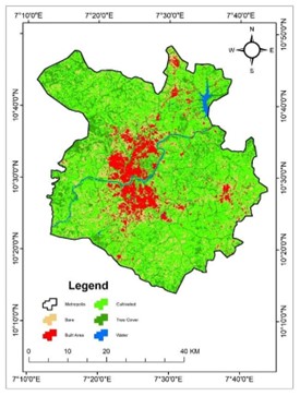
Rapid urbanization has accelerated land use/land cover (LULC) changes and accompanying thermal stress in cities across sub-Saharan Africa. This study investigated the relationships between urban growth and ecological thermal conditions in Kaduna Metropolis, Nigeria, between 2004 and 2024 via Landsat data and remote sensing indices. LULC was divided into five classes—bare terrain, built-up areas, cultivated lands, tree cover, and water bodies—through multiresolution segmentation and a decision tree algorithm. The land surface temperature (LST) was derived via thermal bands, whereas the urban heat island (UHI) intensity and the urban thermal field variance index (UTFVI) were employed to measure spatial changes in thermal stress. This study introduces the Vegetation Cooling Efficiency Index (VCEI) to evaluate the cooling impact of vegetation. The results demonstrate strong increases in built-up areas (+121.04 km²) and bare fields (+596.19 km²), mostly at the expense of cultivated lands (–525.54 km²) and tree cover (–191.91 km²). The mean LST rose from 32.2 °C in 2004 to 35.7 °C in 2024, with significant geographic differences in surface heating. UHI hotspots persisted in urban cores; however, the maximum intensity decreased significantly (from +5.27 °C to +3.72 °C), whereas the UTFVI suggested moderate and rather stable ecological thermal stress. The VCEI confirmed the continuous cooling effect of vegetation, while its efficacy diminished with vegetation removal. These findings reinforce the importance of unplanned urban growth in modifying thermal settings and highlight the necessity of green infrastructure and vegetation preservation in promoting ecological resilience and thermal comfort.
References
Abd-Elmabod, S. K., Jiménez-González, M. A., Jordán, A., Zhang, Z., Mohamed, E. S., Hammam, A. A., El Baroudy, A. A., Abdel-Fattah, M. K., Abdelfattah, M. A., & Jones, L. (2022). Past and future impacts of urbanisation on land surface temperature in Greater Cairo over a 45 year period. The Egyptian Journal of Remote Sensing and Space Science, 25(4), 961–974. https://doi.org/10.1016/j.ejrs.2022.10.001
Abdussalam, A. F. (2020). Climate Change and Health Vulnerability in Informal Urban Settlements of Kaduna Metropolis. Science World Journal, 15(3), 127–132. https://doi.org/10.47514/swj/15.03.2020.020
Abubakar, M. L. (2019). Analysis of Land Use Land Cover in Danja Local Government Area, Katsina - Nigeria, From 1986 To 2019. 60th Annual Conference of the Association of Nigerian Geographers (ANG). https://doi.org/10.13140/RG.2.2.12948.65920
Abubakar, M. L., & Abdussalam, A. F. (2024). Geospatial analysis of land use changes and wetland dynamics in Kaduna Metropolis, Kaduna, Nigeria. Science World Journal, 19(3), 687–696. https://doi.org/10.4314/swj.v19i3.15
Abubakar, M. L., Thomas, D., Ahmed, M. S., & Abdussalam, A. F. (2024). Assessment of the Relationship Between Land Surface Temperature and Vegetation Using MODIS LST and NDVI Timerseries Data in Kaduna Metropolis, Nigeria. FUDMA JOURNAL OF SCIENCES, 8(2), 137–148. https://doi.org/10.33003/fjs-2024-0802-2305
Adão, F., Fraga, H., Fonseca, A., Malheiro, A. C., & Santos, J. A. (2023). The Relationship between Land Surface Temperature and Air Temperature in the Douro Demarcated Region, Portugal. Remote Sensing 2023, Vol. 15, Page 5373, 15(22), 5373. https://doi.org/10.3390/RS15225373
Agarwal, C., & Sharma, A. (2011). Image understanding using decision tree based machine learning. 2011 International Conference on Information Technology and Multimedia: “Ubiquitous ICT for Sustainable and Green Living”, ICIM 2011. https://doi.org/10.1109/ICIMU.2011.6122757
Ahmed, M. S., Abubakar, M. L., Lawal, A. I., & Richifa, K. I. (2024). Influence of extreme temperature on adverse pregnancy outcomes in Kaduna State, Nigeria. Science World Journal, 19(2), 409–417. https://doi.org/10.4314/swj.v19i2.17
Ajibade, L. T., & Okwori, A. (2009). Developing an Information System for Rural Water Supply Scheme in Kaduna State. Journal of Environmental Science, 1(1), 1–8.
Akpu, B., Tanko, A., Jeb, D., & Dogo, B. (2017). Geospatial Analysis of Urban Expansion and Its Impact on Vegetation Cover in Kaduna Metropolis, Nigeria. Asian Journal of Environment & Ecology, 3(2), 1–11. https://doi.org/10.9734/ajee/2017/31149
Al Shawabkeh, R., AlHaddad, M., Al-Fugara, A., Al-Hawwari, L., Al-Hawwari, M. I., Omoush, A., & Arar, M. (2023). Modeling the impact of urban land cover features and changes on the land surface temperature (LST): The case of Jordan. Ain Shams Engineering Journal, June, 102359. https://doi.org/10.1016/j.asej.2023.102359
Alawamy, J. S., Balasundram, S. K., Mohd. Hanif, A. H., & Boon Sung, C. T. (2020). Detecting and Analyzing Land Use and Land Cover Changes in the Region of Al-Jabal Al-Akhdar, Libya Using Time-Series Landsat Data from 1985 to 2017. Sustainability, 12(11), 4490. https://doi.org/10.3390/su12114490
Amin, M., & Dadan-Garba, A. (2014). Urban Vegetation Study of Kaduna Metropolis using GIS and Remotely sensed Data. Journal of Natural Sciences Research, 4(4), 160–171.
Andronis, V., Karathanassi, V., Tsalapati, V., Kolokoussis, P., Miltiadou, M., & Danezis, C. (2022). Time Series Analysis of Landsat Data for Investigating the Relationship between Land Surface Temperature and Forest Changes in Paphos Forest, Cyprus. Remote Sensing, 14(1010). https://doi.org/10.3390/rs14041010
Arias, M., Notarnicola, C., Campo-Bescós, M. Á., Arregui, L. M., & Álvarez-Mozos, J. (2023). Evaluation of soil moisture estimation techniques based on Sentinel-1 observations over wheat fields. Agricultural Water Management, 287, 108422. https://doi.org/10.1016/J.AGWAT.2023.108422
Avdan, U., & Jovanovska, G. (2016). Algorithm for Automated Mapping of Land Surface Temperature Using LANDSAT 8 Satellite Data. Journal of Sensors, 2016, 1–8. https://doi.org/10.1155/2016/1480307
Baba, B. M., Abubakar, M. L., Raji, R. B., & Ibrahim, R. (2020). Spatial Distribution of Electric Transformers in Narayi Ward, Chikun Local Government Area of Kaduna State, Nigeria. Kaduna Journal of Geography, 2(2), 114–130. https://doi.org/10.5281/zenodo.14598765
Barsi, J. A., Lee, K., Kvaran, G., Markham, B. L., & Pedelty, J. A. (2014). The spectral response of the Landsat-8 operational land imager. Remote Sensing, 6(10), 10232–10251. https://doi.org/10.3390/rs61010232
Barsi, J. A., Schott, J., Hook, S., Raqueno, N., Markham, B., & Radocinski, R. (2014). Landsat-8 Thermal Infrared Sensor (TIRS) Vicarious Radiometric Calibration. Remote Sensing, 6(11), 11607–11626. https://doi.org/10.3390/rs61111607
Basu, A., & Das, S. (2021). Afforestation, revegetation, and regeneration: a case study on Purulia district, West Bengal (India) (pp. 497–524). https://doi.org/10.1016/B978-0-12-823895-0.00014-2
Becker, F. (1987). The impact of spectral emissivity on the measurement of land surface temperature from a satellite. International Journal of Remote Sensing, 8(10), 1509–1522. https://doi.org/10.1080/01431168708954793
Bennett, J. G., Rains, A. B., Gosden, P. N., Howard, W. J., Hutcheon, A. A., Kerr, W. B., Mansfield, J. E., Rackham, L. J., & Wood, A. W. (1979). Land Resources of central Nigeria; agricultural development possibilities. Volume 3A. The Jema’a Platform Executive Summary. In I. D. Hill (Ed.), Agricultural development possibilities: The Jema’a Platform (Vol. 3B). Land Resources Development Centre.
Bharath, H. A., Nimish, G., & Chandan, M. C. (2020). Exposition of spatial urban growth pattern using PSO-SLEUTH and identifying its effects on surface temperature. In Urban Ecology (pp. 49–68). Elsevier. https://doi.org/10.1016/B978-0-12-820730-7.00004-5
Cetin, M., Ozenen Kavlak, M., Senyel Kurkcuoglu, M. A., Bilge Ozturk, G., Cabuk, S. N., & Cabuk, A. (2024). Determination of land surface temperature and urban heat island effects with remote sensing capabilities: the case of Kayseri, Türkiye. Natural Hazards, 120(6), 5509–5536. https://doi.org/10.1007/S11069-024-06431-5/METRICS
Congalton, R. G. (1991). A review of assessing the accuracy of classifications of remotely sensed data. Remote Sensing of Environment, 37(1), 35–46. https://doi.org/10.1016/0034-4257(91)90048-B
Das, D. N., Chakraborti, S., Saha, G., Banerjee, A., & Singh, D. (2020). Analysing the dynamic relationship of land surface temperature and landuse pattern: A city level analysis of two climatic regions in India. City and Environment Interactions, 8, 100046. https://doi.org/10.1016/j.cacint.2020.100046
Faisal, A. Al, Kafy, A. A., Al Rakib, A., Akter, K. S., Jahir, D. M. A., Sikdar, M. S., Ashrafi, T. J., Mallik, S., & Rahman, M. M. (2021). Assessing and predicting land use/land cover, land surface temperature and urban thermal field variance index using Landsat imagery for Dhaka Metropolitan area. Environmental Challenges, 4. https://doi.org/10.1016/J.ENVC.2021.100192
GRID3 - Nigeria. (2024). Geo-Referenced Infrastructure and Demographic Data for Development. National Space Research and Development Agency. http://grid3.gov.ng/
Hidalgo-García, D., & Arco-Díaz, J. (2022). Modeling the Surface Urban Heat Island (SUHI) to study of its relationship with variations in the thermal field and with the indices of land use in the metropolitan area of Granada (Spain). Sustainable Cities and Society, 87(March). https://doi.org/10.1016/j.scs.2022.104166
Kaduna Bureau of Statistics. (2015). Population Projections for Kaduna State.
Kaduna State Government. (2021). El-Rufai launches Kaduna Urban Renewal Project.
Kim, S. W., & Brown, R. D. (2021). Urban heat island (UHI) intensity and magnitude estimations: A systematic literature review. Science of The Total Environment, 779, 146389. https://doi.org/10.1016/j.scitotenv.2021.146389
Kodors, S. (2019). Detection of Man-Made Constructions Using LiDAR Data and Decision Trees. Baltic Journal of Modern Computing, 7(2). https://doi.org/10.22364/bjmc.2019.7.2.05
Koko, A. F., Wu, Y., Abubakar, G. A., Alabsi, A. A. N., Hamed, R., & Bello, M. (2021). Thirty Years of Land Use/Land Cover Changes and Their Impact on Urban Climate: A Study of Kano Metropolis, Nigeria. Land, 10(11), 1106. https://doi.org/10.3390/LAND10111106
Koko, A. F., Yue, W., Abubakar, G. A., Alabsi, A. A. N., & Hamed, R. (2021). Spatiotemporal influence of land use/land cover change dynamics on surface urban heat island: A case study of abuja metropolis, nigeria. ISPRS International Journal of Geo-Information, 10(5). https://doi.org/10.3390/ijgi10050272
Kusumawardani, K. P., & Hidayati, I. N. (2022). Analysis of urban heat island and urban ecological quality based on remote sensing imagery transformation in semarang city. IOP Conference Series: Earth and Environmental Science, 1089(1). https://doi.org/10.1088/1755-1315/1089/1/012037
Laliberte, A. S., Fredrickson, E. L., & Rango, A. (2007). Combining decision trees with hierarchical object-oriented image analysis for mapping arid rangelands. Photogrammetric Engineering and Remote Sensing, 73(2), 197–207. https://doi.org/10.14358/PERS.73.2.197
Li, X., Zhou, Y., Yu, S., Jia, G., Li, H., & Li, W. (2019). Urban heat island impacts on building energy consumption: A review of approaches and findings. Energy, 174, 407–419. https://doi.org/10.1016/j.energy.2019.02.183
Litardo, J., Palme, M., Borbor-Cordova, M., Caiza, R., Macias, J., Hidalgo-Leon, R., & Soriano, G. (2020). Urban Heat Island intensity and buildings’ energy needs in Duran, Ecuador: Simulation studies and proposal of mitigation strategies. Sustainable Cities and Society, 62(July), 102387. https://doi.org/10.1016/j.scs.2020.102387
Mahato, S., Kundu, B., Makwana, N., & Joshi, P. K. (2023). Early summer temperature anomalies and potential impacts on achieving Sustainable Development Goals (SDGs) in National Capital Region (NCR) of India. Urban Climate, 52, 101705. https://doi.org/10.1016/j.uclim.2023.101705
Mhana, K. H., Norhisham, S. Bin, Katman, H. Y. B., & Yaseen, Z. M. (2023). Environmental impact assessment of transportation and land alteration using Earth observational datasets: Comparative study between cities in Asia and Europe. Heliyon, 9(9), e19413. https://doi.org/10.1016/j.heliyon.2023.e19413
Moisa, M. B., & Gemeda, D. O. (2022). Assessment of urban thermal field variance index and thermal comfort level of Addis Ababa metropolitan city, Ethiopia. Heliyon, 8(8). https://doi.org/10.1016/j.heliyon.2022.e10185
Mokarram, M., Taripanah, F., & Pham, T. M. (2023). Investigating the effect of surface urban heat island on the trend of temperature changes. Advances in Space Research, 72(8), 3150–3169. https://doi.org/10.1016/j.asr.2023.06.048
Muhammad, R. Z., & Abubakar, M. L. (2025). Assessing the influence of land surface temperature and sociodemographic factors on measles prevalence using AutoML and SHAP in Kaduna North, Nigeria. GeoJournal, 90(3), 103. https://doi.org/10.1007/s10708-025-11361-1
Musa, K., & Abubakar, M. L. (2024). Monitoring urban growth and landscape fragmentation in Kaduna, Nigeria, using remote sensing approach. Journal of Degraded and Mining Lands Management, 12(1), 6757–6769. https://doi.org/10.15243/jdmlm.2024.121.6757
Naserikia, M., Hart, M. A., Nazarian, N., Bechtel, B., Lipson, M., & Nice, K. A. (2023). Land surface and air temperature dynamics: The role of urban form and seasonality. Science of The Total Environment, 905, 167306. https://doi.org/10.1016/J.SCITOTENV.2023.167306
Norman, J. M., & Becker, F. (1995). Terminology in thermal infrared remote sensing of natural surfaces. Agricultural and Forest Meteorology, 77(3–4), 153–166. https://doi.org/10.1016/0168-1923(95)02259-Z
Patel, S., Indraganti, M., & Jawarneh, R. N. (2024). Urban planning impact on summer human thermal comfort in Doha, Qatar. Building and Environment, 254(February), 111374. https://doi.org/10.1016/j.buildenv.2024.111374
Peacock, R. (2014). Accuracy Assessment of Supervised and Unsupervised Classification Using Landsat Imagery of Little Rock, Arkansas. NORTHWEST MISSOURI STATE UNIVERISTY.
Peng, X., Wu, W., Zheng, Y., Sun, J., Hu, T., & Wang, P. (2020). Correlation analysis of land surface temperature and topographic elements in Hangzhou, China. Scientific Reports, 10(1), 1–16. https://doi.org/10.1038/s41598-020-67423-6
Phiri, D., Simwanda, M., Nyirenda, V., Murayama, Y., & Ranagalage, M. (2020). Decision Tree Algorithms for Developing Rulesets for Object-Based Land Cover Classification. ISPRS International Journal of Geo-Information, 9(5), 329. https://doi.org/10.3390/ijgi9050329
Prata, A. J., V. Casellescoll, C., Sobrino, J. A., & Ottle, C. (1995). Thermal remote sensing of land surface temperature from satellites: current status and future prospects. Remote Sensing Reviews, 12(3–4), 175–224. https://doi.org/10.1080/02757259509532285
Rao, P., Tassinari, P., & Torreggiani, D. (2023). Exploring the land-use urban heat island nexus under climate change conditions using machine learning approach: A spatio-temporal analysis of remotely sensed data. Heliyon, 9(8), e18423. https://doi.org/10.1016/j.heliyon.2023.e18423
Rashid, N., Alam, J. A. M. M., Chowdhury, M. A., & Islam, S. L. U. (2022). Impact of landuse change and urbanization on urban heat island effect in Narayanganj city, Bangladesh: A remote sensing-based estimation. Environmental Challenges, 8(June), 100571. https://doi.org/10.1016/j.envc.2022.100571
Rousta, I., Sarif, M. O., Gupta, R. D., Olafsson, H., Ranagalage, M., Murayama, Y., Zhang, H., & Mushore, T. D. (2018). Spatiotemporal analysis of land use/land cover and its effects on surface urban heat Island using landsat data: A case study of Metropolitan City Tehran (1988-2018). Sustainability (Switzerland), 10(12). https://doi.org/10.3390/su10124433
Rwanga, S. S., & Ndambuki, J. M. (2017). Accuracy Assessment of Land Use/Land Cover Classification Using Remote Sensing and GIS. International Journal of Geosciences, 08(04), 611–622. https://doi.org/10.4236/ijg.2017.84033
Sandoval, S., Escobar-Flores, J. G., & Badar Munir, M. (2023). Urbanization and its impacts on land surface temperature and sea surface temperature in a tourist region in Mexico from 1990 to 2020. Remote Sensing Applications: Society and Environment, 32(July), 101046. https://doi.org/10.1016/j.rsase.2023.101046
Sharma, A., & Vashishtha, D. (2023). Spatio-temporal Assessment of Land Use Land Cover Changes and Their Impact on Variations of Land Surface Temperature in Aligarh Municipality. Journal of the Indian Society of Remote Sensing, 51(4), 799–827. https://doi.org/10.1007/s12524-022-01652-2
Shukla, A., & Jain, K. (2021). Analyzing the impact of changing landscape pattern and dynamics on land surface temperature in Lucknow city, India. Urban Forestry and Urban Greening, 58, 126877. https://doi.org/10.1016/j.ufug.2020.126877
Siddique, M. A., Boqing, F., & Dongyun, L. (2023). Modeling the Impact and Risk Assessment of Urbanization on Urban Heat Island and Thermal Comfort Level of Beijing City, China (2005–2020). Sustainability, 15(7), 1–18.
Singh, M. S., Kumar, D. P., Parijat, D. R., Gonengcil, B., & Rai, M. A. (2023). Establishing the relationship between land use land cover, normalized difference vegetation index and land surface temperature: A case of Lower Son River Basin, India. Geography and Sustainability. https://doi.org/10.1016/J.GEOSUS.2023.11.006
Siswanto, S., Nuryanto, D. E., Ferdiansyah, M. R., Prastiwi, A. D., Dewi, O. C., Gamal, A., & Dimyati, M. (2023). Spatio-temporal characteristics of urban heat Island of Jakarta metropolitan. Remote Sensing Applications: Society and Environment, 32(September), 101062. https://doi.org/10.1016/j.rsase.2023.101062
Statista. (2024). Nigeria: Urbanization from 2012 to 2022.
Sugianto, S., Arabia, T., Rusdi, M., Syakur, S., & Trishiani, M. (2023). Spatial distribution vegetation density, land surface temperature, and land surface moisture of Banda Aceh, Indonesia after 17 years of tsunami: a multitemporal analysis approaches. Environmental Monitoring and Assessment, 195(1), 1–23. https://doi.org/10.1007/S10661-022-10827-W/METRICS
Taripanah, F., & Ranjbar, A. (2021). Quantitative analysis of spatial distribution of land surface temperature (LST) in relation Ecohydrological, terrain and socio- economic factors based on Landsat data in mountainous area. Advances in Space Research, 68(9), 3622–3640. https://doi.org/10.1016/j.asr.2021.07.008
Tesfamariam, S., Govindu, V., & Uncha, A. (2023). Spatio-temporal analysis of urban heat island (UHI) and its effect on urban ecology: The case of Mekelle city, Northern Ethiopia. Heliyon, 9(2), e13098. https://doi.org/10.1016/J.HELIYON.2023.E13098
Tesfamariam, S., Govindu, V., & Uncha, A. (2024). Urban ecology in the context of urban heat island vulnerability potential zone mapping: the case of Mekelle city, Ethiopia. Frontiers in Climate, 6(December). https://doi.org/10.3389/fclim.2024.1446048
Ullah, W., Ahmad, K., Ullah, S., Ahmad, A., Faisal, M., Nazir, A., Mehmood, A., Aziz, M., & Mohamed, A. (2023). Analysis of the relationship among land surface temperature (LST), land use land cover (LULC), and normalized difference vegetation index (NDVI) with topographic elements in the lower Himalayan region. Heliyon, 9(2), e13322. https://doi.org/10.1016/j.heliyon.2023.e13322
Ünsal, Ö., Lotfata, A., & Avcı, S. (2023). Exploring the Relationships between Land Surface Temperature and Its Influencing Determinants Using Local Spatial Modeling. Sustainability (Switzerland), 15(15). https://doi.org/10.3390/su151511594
Wemegah, C. S., Yamba, E. I., Aryee, J. N. A., Sam, F., & Amekudzi, L. K. (2020). Assessment of urban heat island warming in the greater accra region. Scientific African, 8, e00426. https://doi.org/10.1016/j.sciaf.2020.e00426
World Bank. (2023). Urban population (% of total population) - Nigeria. United Nations Population Division. World Urbanization Prospects: 2018 Revision.
Zaharaddeen, I., Baba, I. I., & Ayuba, Z. (2016). Estimation of land surface temperature of Kaduna Metropolis, Nigeria using landsat images. Science World Journal, 11(3), 36–42.
Zandi, R., Zanganeh, Y., Karami, M., & Khosravian, M. (2022). Analysis of the Spatio-temporal variations of thermal patterns of Shiraz city by satellite images and GIS processing. Egyptian Journal of Remote Sensing and Space Science, 25(4), 1069–1088. https://doi.org/10.1016/j.ejrs.2022.11.005
Zhang, Y., Yu, T., & Gu, X. (2006). Land surface temperature retrieval from CBERS-02 IRMSS thermal infrared data and its applications in quantitative analysis of urban heat island effect. National Remote Sensing Bulletin, 10(5), 789–797. https://doi.org/10.1016/S0379-4172(06)60102-9
Downloads
Published
Issue
Section
Categories
License
Copyright (c) 2026 Habiba Ibrahim Mohammed, Maryam Mustapha

This work is licensed under a Creative Commons Attribution 4.0 International License.

