
IMPACT OF LAND USE AND LAND COVER (LULC) CHANGES ON FLOOD RISK IN THE DOWNSTREAM COMMUNITIES OF THE TIGA DAM, KANO RIVER, NIGERIA
DOI:
https://doi.org/10.33003/fjs-2025-0911-4058Keywords:
Land Use, Land Cover, Flood Risk, Remote Sensing, GIS, Tiga DamAbstract
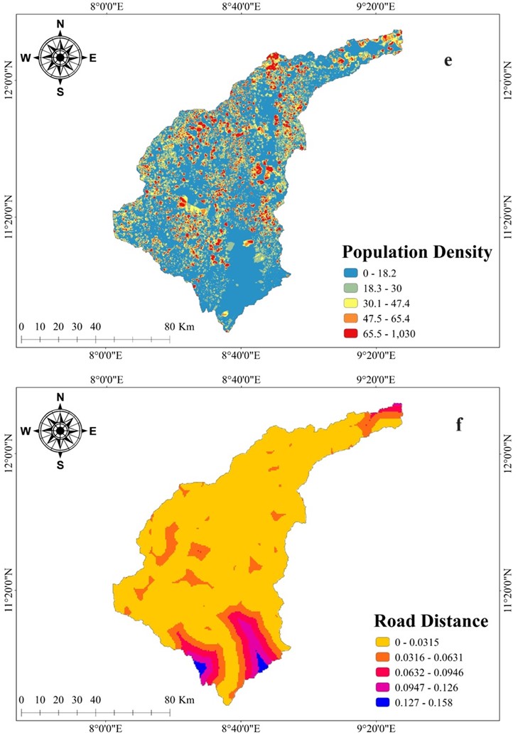
Landuse and land cover (LULC) changes significantly influence hydrological systems, especially in semi-arid regions where such changes amplify flood risks. This study examines the spatiotemporal dynamics of LULC between 2009 and 2023 and their implications for flood risk in downstream communities of the Tiga Dam, Kano State, Nigeria. Using remote sensing and Geographic Information System (GIS) techniques, the analysis reveals a notable decline in shrubland cover from 50.57% in 2009 to 43.33% in 2023, alongside an increase in agricultural land from 19.81% to 23.04%. These changes reflect substantial vegetation loss and land conversion, which have increased surface runoff and reduced infiltration. Hydrological modeling confirms that urban expansion and deforestation have intensified both the frequency and severity of floods in the region. Projections based on current trends indicate continued vegetation degradation and urban sprawl by 2050, elevating future flood risks. The findings underscore the urgent need for sustainable land management practices, including afforestation, conservation agriculture, and effective land-use regulation. Furthermore, integrating geospatial data with hydrodynamic modeling provides critical insights for identifying flood-prone zones and designing risk mitigation strategies. This study highlights the importance of evidence-based, proactive land-use planning to strengthen climate resilience and reduce flood vulnerability. As climate variability and human pressures persist, targeted interventions are crucial to safeguard lives, livelihoods, and infrastructure in vulnerable floodplain areas.
References
Abubakar, A., Yusuf, A. A., & Bawa, M. A. (2023). Assessment of urban flood vulnerability in northern Nigeria using remote sensing and GIS. Natural Hazards Review, 24(2), 04022060. https://doi.org/10.1061/(ASCE)NH.1527-6996.0000582
Adeola, S. T., Olaniyan, A. B., & Bello, M. A. (2023). Exploring flood risk components in Nigeria’s urban centres. Journal of Environmental Planning and Management, 66(4), 731–748.
Adnan, N. A., Rahman, A., & Haddad, K. (2020). Estimation of design flood quantiles in ungauged catchments using an artificial intelligence approach. Journal of Hydrology, 589, 125198. https://doi.org/10.1016/j.jhydrol.2020.125198
Aerts, J. C. J. H., Botzen, W. J. W., Clarke, K. C., Cutter, S. L., Hall, J. W., Merz, B., & Kunreuther, H. (2018). Integrating human behavior dynamics into flood disaster risk assessment. Nature Climate Change, 8(3), 193-199. https://doi.org/10.1038/s41558-018-0085-1
Agbola, B. S., Ajayi, O., Taiwo, O. J., & Wahab, B. (2012). The August 2011 flood in Ibadan, Nigeria: Anthropogenic causes and consequences. International Journal of Disaster Risk Science, 3(4), 207-217. https://doi.org/10.1007/s13753-012-0021-4
Ajaero, C. K., & Anugwa, C. A. (2021). Changing land use and flooding in sub-Saharan Africa: Evidence from Nigeria. Land Use Policy, 103, 105320.
Belew, D., Gebremariam, B., & Dinku, T. (2022). Impacts of land use land cover change on flood risk in the Upper Awash Basin, Ethiopia. Environmental Monitoring and Assessment, 194(6), 1-18. https://doi.org/10.1007/s10661-022-09935-8
Birkmann, J. (2023). Vulnerability indicators in disaster risk management: Definitions, review, and future directions. Progress in Disaster Science, 15, 100254. https://doi.org/10.1016/j.pdisas.2023.100254
Botzen, W. J. W., Aerts, J. C. J. H., & van den Bergh, J. C. J. M. (2019). Climate change adaptation: Flood risks and insurance sustainability. Environmental Research Letters, 14(4), 045017. https://doi.org/10.1088/1748-9326/aafb66
Chen, Y., Wang, J., & Zhang, H. (2021). Integrating hydrological models with remote sensing for flood risk analysis. Water, 13(1), 102. https://doi.org/10.3390/w13010102
Chatterjee, R., Saha, A., & Das, S. (2022). Urban expansion and flood risk in developing countries. Sustainable Cities and Society, 85, 104031.
Dutta, D., Sharma, S., & Jain, V. (2023). Impact of urban expansion on flood vulnerability: A case study of flood-prone regions in South Asia. Natural Hazards, 114(3), 2451-2473. https://doi.org/10.1007/s11069-023-05871-4
Ibrahim, A. M., Lawal, A., & Mustapha, Y. (2022). Geospatial flood risk modeling in Kano River Basin. Environmental Monitoring and Assessment, 194(9), 703.
IPCC. (2014). Climate Change 2014: Impacts, Adaptation, and Vulnerability. Contribution of Working Group II to the Fifth Assessment Report of the Intergovernmental Panel on Climate Change. Cambridge University Press.
Mohammed, U. M., Suleiman, M. T., & Musa, A. (2021). Flood hazard assessment in Kano State, Nigeria using GIS and remote sensing. Arabian Journal of Geosciences, 14, 2164.
Mwangi, P. W., Kimathi, M., & Njogu, H. K. (2023). Land use change and its hydrological impacts in sub-Saharan Africa: A review. Heliyon, 9(3), e13987.
Ndubuisi, C. J., Ajibade, I., & Ojo, T. O. (2022). Managing flood risk through land cover restoration in semi-arid Nigeria. Land, 11(8), 1271. https://doi.org/10.3390/land11081271
Ogunbode, C. A., Olaniran, O. J., & Ibitolu, H. (2022). Impact of dam operations and land use on flood hazards in Nigeria. Applied Water Science, 12, 151.
Oladele, A. A., & Aremu, A. O. (2022). Urban resilience and flood risk management in Nigeria: A policy perspective. Sustainability, 14(7), 3998.
Peng, M., Zhang, Y., & Li, J. (2024). Global flood damages in the 21st century: Trends, economic losses, and mitigation strategies. Environmental Research, 230, 115198. https://doi.org/10.1016/j.envres.2024.115198
Peng, J., Zhao, S., & Li, H. (2024). Economic implications of global flood disasters: Patterns and projections. Climate Risk Management, 42, 100504.
Samson, R., Vithanage, M., & Bandara, W. M. A. (2016). Effects of land use change on flood vulnerability in tropical river basins. Geomatics, Natural Hazards and Risk, 7(4), 1376-1395. https://doi.org/10.1080/19475705.2015.1064953
Sieg, T., & Thieken, A. H. (2022). Depth-damage relationships in flood risk modeling: A review and future directions. Water, 14(9), 1354. https://doi.org/10.3390/w14091354
Usman, S., Musa, A. M., & Yakasai, I. A. (2023). Flood modeling using remote sensing and HEC-RAS in northern Nigeria. Sustainable Water Resources Management, 9, 44.
Yin, J., Yu, D., & Wilby, R. L. (2017). Hydrological impacts of urbanization and climate change in the Pearl River Delta, China. Water Resources Research, 53(10), 8317-8334. https://doi.org/10.1002/2017WR021192
Zhao, Y., Liu, H., & Xu, W. (2021). Effects of urbanization on watershed flood response: A review. Water, 13(5), 703.
Downloads
Published
Issue
Section
Categories
License
Copyright (c) 2025 Abdullahi Balarabe, E. O. Iguisi, Ibrahim Mukhtar, Z. R. Lawal, Abdulrazak Ahmed, Jibril Haruna Umar, Suleiman Adoga Salihu, Abdulhakim Wagini Hassan, Y. Haliru, M. H. Aliyu, Usama Salisu Khalid

This work is licensed under a Creative Commons Attribution 4.0 International License.

