
INTEGRATED GEOELECTRICAL AND HYDRAULIC CHARACTERIZATION OF BASEMENT AQUIFERS FOR GROUNDWATER EXPLORATION IN KUJE DISTRICT, ABUJA, NIGERIA
DOI:
https://doi.org/10.33003/fjs-2025-0911-3893Keywords:
Groundwater, Aquifer Properties, Vulnerability, Abuja, Central NigeriaAbstract
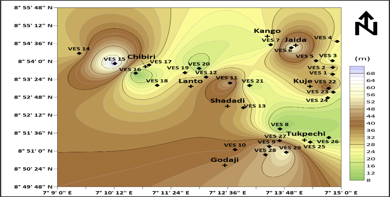
Basement complex terrain is typically made of hard rocks with limited porosity and permeability, which pose a serious challenge to the groundwater system and resulted in water scarcity even in the study area. Twenty-nine Vertical Electrical Soundings and Dar-Zarrouk parameters were analyzed to delineate aquifer systems. Topsoil, lateritic clay, weathered basement, fractured basement, and fresh basement comprised the multi-layered subsurface structure that was shown by the VES curves. Typical subsurface sequences with alternating resistive and conductive layers reveal weathered or fractured aquifers typical of basement terrains. These curve types include KH-type (41.38%), HA-type (24.15%), KHA (10.35%) and QH (6.90%), H, HK, AK, and HAA (≤3.45%). It was determined that the principal aquifers were the weathered and fractured basement layers, with thicknesses ranging from 3 to 52m and resistivity values between 38.0 and 2429.3Ωm. Transverse resistance (250–43,934Ωm²), hydraulic conductivity (0.3–13m/day), longitudinal conductance (0.01–0.32S), and transmissivity (3.5–161m²/day) were among the Dar Zarrouk parameters that showed significant spatial variability. The northeastern sector (Kuje central) had high-yield zones due to favorable permeability and thickness, while the northwestern and southwestern areas (Chibiri and Godaji area) had limited groundwater potential. The aquifers' rate of pollution is poor to moderate. These findings provide a framework for sustainable groundwater exploration in basement complex terrains.
References
Adeeko, T. O. and Buba, A. A. (2016). Using geo-electrical method of estimation in groundwater for irrigation potentials of Kiyi community, Kuje Area Council, Abuja, Nigeria. European Journal of Academic Essays, 3(4), 156-168.
Aderemi, F. L. (2020). Groundwater exploration in a typical basement complex terrain, Southwestern Nigeria. International Research Journal of Pure and Applied Physics, 7(1), 1–6.
Ajayi, O. and Abegunrin, O. O. (2022). Borehole failures in crystalline rocks of South-Western Nigeria. Geology Journal, 34(4), 397–405.
Akanbi, O. A. (2017). Hydrogeologic characterisation of crystalline basement aquifers of part of Ibarapa area, southwestern Nigeria (Doctoral dissertation).
Akintorinwa O. J., Atitebi M.O., Akinlalu A. A. (2020). Hydrogeophysical and aquifer vulnerability zonation of a typical Basement Complex Terrain: A case study of Odode Idanre southwestern Nigeria. Heliyon 6.
Akinwumiju, A.S., Olorunfemi, M.O., Afolabi, O. (2016). GIS based integrated groundwater potential assessment of Osun drainage basin, southwestern Nigeria. Ife Journal of Science, 18(1), 147–168.
Akoteyon, I. S. (2019). Factors affecting household access to water supply in residential areas in parts of Lagos Metropolis, Nigeria. Bulletin of Geography. Socioeconomic Series, 43(2019), 7–24.
Akpah F. A., Musa K. O., Shaibu M. M., Nanfa A. C. And Jimoh J. B. (2023). Integration of Vertical Electrical Sounding (VES) Resistivity and Very Low Frequency Electromagnetic (VLF-EM) Methods in groundwater exploration within Ajaokuta and environs, North Central, Nigeria. FUW Trends in Science & Technology Journal, 8(2), 269-289.
Akpan, A. E., Ebong, D. E., Emeka N. C. (2015). Exploratory assessment of groundwater vulnerability to pollution in Abi, southeastern Nigeria, using geophysical and geological techniques. Environmental Monitoring Assessment, 187, 156.
Aminu, M. B., Nanfa, C. A., Hassan, J. I., Yahuza, I., Christopher, S. D., & Aigbadon, G. O. (2022). Application of electrical resistivity for evaluation of groundwater occurrence within Adankolo Campus and Environs, Lokoja North Central, Nigeria. European Journal of Environment and Earth Sciences, 3 (1), 235.
Auduson, A. E. (2018). Concise Applied Geophysics: A Practical Approach. First edition, 2018- In press, University Press PLC, Ibadan, Nigeria.
Ayedun, H., Gbadebo, A. M., Idowu, O. A., & Arowolo, T. A. (2015). Toxic elements in groundwater of Lagos and Ogun States, Southwest, Nigeria and their human health risk assessment. Environmental monitoring and assessment, 187, 1-17.
Balogun, O., (2001). The Federal Capital Territory of Nigeria: A Geography of its Development. Ibadan University Press. Pp. 35-37.
Braga, A. C. D. O., Malagutti Filho, W., & Dourado, J. C. (2006). Resistity (DC) method applied to aquifer protection studies. Revista Brasileira de Geofísica, 24, 573-581.
Cassiani, G., & Medina, M. A. (1997). Incorporating auxiliary geophysical data into ground‐water flow parameter estimation. Groundwater, 35(1), 79-91.
Ejepu, J. S., Olasehinde, P., Okhimamhe, A. A., & Okunlola, I. (2017). Investigation of Geological Structures of Hydrogeological Importance of 1: 100,000 Sheet 185 (Paiko) North-Central Nigeria Using Integrated Geophysical and Remote Sensing Techniques. Preprints.
Henriet, J. P. (1976). Direct applications of the Dar Zarrouk parameters in ground water surveys. Geophysical prospecting, 24(2), 344-353.
Hudu, A. S., Fabian, A. A., Kizito, O. M. and Jacob, B. J. (2024). Application of primary and secondary resistivity parameters in evaluating aquifer potential and vulnerability within Kabba, North Central Nigeria. FUDMA Journal of Sciences (FJS), 8 (4), 221 – 234.
Ibrahim K. O., Joel O., Abdulrahman A., Bankole S. A. (2015). Physicochemical evaluation of groundwater in Kuje, Federal Capital Territory, Abuja, Nigeria. Nigerian Journal of Technological Development, 12(1), 1-5.
Jassim, F. A., & Altaany, F. A. (2013). Image interpolation using Kriging technique for spatial data. Canadian Journal on Image Processing and Computer Vision, 4(2), 16–21.
Jimoh, J.B., Musa, O.K, Ahmed II J.B. (2025). An Integrated method for mapping groundwater potential in part of Abuja, Central Nigeria. Scientia Africana, 24(1), 339-362.
Joel, E. S., Olasehinde, P. I., Adagunodo, T. A., Omeje, M., Oha, I., Akinyemi, M. L., & Olawole, O. C. (2020). Geo-investigation on groundwater control in some parts of Ogun state using data from Shuttle Radar Topography Mission and vertical electrical soundings. Heliyon, 6(1).
Kizito, O.M., Ahmed II, J.B., Fabian, A.A., Ernest, O.A., Ikenna, A.O., Solomon, S. J., Andrew, C. N., Jacob, B.J. (2023a): Assessment of groundwater potential and aquifer characteristics using inverted resistivity and pumping test data within Lokoja area, North-Central Nigeria. Communication in physical sciences, 9 (3), 336 – 349.
Kizito, O.M., Ikenna, A.O., Aaron, E. A., Solomon, S. J., Ernest, O. A., Fabian, A.A, Jacob, B. J. (2023b). Integrating geoelectrical and borehole data in the characterization of basement-rock aquifers in the Lokoja area, Northcentral Nigeria. Geosystems and Geoenvironment 2, 10 (02) 17.
Kollu, U., Rao, B. M., Sduarshan, R., Reddy, P. C., & Goud, N. S. (2021). Evaluation of Dar Zarrouk parameters in hard rock terrain in parts of Nuthankal Mandal, Suryapet district, Telangana, India. Int J Eng Sci Invent, 10(12), 10-26.
Konwea. C. I., Ajayi, J. O., Bakare, T. A. (2020). Performance of Boreholes and Hand-Dug Wells in The Crystalline Rocks of Osun State, Southwestern Nigeria. International Journal of Scientific and Technology Research, 9(1), 3408–3418.
Krásný, J. (1993). Classification of transmissivity magnitude and variation. Groundwater, 31(2), 230-236.
Maillet, R. (1947). The fundamental equations of electric prospecting. Geophysics, 12, 529–556.
Mephors, J. O., Ogunmuyiwa, C. O., Afolabi, O. S., Agbor, C. F., Ogoliegbune, O. M., Ofordu, C. S. (2021). Use of digital elevation models to map out the groundwater resources base of Kuje area to Federal Capital Territory, Abuja, Nigeria. Journal of Applied Science and Environmental Management, 25(7), 1207-1212.
Musa, K. O., Ibrahim, A., Aigbadon, G. O., Akudo, E. O., Akakuru, O., Akpah, F. A., Jacob, B. J., Moses, A., & Baba Aminu, M. A. (2025). Integration of geological and geophysical techniques in groundwater mapping within Lokoja–Jakura schist belt, North Central, Nigeria. World Journal of Engineering.
Nanfa, C. A., Musa, O. K., Akpah, F. A., Shaibu, M. M., Jimoh, J. B., Baba Aminu, M., John, O. W., Faith, F. O., Rebecca, J. A. and Samson, A. A. (2025). Investigation of basement aquifer hydraulics and protective capacity within Jimgbe and environs, North Central Nigeria. Communication in Physical Sciences, 12(2) 696-709.
Nejad, H. T. (2009). Geoelectric investigation of the aquifer characteristics and groundwater potential in Behbahan Azad University Farm, Khuzestan Province, Iran.
Ogunkoya, O.O. (2017). Obafemi Awolowo University Ile-Ife Water Supply Challenges. Department of Geography, 71, 2017.
Ojigi, M. L., (2005). Digital Terrain Modeling and Drainage Analysis of Northern Part of Abuja Phase II Development Area, Using Geospatial Techniques. A PhD. Dissertation in Applied Remote Sensing, Fed. Univ. of Tech., Minna, Nigeria. May 2005, 178pg.
Ojigi, M. L., Achema, E. A. and Alade, T. A. (2012) Geospatial Analysis of Landslide Vulnerability in Kuje and Environs, Abuja Nigeria In: Laryea, S., Agyepong, S.A., Leiringer, R. and Hughes, W. (Eds) Procs 4th West Africa Built Environment Research (WABER) Conference, 24-26 July 2012, Abuja, Nigeria, 1067-1077.
Okonkwo, A. C., & Ugwu, G. Z. (2015). Determination of Dar-zarrouk parameters for prediction of Aquifer protective capacity: A case of Agbani Sandstone Aquifer, Enugu State, Southeastern Nigeria. International Research Journal of Geology and Mining, 5(2), 12-19.
Osumeje, J. O., Eshimiakhe, D., Oniku, A. S., & Lawal, K. M. (2024). Application of remote sensing and electrical resistivity technique for delineating groundwater potential in North Western Nigeria. Scientific Reports, 14(1), 22299.
Oyawoye, M. O. (1972). The basement complex of Nigeria. African geology, 67-99.
Shiru et al., (2020): Challenges in water resources of Lagos mega city of Nigeria in the context of climate change. Journal of Water and Climate Change, 11(4), 1067–1083.
Simon, S. S., Ishaku, J. M., Seli, A. B., & Boniface, F. (2022). Evaluation of groundwater potentials using Dar Zarrouk parameters in Mapeo and Environs, North-Eastern Nigeria. Dutse Journal of Pure and Applied Sciences, 8(3b), 124-135.
Singhal, B. B. S., & Gupta, R. P. (2010). Applied hydrogeology of fractured rocks. Springer Science & Business Media.
Sunkari, E. D., Abu, M., Bayowobie, P. S., & Dokuz, U. E. (2019). Hydrogeochemical appraisal of groundwater quality in the Ga west municipality, Ghana: Implication for domestic and irrigation purposes. Groundwater for Sustainable Development, 8, 501-511.
Sunkari, E. D., Kore, B. M., & Abioui, M. (2021). Hydrogeophysical appraisal of groundwater potential in the fractured basement aquifer of the federal capital territory, Abuja, Nigeria. Results in Geophysical Sciences, 5, 100012.
Talabi, A. O. (2018). Estimated volume of water in shallow wells of Ekiti State, Southwestern Nigeria: implications on groundwater sustainability. Arabian Journal of Geosciences, 11(21), 681.
Toto, E. A., Kerrouri, C., Zouhri, L., Basri, M. E., Ibenbrahim, A., Mohamad, H., & Benammi, M. (2008). Geoelectrical exploration for groundwater in Al Maha Forest, Ain Jouhra, Morocco. Hydrological Processes: An International Journal, 22(11), 1675-1686.
Van Beers, W. C. M., & Kleijnen, J. P. C. (2003). Kriging for interpolation in random simulation. Journal of Operational Research Society, 54,255–262.
Zohdy, A. A., Eaton, G. P., & Mabey, D. R. (1974). Application of Surface Geophysics to Ground-water Investigations: Techniques of Water Resources Investigations of the United States Geological Survey: Book 2: Collection of Environmental Data: Chapter D1. United States Department of the Interior.
Downloads
Published
Issue
Section
Categories
License
Copyright (c) 2025 Michael Soga Ikuemonisan, Musa Ojochenemi Kizito, Fabian Apeh Akpah, Jacob Bolaji Jimoh

This work is licensed under a Creative Commons Attribution 4.0 International License.

